A map labeling method that uses all-digital forms to mark the position and orientation of the city as the center

An all-digital, urban technology, applied in geographic information databases, structured data retrieval, special data processing applications, etc., to achieve the effects of easy judgment calculation, easy understanding, and easy memory

Active Publication Date: 2021-05-04
高晓雷
View PDF7 Cites 0 Cited by
  • Summary
  • Abstract
  • Description
  • Claims
  • Application Information

AI Technical Summary

Problems solved by technology

[0006] Purpose of the invention: Aiming at the problem that it is not easy to directly mark and locate the address on the map, the present invention proposes a map marking method centering on the city and marking the position and positioning in full digital form

Method used


Image

  • A map labeling method that uses all-digital forms to mark the position and orientation of the city as the center
  • A map labeling method that uses all-digital forms to mark the position and orientation of the city as the center
  • A map labeling method that uses all-digital forms to mark the position and orientation of the city as the center

Examples


Embodiment 1

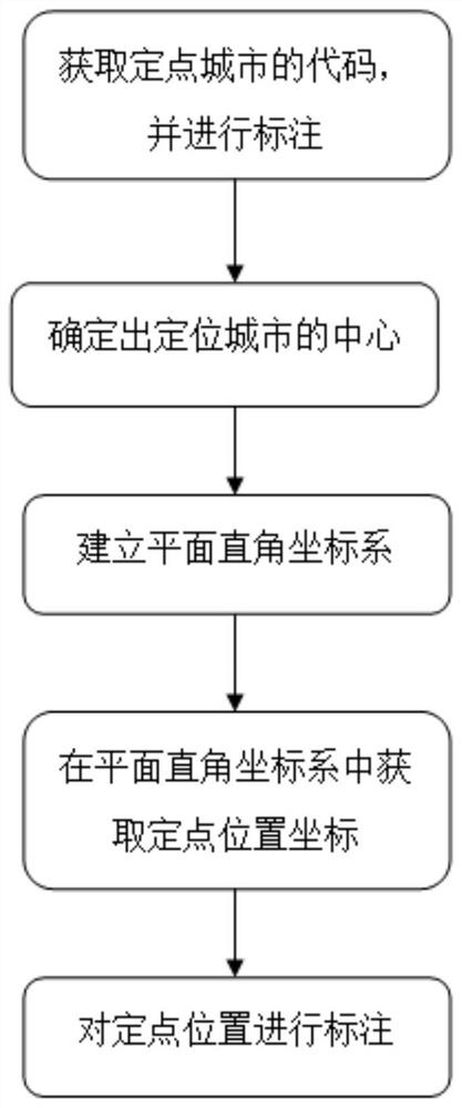
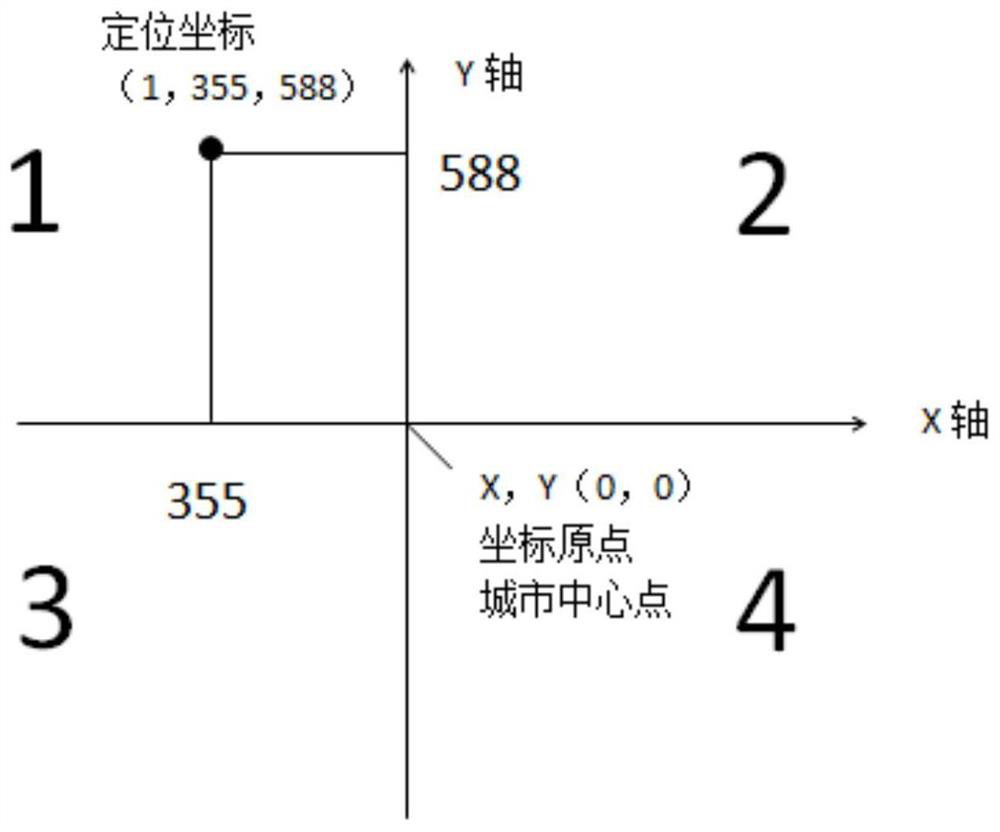
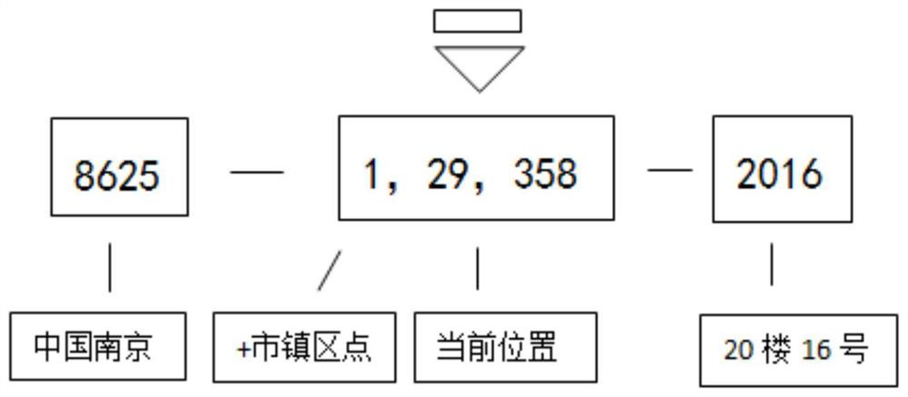
[0028] refer to figure 1 , the present embodiment provides a map marking method centering on the city and marking the position and positioning in full digital form. In this embodiment, Nanjing City, Jiangsu Province, China is used as a fixed-point city for a specific description. The map marking method specifically includes Follow the steps below:

[0029] Step S1: After the user determines the fixed-point location, the code of the positioning city where the fixed-point location is located can be identified by a fixed-point method. Specifically, users can identify the code of the location city through mobile terminals, GPS, base station signals, and broadband access ports, where the code of the location city can be marked with international and domestic telephone area code numbers. In this embodiment, the code of Nanjing City, Jiangsu Province, China can be marked as 8625 or 025, or the first 7 digits of the mobile phone number can be used as the mark, for example: 1333772. ...


PUM


Abstract

The invention discloses a method for marking a map with a city as the center and marking the position and location in full digital form. The steps are as follows: S1: determine the fixed-point position, and identify the code of the fixed-point city where the fixed-point position is located; S2: input in the electronic map The code of the fixed-point city is used to obtain the regional map of the fixed-point city; S3: In the regional map of the fixed-point city, the center of the fixed-point city is determined, and a plane Cartesian coordinate system is established. Determine the coordinates of the fixed-point position in the plane Cartesian coordinate system, and mark the fixed-point position. The invention uses numbers instead of text input, which not only makes input simple, but also facilitates memorization, release and mutual communication. At the same time, digital expressions can be directly calculated without secondary translation into machine codes, so they can be widely used in big data and urban digitization It can also meet the requirements of future digitalization of geographic information.

Description

technical field [0001] The invention relates to the technical field of position labeling, in particular to a map labeling method centering on a city and marking the position and positioning in full digital form. Background technique [0002] An electronic map is a digital map, which is a map that is stored and consulted digitally using computer technology. The method of storing information in electronic maps generally uses vector image storage. The map scale can be enlarged, reduced or rotated without affecting the display effect. In the early days, bitmap storage was used, and the map scale could not be enlarged or reduced. Modern electronic map software generally uses geographic information systems to store and transmit map data, and other information systems. [0003] At present, the map markers entered in the navigation terminal are generally limited to POI (Point of Interest). Use the map browsing mode to move the center of the map to the location of the registration p...

Claims


Application Information

Patent Timeline
Patent Type & Authority Patents(China)
IPC IPC(8): G06F16/29
CPCG06F16/29
Inventor 高晓雷
Owner 高晓雷
Why Eureka
Try Eureka