Intelligent geographic surveying and mapping device

A surveying and mapping device and geographic technology, applied in the field of information technology, can solve the problems of data transmission without power support, lack of power, distance measurement and surveying and mapping cannot be completed, etc.

Inactive Publication Date: 2020-02-11
徐州市创新科技发展有限公司
View PDF10 Cites 0 Cited by
  • Summary
  • Abstract
  • Description
  • Claims
  • Application Information

AI Technical Summary

Problems solved by technology

[0002] The function of the intelligent geographic surveying and mapping device lies in the function of surveying, mapping and ranging in the way of travel, which is different from the traditional methods of surveying, mapping and ranging, improving accurate data and improving efficiency, but the current stage of intelligence The use of modern geographic surveying and mapping devices does not have this function in surveying and mapping, which makes it impossible to complete ranging and surveying, which increases the workload of data collection, and does not have large-capacity power supply support in data transmission. Complete data collection in a short time

Method used


Image

  • Intelligent geographic surveying and mapping device
  • Intelligent geographic surveying and mapping device
  • Intelligent geographic surveying and mapping device

Examples


Embodiment Construction

[0013] The present invention will be further described below in conjunction with the accompanying drawings.

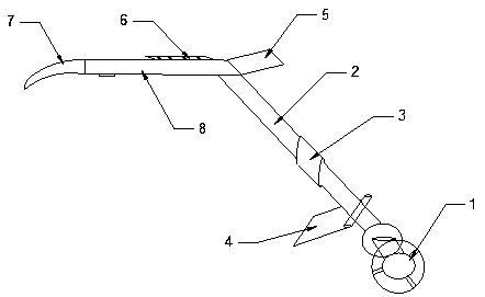
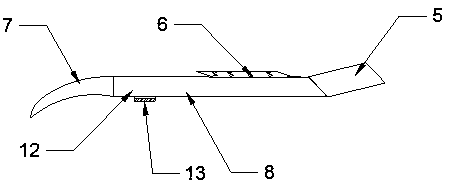
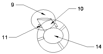
[0014] Such as Figure 1 to Figure 3 As shown, the present invention is an intelligent geographical surveying and mapping device, which includes a surveying wheel 1, a telescopic rod 2, a telescopic lock 3, a foot support 4, a liquid crystal display 5, a multifunctional keyboard 6, a handle 7 and a power supply compartment 8. The upper end of the telescopic rod 2 is connected to the bottom surface of one end of the power supply compartment 8, the other end surface of the power supply compartment 8 is fixedly connected to the handle 7, and the upper surface of the power supply compartment 8 is fixedly connected to a multi-function keyboard. 6. A liquid crystal display 5 is fixedly connected to the surface of one end of the power supply compartment 6 close to the telescopic rod. The middle surface of the telescopic rod 2 is locked with a telescopic lock 3. The lower end ...


PUM


Abstract

The invention relates to an intelligent geographic surveying and mapping device. The intelligent geographic surveying and mapping device comprises a surveying wheel, a telescopic rod, a telescopic lock catch, a kickstand, a liquid crystal display, a multifunctional keyboard, a handle and a power bin, the upper end of the telescopic rod is connected to the bottom surface of one end of the power bin, the surface of the other end of the power bin is fixedly connected to the handle, the multifunctional keyboard is fixedly connected to the surface of the upper part of the power bin, the liquid crystal display is fixedly connected to the surface of the end, close to the telescopic rod, of the power bin, the middle surface of the telescopic rod is in lock catch connection with the telescopic lockcatch, the lower end of the telescopic rod is connected to a fixed roller, the fixed roller is connected with the surveying wheel through a fixed rolling shaft, the lower surface of the telescopic rod is connected with the kickstand through a rolling shaft, the surveying wheel is connected with the liquid crystal display through a wire, and the power bin is sequentially connected with the liquidcrystal display and the multifunctional keyboard through wires.

Description

technical field [0001] The invention relates to an intelligent geographic surveying and mapping device, which belongs to the field of information technology. Background technique [0002] The function of the intelligent geographic surveying and mapping device lies in the function of surveying, mapping and ranging in the way of travel, which is different from the traditional methods of surveying, mapping and ranging, improving the accuracy of data and improving efficiency, but the current stage of intelligence The use of modern geographic surveying and mapping devices does not have this function in surveying and mapping, which makes it impossible to complete ranging and surveying, which increases the workload of data collection, and does not have large-capacity power supply support in data transmission. Complete data collection in a short time. Contents of the invention [0003] Aiming at the problems existing in the above-mentioned prior art, the present invention provide...

Claims


Application Information

Patent Timeline
Patent Type & Authority Applications(China)
IPC IPC(8): G01C15/00
CPCG01C15/00
Inventor 夏小平
Owner 徐州市创新科技发展有限公司
Why Eureka
Try Eureka