Three-dimensional modeling and visualization method for low airspace

A technology of 3D modeling and 3D modeling, applied in the field of 3D modeling, can solve the problems of fast modeling speed, lack of visualization of low-altitude scenes of UAVs, etc., and achieve the effect of fast modeling speed

Pending Publication Date: 2020-03-17
北航(四川)西部国际创新港科技有限公司
View PDF2 Cites 13 Cited by
  • Summary
  • Abstract
  • Description
  • Claims
  • Application Information

AI Technical Summary

Problems solved by technology

[0005] Aiming at the defects of the prior art, the present invention provides a low-airspace-oriented three-dimensional modeling and visualization method to solve the current problem of lac

Method used


Image

  • Three-dimensional modeling and visualization method for low airspace
  • Three-dimensional modeling and visualization method for low airspace
  • Three-dimensional modeling and visualization method for low airspace

Examples


Example Embodiment

[0056] In order to make the object, technical solution and advantages of the present invention clearer, the present invention will be further described in detail below with reference to the accompanying drawings and examples.

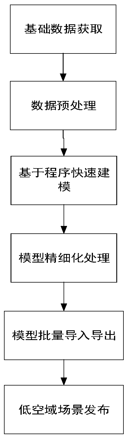
[0057] like figure 1 As shown, a method for 3D modeling and visualization in low airspace includes the following steps:

[0058] Step 1: Basic Data Acquisition

[0059] The acquisition of basic data mainly includes the acquisition of vector data, terrain image data, and texture data.

[0060] 1) Acquisition of vector data

[0061] The vector data required in 3D modeling in low airspace mainly includes road data, building data, river data, and green belt data. By intercepting existing GIS data, or vectorizing on image maps. The attribute information of the modeling entity requires the staff to collect relevant information, go to the site to investigate and obtain the latest information, and assign the corresponding attribute information to the corres...


PUM


Abstract

The invention discloses a three-dimensional modeling and visualization method for a low airspace. The method is mainly used for solving the problem that the existing unmanned aerial vehicle-oriented low-airspace scene visualization technology is relatively deficient. Starting from two-dimensional basic data required for establishing a low-airspace model, a data preprocessing method is given, thenprogrammed batch modeling is performed based on various models of a low-airspace scene, and meanwhile, the model is refined through an image-based method to obtain a refined low-airspace three-dimensional model. According to the established low-airspace three-dimensional model, low-airspace three-dimensional visualization of the Web side is realized through ArcGIS server construction. The method has the advantages that the three-dimensional model is established on the basis of a computer program and an image combination mode, the advantages of the two technologies are integrated, the modelingspeed is high, refined modeling can be conducted on complex buildings, the three-dimensional model is established for the low airspace, and the method can be applied to various navigation airplanes and unmanned aerial vehicles.

Description

technical field [0001] The invention relates to the technical field of three-dimensional modeling, in particular to a low-airspace-oriented three-dimensional modeling and visualization method, which can be used for various general-purpose aircraft, unmanned aerial vehicles, and the like. Background technique [0002] With the reform of low airspace at home and abroad, under the circumstance that the flight frequency of drones is increasing and the scope of application is expanding, the application of two-dimensional GIS is increasingly unable to meet the application needs of various fields, and the development of low airspace that can be used for drones The demand of GIS system for 3D modeling and 3D visualization is increasingly urgent. [0003] At present, 3D modeling methods are mainly classified into four categories. The first category is to use airborne turbulence radar or 3D scanner to obtain 3D point cloud data of surface information, and then construct a 3D model. Th...

Claims


Application Information

Patent Timeline
IPC IPC(8): G06T17/05
CPCG06T17/05
Inventor 周强申炎卫永安
Owner 北航(四川)西部国际创新港科技有限公司
Why Eureka
Try Eureka