Mountain three-dimensional geologic body modeling method and comprehensive geological information demonstration system

A modeling method and 3D geotechnical technology, applied in the field of 3D geological body modeling and demonstration, can solve problems such as large amount of model data, inability to meet the geological requirements for modeling and guaranteeing, and difficulty in meeting the needs of rapid modeling of 3D geological bodies in mountainous areas. , to achieve the effect of increased reliability, fast rendering speed, and fast modeling speed

Inactive Publication Date: 2016-06-29
JILIN UNIV
View PDF6 Cites 11 Cited by
  • Summary
  • Abstract
  • Description
  • Claims
  • Application Information

AI Technical Summary

Problems solved by technology

The data sources used in the modeling method are high-density electrical data and magnetotelluric sounding data, which cannot achieve the modeling of geological body data obtained through seismic exploration and other geophysical methods and geological methods to ensure geological requirements
In addition, the above-mentioned patents all use a tetrahedral model, and do not adopt a volume model structure that is suitable for the complexity of the geological body in the study area. Although it can represent complex three-dimensional geological bodies, the large amount of model data is not conducive to rapid implementation. The interactive design, adjustment and display of the model is difficult to meet the rapid modeling requirements of 3D geologic

Method used


Image

  • Mountain three-dimensional geologic body modeling method and comprehensive geological information demonstration system
  • Mountain three-dimensional geologic body modeling method and comprehensive geological information demonstration system
  • Mountain three-dimensional geologic body modeling method and comprehensive geological information demonstration system

Examples


Embodiment Construction

[0040] Below in conjunction with accompanying drawing and embodiment do further detailed description:

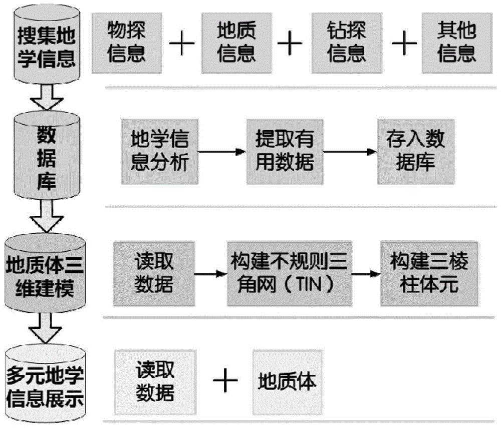
[0041] The modeling method of three-dimensional geological bodies in mountainous areas and the demonstration system of integrated geoscience information include the following steps:

[0042] a. Collect and study multivariate data in mountainous areas, that is, comprehensive geoscience information, specifically including geological, drilling, seismic, electrical, remote sensing and other data. Through the joint interpretation of the above data, the interpretation results of 3D geological bodies are obtained;

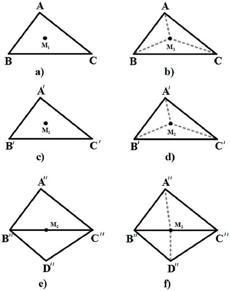
[0043] b. Establish a point model, and establish a horizontal grid according to the model accuracy requirements of the 3D geological body. The unit grid is a square, and the side length of the square is defined as Take λ=1;

[0044] c. Project the horizontal grids to each interface respectively, then the set of projection points of the center points of each horizonta...


PUM


Abstract

The invention relates to a mountain three-dimensional geologic body modeling method and a comprehensive geological information demonstration system.The method includes the steps that firstly, multivariate data in a mountain area are searched for; secondly, a point model of a three-dimensional geological model is obtained according to precision; thirdly, a facial model and a body model are built, a triangular prism model can be changed to be a pyramid model, an irregular tetrahedron model and a planar model, and quite high adaptivity is achieved; finally, comprehensive three-dimensional demonstration is conducted in combination with the comprehensive geological information of a researched area and the built three-dimensional geological model.The mountain three-dimensional geologic body modeling method and the comprehensive geological information demonstration system are high in modeling speed, high in rendering speed and suitable for geological three-dimensional modeling; separate display of the three-dimensional geological model and the comprehensive geological information.The method and system can be applied to mining area modeling and regional geological modeling; multiple types of geophysical data modeling including seismic exploration and the like are supported, and the method and system can be applied to geological and earth physics experiment teaching and practice and can also be applied to comparison experiment research of multiple types of geophysical methods.

Description

Technical field: [0001] The invention relates to a three-dimensional geological body modeling and demonstration. It is especially suitable for the rapid construction of geological body models in mountainous environments and the three-dimensional presentation of comprehensive geoscience information including geology, drilling, and earthquakes. Background technique: [0002] The traditional method of expressing geological exploration results mainly uses two-dimensional maps such as geological maps and geological profiles, and it is difficult to express and demonstrate geological bodies intuitively and vividly in three dimensions, which brings many difficulties to geologists. With the continuous deepening of geological exploration, people's need to understand geological bodies is increasing. The three-dimensional modeling and three-dimensional demonstration of geological bodies through computer visualization technology has become one of the hotspots and difficulties in the fiel...

Claims


Application Information

Patent Timeline
IPC IPC(8): G06T17/05G06F17/30
CPCG06F16/29G06T17/05
Inventor 姜弢陈振振徐学纯晁云峰郑常青岳永高汪彥龙
Owner JILIN UNIV
Why Eureka
Try Eureka