
Optical axis orientation adjusting method based on satellite-borne remote sensing instrument

An adjustment method, a technology of optical axis pointing, applied in the field of remote sensing, can solve the problems affecting the directional imaging accuracy and stability of spaceborne remote sensing instruments, the inability to achieve fast and accurate pointing of the optical axis, and the failure of radiation calibration

Pending Publication Date: 2020-04-21
SPACETY CO LTD (CHANGSHA)
View PDF7 Cites 5 Cited by
  • Summary
  • Abstract
  • Description
  • Claims
  • Application Information

AI Technical Summary

Problems solved by technology

However, on the one hand, the on-orbit adjustment system of the optical axis pointing disclosed in this patent does not take into account that the on-orbit optical axis adjustment of the satellite is likely to cause the jitter of the spaceborne remote sensing instrument, let alone the series of uncertain factors and inherent interference of the satellite’s on-orbit motion , for remote sensing satellites that require high stability and high control precision, the jitter caused by the above-mentioned optical axis pointing adjustment and the uncertainty brought by the satellite in orbit will seriously affect the accuracy and stability of directional imaging of spaceborne remote sensing instruments, which will not only lead to relative The failure of radiometric calibration also makes it difficult to image clearly; on the other hand, the on-orbit adjustment system of the optical axis pointing disclosed in this patent cannot realize the rapid and accurate adjustment of the optical axis during the adjustment process only by relying on the measurement of the rotation angle and the judgment mechanism of the preset threshold. precise pointing

Method used


Image

  • Optical axis orientation adjusting method based on satellite-borne remote sensing instrument
  • Optical axis orientation adjusting method based on satellite-borne remote sensing instrument
  • Optical axis orientation adjusting method based on satellite-borne remote sensing instrument

Examples


Embodiment 1

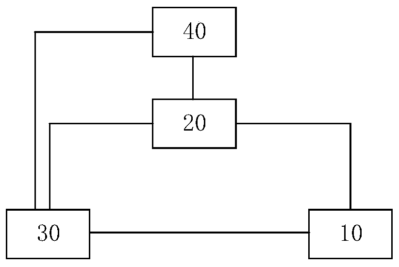
[0030] Aiming at the insufficiency of the existing on-orbit adjustment method of the optical axis pointing of the spaceborne remote sensing instrument, the present invention provides an adjustment method based on the optical axis pointing of the spaceborne remote sensing instrument, such as figure 1 As shown, the adjustment methods include at least:

[0031] S100: When the control unit 30 generates a preset end position for optical axis adjustment according to the instruction of the satellite ground system 40, the control unit 30 controls the execution unit 10 to adjust the optical axis to approach the preset end point. Preferably, the execution unit 10 receives the control information sent by the control unit 30 to adjust the optical axis of the spaceborne remote sensing instrument, thereby changing the direction of the optical axis. The pointing measurement unit 20 measures the pointing state of the optical axis and feeds it back to the control unit 30 . Preferably, the po...

Embodiment 2

[0052] This embodiment is a further improvement and / or supplement to Embodiment 1, and repeated content will not be repeated here. The whole and / or part of the contents of the preferred implementations of other embodiments may be used as supplements to the present embodiment without causing conflict or contradiction.

Embodiment approach

[0053] According to a preferred embodiment, a system for adjusting the pointing of an optical axis based on a spaceborne remote sensing instrument at least includes: an execution unit 10 , a pointing measurement unit 20 and a control unit 30 . The execution unit 10 adjusts the optical axis of the spaceborne remote sensing instrument based on the control information sent by the control unit 30, thereby changing the direction of the optical axis. The pointing measurement unit 20 is used to measure the pointing state of the optical axis adjusted by the execution unit 10 and / or receive measurement data from the satellite ground system 40 to obtain the pointing state of the optical axis, and feed it back to the control unit 30 . In the case that the control unit 30 generates a preset end position for optical axis adjustment according to the instruction of the satellite ground system 40, the control unit 30 responds to the feedback from the pointing measurement unit 20 by forming a c...


PUM


Abstract

The invention relates to an optical axis orientation adjusting method based on a satellite-borne remote sensing instrument. The optical axis orientation adjusting method at least comprises the following steps that under the condition that a control unit generates a preset termination position for optical axis adjustment according to an instruction of a satellite ground system, the control unit generates a dynamic limiting region at least comprising a boundary layer based on an expected orientation state sent by the satellite ground system and an orientation state fed back by an orientation measurement unit, and controls the execution unit to adjust the optical axis to move to the preset termination position in a mode of being bound to the dynamic limiting region.

Description

technical field [0001] The invention belongs to the technical field of remote sensing, and in particular relates to a method for adjusting the direction of an optical axis based on a spaceborne remote sensing instrument. Background technique [0002] With the wide application of satellites in weather forecasting, resource detection, ocean observation, and disaster reduction, users have put forward higher and higher requirements for the resolution and measurement accuracy of remote sensing instruments carried by satellites. If the optical axis of the remote sensing instrument cannot be precisely pointed to the target area, corresponding accurate data or images cannot be obtained, which may cause the failure of the entire satellite remote sensing mission. Therefore, it is very urgent to improve the pointing accuracy of the optical axis of remote sensing instruments, and measures to adjust the pointing of the optical axis must be taken to ensure the normal and efficient work of...

Claims


Application Information

Patent Timeline
IPC IPC(8): G05D3/12
CPCG05D3/12
Inventor 谢成荫杜志贵杨峰任维佳
Owner SPACETY CO LTD (CHANGSHA)
Learn More