
Method and device for compiling black shale quantitative paleo-geographic map

A black shale and paleogeography technology, applied in the field of shale oil and shale gas exploration, can solve the problems of low accuracy of quantitative paleogeographic maps of black shale, and achieve the effect of improving the accuracy

Pending Publication Date: 2020-06-16
PETROCHINA CO LTD
View PDF4 Cites 1 Cited by
  • Summary
  • Abstract
  • Description
  • Claims
  • Application Information

AI Technical Summary

Problems solved by technology

[0004] The embodiment of the present invention provides a method for compiling a quantitative paleogeographic map of black shale to solve the technical problem of low accuracy of the quantitative paleogeographic map of black shale in the prior art

Method used


Image

  • Method and device for compiling black shale quantitative paleo-geographic map
  • Method and device for compiling black shale quantitative paleo-geographic map
  • Method and device for compiling black shale quantitative paleo-geographic map

Examples


Embodiment Construction

[0029] In order to make the object, technical solution and advantages of the present invention clearer, the present invention will be described in further detail below in conjunction with the embodiments and accompanying drawings. Here, the exemplary embodiments and descriptions of the present invention are used to explain the present invention, but not to limit the present invention.

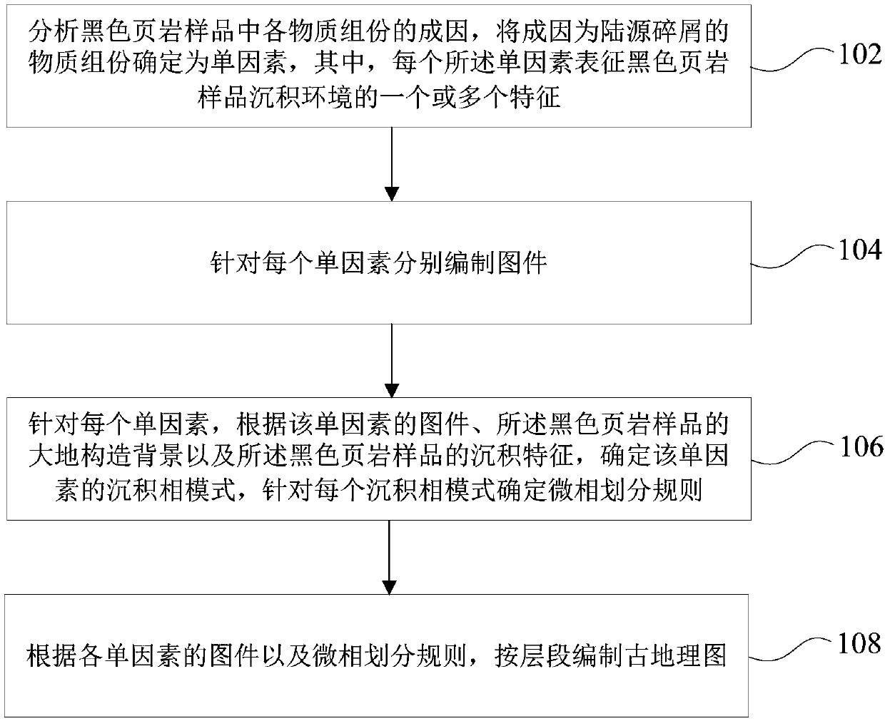
[0030] In an embodiment of the present invention, a method for compiling a quantitative paleogeographic map of black shale is provided, such as figure 1 As shown, the method includes:

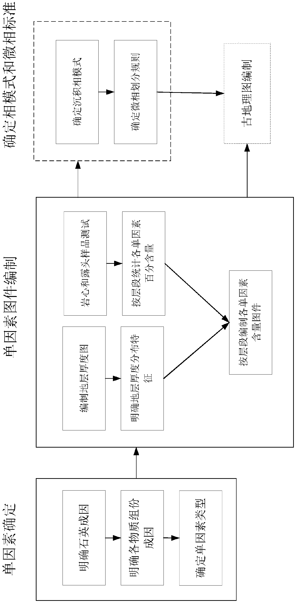
[0031] Step 102: Analyze the origin of each material component in the black shale sample, and determine the material component that is caused by terrigenous clastics as a single factor, wherein each of the single factors represents one or more of the depositional environment of the black shale sample feature;

[0032] Step 104: prepare maps for each single factor;

[0033] Step 106: For each single factor, ac...


PUM


Abstract

The embodiment of the invention provides a method and device for compiling a black shale quantitative paleo-geographic map, and the method comprises the steps: analyzing the causes of all material components in a black shale sample, and determining the material components of land source debris as a single factor; compiling a map for each single factor; for each single factor, determining a sedimentary facies mode of the single factor according to the map of the single factor, the geodetic structure background of the black shale sample and the sedimentary characteristics of the black shale sample, and determining a microfacies division rule for each sedimentary facies mode; and according to the map of each single factor and the microfacies division rule, compiling an ancient geographic mapaccording to the layer sections. According to the scheme, the substance components of the terrestrial debris are determined as the single factors, and the ancient geographic map is compiled accordingto the layer sections according to the map of each single factor and the microfacies division rule, so that the accuracy of the black shale quantitative ancient geographic map is improved, and a basisis provided for clarification of black shale distribution and sedimentary facies distribution and optimization of favorable zones and targets.

Description

technical field [0001] The invention relates to the technical field of shale oil and shale gas exploration, in particular to a method and device for compiling a quantitative paleogeographic map of black shale. Background technique [0002] Quantitative paleogeographic maps are the basis for clarifying the distribution of black shale, evaluating favorable shale oil and shale gas exploration zones, and determining well location targets. Since the single-factor analysis and multi-factor comprehensive quantitative paleogeographic map compilation method was proposed in the 1990s, through the compilation of large-scale quantitative paleogeographic maps, major breakthroughs have been made in oil and gas exploration and development in major petroleum basins in China. Single-factor analysis and multi-factor comprehensive mapping methods have been applied in crude clastic rock and carbonate rock oil and gas exploration. By compiling single-factor distribution maps that can reflect a c...

Claims


Application Information

Patent Timeline
Patent Type & Authority Applications(China)
IPC IPC(8): G06T11/00G06F16/29
CPCG06T11/00
Inventor 施振生郭长敏
Owner PETROCHINA CO LTD
Learn More