Average elevation plane-based image rapid geometric preprocessing method

A technology of average elevation and preprocessing, applied in the field of preprocessing, it can solve the problems of reduced timeliness, increased I/O overhead, and difficulty in adapting to emergency situations, so as to reduce I/O and improve efficiency.

Inactive Publication Date: 2020-07-03
WUHAN UNIV
View PDF5 Cites 0 Cited by
  • Summary
  • Abstract
  • Description
  • Claims
  • Application Information

AI Technical Summary

Problems solved by technology

Because this traditional ground pretreatment system needs to output two kinds of products, it increases the I / O overhead, resulting in reduced timeliness, and it is difficult to adapt to emergency situations such as earthquakes, floods, and forest fires.

Method used


Image

  • Average elevation plane-based image rapid geometric preprocessing method
  • Average elevation plane-based image rapid geometric preprocessing method
  • Average elevation plane-based image rapid geometric preprocessing method

Examples


Embodiment

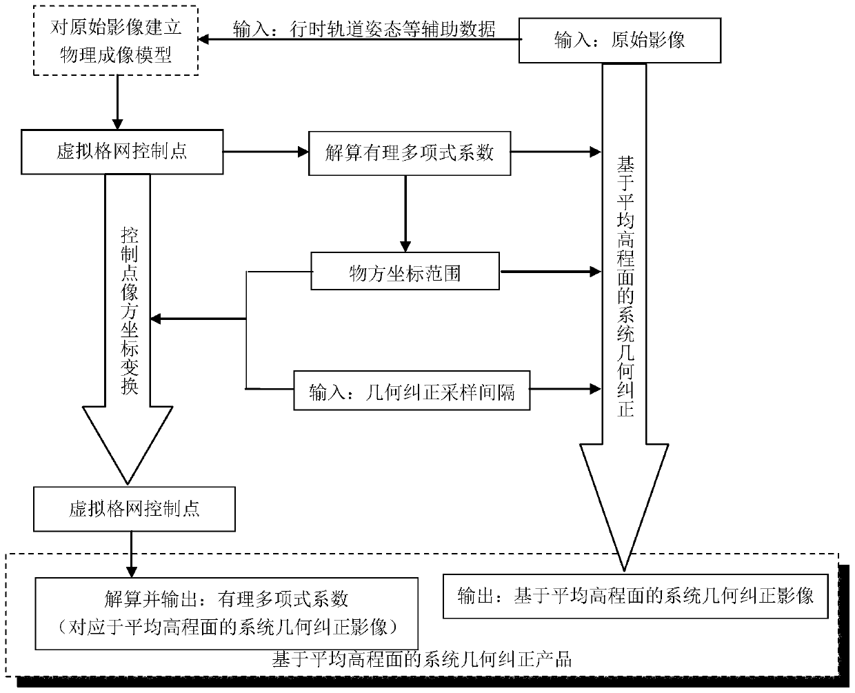
[0039] The present invention mainly comprises:

[0040] Step 1. The image is acquired by the optical sensor of the earth observation satellite through the linear array push-broom imaging method, and the image is corrected by the sensor; at the same time, the sensor correction is calculated by using the auxiliary data such as travel time, attitude, orbit, etc. during the imaging process and the camera calibration coefficient Rational polynomial model coefficients corresponding to the image; Among them, the rational polynomial model corresponding to the sensor correction image refers to the relationship between the two-dimensional coordinates (x, y) of the sensor image point and the three-dimensional coordinates (L, B, H) of the earth surface point Mathematical relation, the specific form of the mathematical relation is the ratio of two cubic polynomials, so it is called favorable polynomial;

[0041] Step 2. Convert the rational polynomial model coefficients corresponding to th...


PUM


Abstract

The invention relates to an average elevation plane-based image rapid geometric preprocessing method. According to the method, two steps of sensor correction and system geometric correction are integrated, and only one system geometric correction product based on an average elevation plane is output. The product has the characteristics of a sensor correction product and a system geometry correction product, and comprises an image with geographic positioning information and a rational polynomial model coefficient. On one hand, the image contains geographic positioning information and can be directly used as a system geometric correction product; and on the other hand, the user can also use the rational polynomial model coefficient to carry out geometric finishing on the image to obtain an image product containing geographic positioning information. According to the image rapid geometric preprocessing system based on the average elevation plane, CPU and I / O resources are saved, the timeliness is improved, and the usability of a product is also improved.

Description

technical field [0001] The invention relates to a preprocessing method, in particular to an image rapid geometric preprocessing method based on an average elevation plane. Background technique [0002] The production process of the traditional ground pretreatment system includes two steps of sensor calibration and system geometry correction, which can output two kinds of images of sensor calibration products and system geometry correction products respectively. Among them, the geometric correction product of the system contains geolocation information, which can be directly used by users. The sensor corrects the coefficients of the rational polynomial model of the product, and the user can perform geometric refinement on the image to obtain an image product containing geographic positioning information. Because this traditional ground pretreatment system needs to output two kinds of products, it increases the I / O overhead and reduces the timeliness, making it difficult to a...

Claims


Application Information

Patent Timeline
IPC IPC(8): G06T5/00
CPCG06T2207/10032G06T5/80
Inventor 金淑英王密张致齐杨芳刘思远
Owner WUHAN UNIV
Why Eureka
Try Eureka