
Unmanned aerial vehicle mountainous region priority rescue path planning method

A path planning, UAV technology, applied in vehicle position/route/altitude control, non-electric variable control, instruments, etc., can solve the problem that UAV path planning cannot perform priority rescue, etc., to improve rescue efficiency and accuracy degree of effect

Active Publication Date: 2020-07-17
GUANGXI TEACHERS EDUCATION UNIV
View PDF11 Cites 2 Cited by
  • Summary
  • Abstract
  • Description
  • Claims
  • Application Information

AI Technical Summary

Problems solved by technology

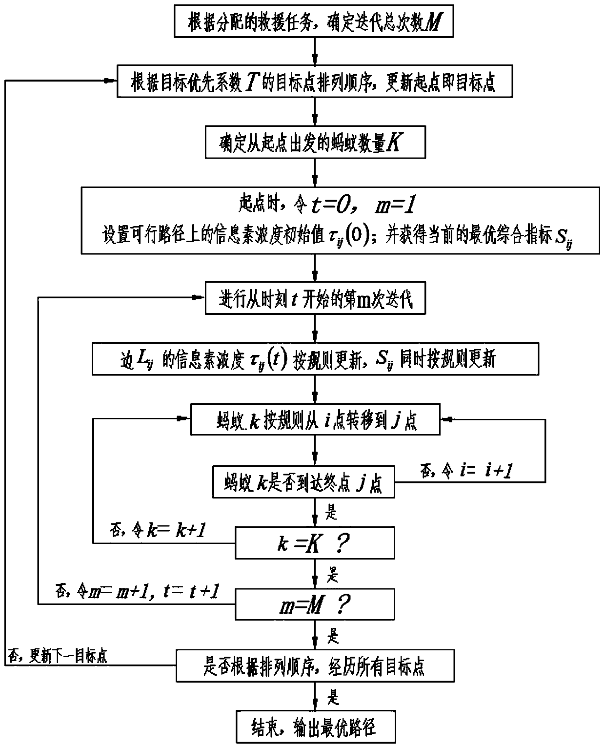
[0006] An object of the present invention is to provide a method for planning priority rescue paths for unmanned aerial vehicles in mountainous areas. Aiming at the problem that prior art path planning for unmanned aerial vehicles cannot perform priority rescue, it proposes to start with the target point with the highest target priority coefficient T The starting point is to find the target point with the highest priority coefficient T of the next target, so that the rescue path starts from the target with the highest priority coefficient T. Through the improved ant colony algorithm search, it is possible to find the critical target with high threat for rescue faster

Method used


Image

  • Unmanned aerial vehicle mountainous region priority rescue path planning method
  • Unmanned aerial vehicle mountainous region priority rescue path planning method
  • Unmanned aerial vehicle mountainous region priority rescue path planning method

Examples


Embodiment Construction

[0044] The present invention will be further described in detail below in conjunction with the accompanying drawings, so that those skilled in the art can implement it with reference to the description.

[0045] It should be understood that terms such as "having", "comprising" and "including" used herein do not exclude the presence or addition of one or more other elements or combinations thereof.

[0046] In one technical solution, the UAV mountain priority rescue path planning method includes:

[0047] Obtain the target position that needs to be rescued, and use the line segment of the Thiessen polygon generated by the target position range based on the obstacle point as the feasible solution of the initial flight path;

[0048] Construct path safety constraints, and select the edge L of Thiessen polygon that satisfies the safety constraints for the feasible solution ij , side L ij is the edge between adjacent vertices i and j of the Thiessen polygon, i and j are two posit...


PUM


Abstract

The invention discloses an unmanned aerial vehicle mountainous region priority rescue path planning method. The method comprises the steps of screening the edge Lij of a Thiessen polygon meeting the safety constraint condition out from a feasible solution of a target position; acquiring the type of an emergency situation to be rescued, wherein the type comprises the number g of people at a targetrescue point and the mountain danger degree h of the target rescue point; constructing a target priority coefficient T related to the threat degree un; at the edge Lij, taking a target point with thehighest target priority coefficient T as a starting point; taking the starting point as the starting point of the ant colony; solving the moving path of the second target point with the highest targetpriority coefficient T through an improved ant colony algorithm; taking the second target point as a new starting point, repeatedly operating the improved ant colony algorithm to solve the moving path of the third target point with the highest next target priority coefficient T until all the target points are passed, and obtaining a total moving path as a priority rescue path. According to the path provided by the invention, the emergency target with high threat degree can be found more quickly for priority rescue.

Description

technical field [0001] The invention relates to the field of unmanned aerial vehicles. More specifically, the present invention relates to a method for planning a UAV mountain priority rescue path. Background technique [0002] In recent years, as an emerging application platform, unmanned aerial vehicles (UAVs) have been widely used in military and civilian fields such as reconnaissance and the environment because of their small size, strong mobility, flexible operation, and low cost. The biggest advantage of man-machines is that they can travel farther, and under the premise of sufficient power, they can greatly extend their voyage time, and can perform more dangerous tasks, reduce the risk factor of personnel, and save costs; therefore, drones are used in personnel search and rescue tasks The application prospect is very broad. [0003] Today's drones are facing many problems that need to be solved urgently in the execution of personnel search and rescue missions, the f...

Claims


Application Information

Patent Timeline
Patent Type & Authority Applications(China)
IPC IPC(8): G05D1/10
CPCG05D1/101Y02T10/40
Inventor 潘颖黄青蓉李雄蒋雪玲
Owner GUANGXI TEACHERS EDUCATION UNIV
Learn More