Remote universal geological compass, equipment and storage medium

A geological and remote technology, applied in the directions of compass, electromagnetic wave re-radiation, satellite radio beacon positioning system, etc., can solve the problems of rock stratum trend error, inability to contact the geological occurrence surface, and inability to measure equipment, so as to improve work efficiency. Efficiency, avoid the effect of manual leveling

Inactive Publication Date: 2020-08-07
CHINA WATER RESOURCES PEARL RIVER PLANNING SURVERYING & DESIGNING
View PDF7 Cites 1 Cited by
  • Summary
  • Abstract
  • Description
  • Claims
  • Application Information

AI Technical Summary

Problems solved by technology

[0002] The traditional electronic compass measurement needs to find the direction of the rock formation and then measure it. Otherwise, the measured direction of the rock formation will have a large error. Although some electronic compasses have inclination compensation calculations, they still have large errors when the inclin...

Method used


Image

  • Remote universal geological compass, equipment and storage medium
  • Remote universal geological compass, equipment and storage medium
  • Remote universal geological compass, equipment and storage medium

Examples


Embodiment Construction

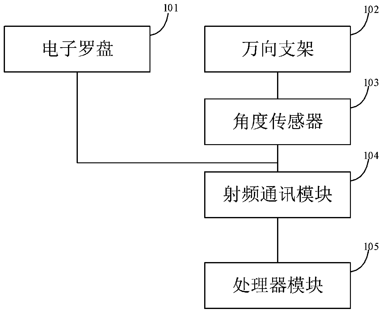
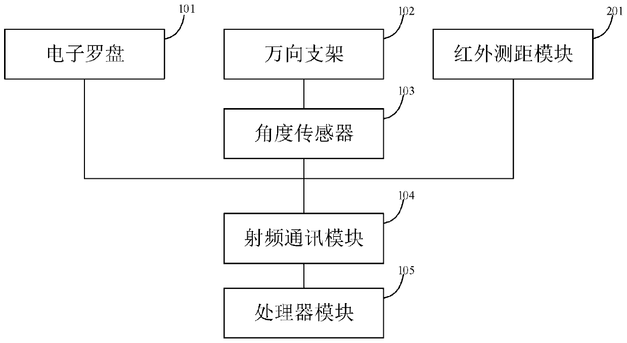
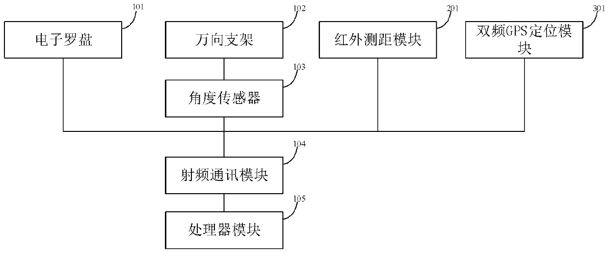
[0029] In order to make the purpose, technical solutions and advantages of the embodiments of the present invention clearer, the technical solutions in the embodiments of the present invention will be clearly and completely described below in conjunction with the drawings in the embodiments of the present invention. Obviously, the described embodiments It is a part of embodiments of the present invention, but not all embodiments. Based on the embodiments of the present invention, all other embodiments obtained by persons of ordinary skill in the art without making creative efforts belong to the protection scope of the present invention. In addition, the technical features in each embodiment or a single embodiment provided by the present invention can be combined arbitrarily with each other to form a feasible technical solution, but it must be based on the realization of those skilled in the art. When there is a contradiction or cannot be realized, it should be considered that ...


PUM


Abstract

The embodiment of the invention provides a remote universal geological compass and equipment. The system comprises an electronic compass which is connected with a radio frequency communication moduleand is used for acquiring azimuth information; a universal support, wherein each rotating shaft of the universal support is provided with an angle sensor which is used for calculating the angle between the measured geological interface and the horizontal plane; a radio frequency communication module which is connected with the processor module and used for sending direction information of the electronic compass and angle change information of the angle sensor to the processor module; an infrared distance measuring module which is used for determining the distance and space relationship betweenthe non-contact geological interface and the electronic compass and converting the angle between the non-contact geological interface and the horizontal plane. According to the remote universal geological compass and equipment provided by the embodiment of the invention, the occurrence terrain of a remote geological interface can be measured, the manual leveling can be avoided, and the working efficiency is remarkably improved.

Description

technical field [0001] Embodiments of the present invention relate to the field of compass technology, and in particular to a remote universal geological compass, equipment and storage media. Background technique [0002] The traditional electronic compass measurement needs to find the direction of the rock formation and then measure it. Otherwise, the measured direction of the rock formation will have a large error. Although some electronic compasses have inclination compensation calculations, they still have a large error when the inclination angle is large. According to the actual measurement of the mobile phone, The measurement error is 10° to 20°. Secondly, in the implementation process of some geological surveying and mapping, it is often encountered that the geological occurrence surface cannot be touched, and the existing equipment cannot be used for measurement. Therefore, developing a remote universal geological compass that can effectively overcome the defects in...

Claims


Application Information

Patent Timeline
IPC IPC(8): G01C17/00G01C1/00G01S17/08G01S19/42
CPCG01C17/00G01C1/00G01S17/08G01S19/42
Inventor 曾伟国陈杰吴飞金丹李振嵩张小平张浩然
Owner CHINA WATER RESOURCES PEARL RIVER PLANNING SURVERYING & DESIGNING
Why Eureka
Try Eureka