A Laser Pointing On-orbit Calibration Method Based on Spaceborne Laser Monolithic Footprint Image

A laser pointing and laser technology, applied in the re-radiation of electromagnetic waves, instruments, measuring devices, etc., can solve the problems of low success rate, large manpower and material resources, imaging difficulties, etc., achieving low cost investment, high success rate, and improved geometric positioning. The effect of precision

Active Publication Date: 2021-03-12
自然资源部国土卫星遥感应用中心
View PDF8 Cites 0 Cited by
  • Summary
  • Abstract
  • Description
  • Claims
  • Application Information

AI Technical Summary

Problems solved by technology

Each method has its own advantages and disadvantages. The ground detector calibration method has a high success rate and high precision, but requires a lot of manpower and material resources.
The accuracy of the airborne infrared camera imaging calibration method is high, but the imaging is difficult due to the low attenuation of the laser energy when it reaches the surface. At the same time, it is difficult to control the synchronous transit time of the satellite and the aircraft, and the success rate is low.
The method of terrain matching does not require field operations, but requires hundreds of kilometers of high-precision terrain data. Large-scale high-precision terrain data is very expensive, and it is costly to carry out calibration tests.

Method used


Image

  • A Laser Pointing On-orbit Calibration Method Based on Spaceborne Laser Monolithic Footprint Image
  • A Laser Pointing On-orbit Calibration Method Based on Spaceborne Laser Monolithic Footprint Image
  • A Laser Pointing On-orbit Calibration Method Based on Spaceborne Laser Monolithic Footprint Image

Examples


Embodiment Construction

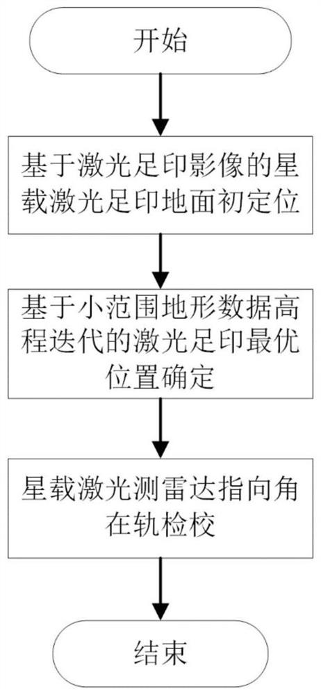
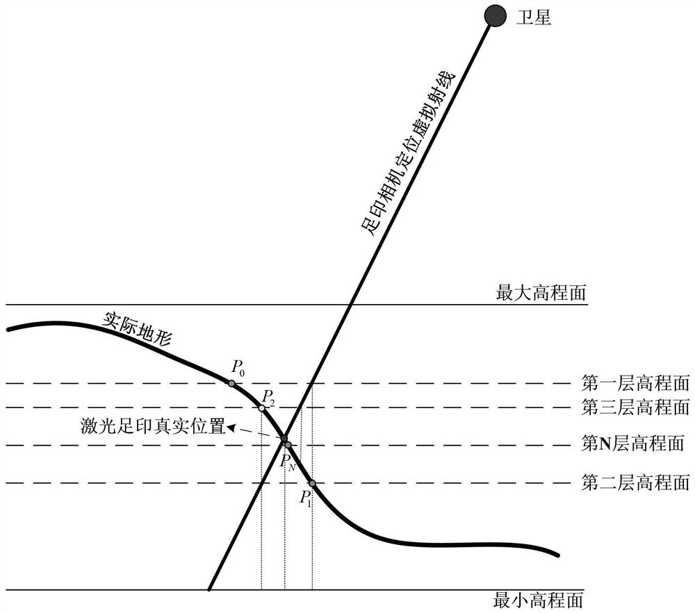
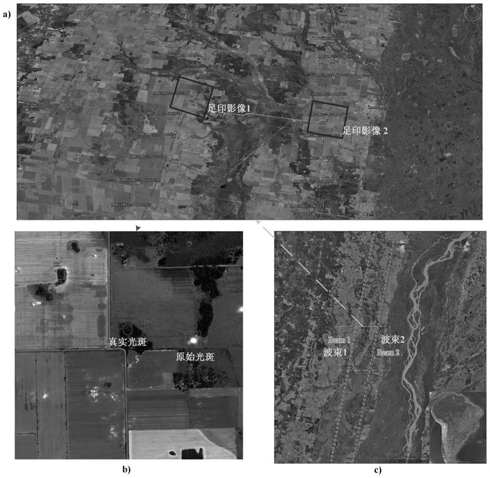
[0017] In order to make the object, technical solution and advantages of the present invention clearer, the present invention will be further described in detail below in conjunction with the embodiments and accompanying drawings. According to the basic characteristics of the space-borne lidar system equipped with footprint cameras, the present invention, during the operation of the satellite in orbit, while the laser is observing the earth, the footprint cameras are synchronously turned on to capture laser footprints, and the laser footprint image and small-scale terrain are obtained The data quickly determines the centroid position of the laser ground footprint, which is used as the ground reference control of the present invention.

[0018] Such as figure 1 As shown, the laser pointing on-orbit calibration method based on the spaceborne laser monolithic footprint image proposed by the present invention specifically includes the following steps:

[0019] Step 1. Initial gro...


PUM


Abstract

The invention discloses a laser pointing on-orbit calibration method based on a satellite-borne laser monolithic footprint image. The method comprises the following steps of initially positioning theground position of a satellite-borne laser footprint; based on the topographic data, rapidly determining the optimal position coordinates of the satellite-borne laser footprint ground by adopting an elevation hierarchical iteration method; and solving a laser pointing angle by using the optimal position coordinate of the satellite-borne laser footprint ground. The invention discloses a specific implementation process and a resolving process for initially positioning a laser footprint based on a satellite-borne footprint image, iteratively determining an optimal position of the satellite-bornelaser footprint by depending on small-range high-precision topographic data, and calibrating the laser pointing angle based on the optimal position of the laser footprint determined by the footprint image. According to the invention, the large-area high-precision topographic data is not needed, and detectors are not arranged on the ground, so that the consumption of capital and human resources caused by purchasing topographic data and field calibration can be greatly reduced, and the field operation cost is greatly reduced.

Description

technical field [0001] The invention relates to the technical field of on-orbit geometric calibration of space-borne laser radar, in particular to an on-orbit calibration method of laser pointing based on a single footprint image of a space-borne laser. Background technique [0002] Geometric positioning accuracy is the most important indicator to measure the performance of domestic surveying and mapping satellites, among which elevation accuracy is more important because it is difficult to improve. LiDAR (Light Detection And Ranging, referred to as LiDAR) has the characteristics of good directionality, high coherence, good monochromaticity, and high ranging accuracy. Now there are GLAS (Geoscience Laser Altimeter System), ATLAS (The Advanced Topographic Laser Altimeter System, ATLAS) is used for earth observation. Space-borne lidar has shown great application potential in the fields of deep space exploration and earth science. Space-borne laser altimetry technology is appli...

Claims


Application Information

Patent Timeline
Patent Type & Authority Patents(China)
IPC IPC(8): G01S7/497G01S17/88
CPCG01S7/497G01S17/88
Inventor 谢俊峰唐新明莫凡刘仁刘力荣褚存
Owner 自然资源部国土卫星遥感应用中心
Why Eureka
Try Eureka