A method for on-orbit joint calibration of multi-beam spaceborne laser altimeter

A laser altimeter and multi-beam technology, which is used in the re-radiation of electromagnetic waves, radio wave measurement systems, instruments, etc. Method introduction, beam system error, etc.

Active Publication Date: 2021-03-30
自然资源部国土卫星遥感应用中心
View PDF10 Cites 0 Cited by
  • Summary
  • Abstract
  • Description
  • Claims
  • Application Information

AI Technical Summary

Problems solved by technology

However, due to the fact that the laser altimeter will produce many system errors such as pointing angle, centroid offset, and system clock synchronization during the measurement process, especially the pointing angle error, it may reduce the accuracy of the laser footpoint as the height control of the surveying and mapping industry.
Taking the influence of laser pointing angle error as an example, for an altimetry system with an orbital height of 500km, when the surface incident angle is 1°, a 30″ laser pointing error causes a horizontal error of 75m and a height error of 1.3m for the foot point positioning, while for multi- Beam spaceborne laser altimeter, when there is an error in the pointing of a certain beam, it may cause a certain systematic error in all beams of the entire system
[0004] At present, the calibration methods of spaceborne laser altimeters for earth observation are mainly single-beam spaceborne laser altimeters, and there is no introduction of on-orbit calibration methods for multi-beam spaceborne laser altimeters

Method used


Image

  • A method for on-orbit joint calibration of multi-beam spaceborne laser altimeter
  • A method for on-orbit joint calibration of multi-beam spaceborne laser altimeter
  • A method for on-orbit joint calibration of multi-beam spaceborne laser altimeter

Examples


Embodiment Construction

[0016] In order to make the object, technical solution and advantages of the present invention clearer, the present invention will be further described in detail below in conjunction with the embodiments and accompanying drawings.

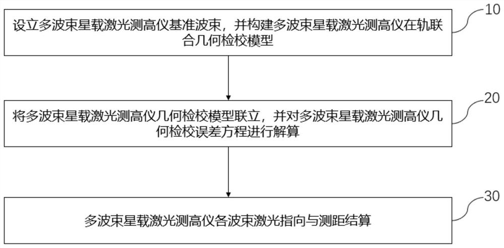
[0017] This embodiment provides a method for on-orbit joint calibration of multi-beam spaceborne laser altimeters. On the basis of setting up reference beams, the ground three-dimensional coordinates of the laser spots of each beam obtained in advance are taken as known data into the constructed The multi-beam spaceborne laser altimeter is in the on-orbit calibration model, so that the beam pointing and ranging calibration of the reference beam 1 to beam N can be performed. During specific implementation, automatic operation and processing can be realized through computer software technology.

[0018] Such as figure 1 As shown, the on-orbit joint calibration process of the multi-beam spaceborne laser altimeter includes the following steps:

[001...


PUM


Abstract

The invention discloses an on-orbit joint calibration method for a multi-beam satellite-borne laser altimeter. According to the method, a relative geometrical relationship between a reference beam andother beams is constructed by setting a reference beam, so that a multi-beam laser combined geometric calibration model is established. The method comprises the steps of setting a reference beam of the multi-beam satellite-borne laser altimeter, and constructing an on-orbit combined geometrical calibration model of the multi-beam satellite-borne laser altimeter; combining the geometric calibration models of the multi-beam satellite-borne laser altimeter, and resolving a geometric calibration error equation of the multi-beam satellite-borne laser altimeter; and performing laser pointing and ranging settlement on each beam of the multi-beam satellite-borne laser altimeter. The technical scheme of the invention aims to solve the problem of on-orbit calibration of the multi-beam satellite-borne laser altimeter, and provides a reliable on-orbit calibration method for the multi-beam satellite-borne laser altimeter which is already on orbit and is about to be launched at present.

Description

technical field [0001] The invention relates to the technical field of on-orbit geometric calibration of a spaceborne multi-beam laser altimeter, in particular to an on-orbit multi-beam spaceborne laser altimeter for high-precision geometric positioning of each beam of a multi-beam spaceborne laser altimeter joint calibration method. Background technique [0002] Geometric positioning accuracy is the most important index to measure the performance of surveying and mapping satellites, among which elevation accuracy is more important because it is difficult to improve. LiDAR (Light Detection And Ranging, referred to as LiDAR) has the characteristics of good directionality, high coherence, good monochromaticity, and high ranging accuracy. It has great application potential in the fields of deep space exploration and earth science. Onboard laser altimetry technology is applied to high-resolution optical three-dimensional surveying and mapping satellites, assisting space photogr...

Claims


Application Information

Patent Timeline
Patent Type & Authority Patents(China)
IPC IPC(8): G01S17/08G01S7/497
CPCG01S7/497G01S17/08
Inventor 唐新明谢俊峰刘仁莫凡窦显辉朱广彬欧阳斯达
Owner 自然资源部国土卫星遥感应用中心
Why Eureka
Try Eureka