Coal mine visual management and control system based on temporal GIS

A coal mine and temporal technology, which is applied in the field of coal mine visualization management and control system based on temporal GIS, can solve the problems of inability to meet precise mining, unfavorable spatial analysis and intelligent decision-making, and inability to express the real geographical, spatial and temporal mining environment of the spatial location of production equipment, etc. Achieve the effect of improving coal mine safety level, good promotion value, and reducing operating personnel and operating time

Active Publication Date: 2020-08-11
BEIZHING LONGRUAN TEKNOLODZHIS INK
View PDF7 Cites 6 Cited by
  • Summary
  • Abstract
  • Description
  • Claims
  • Application Information

AI Technical Summary

Problems solved by technology

[0003] The existing coal mine automatic mining management and control platform is mainly constructed with the help of industrial configuration software. It is developed based on the dynamic rendering of simulated schematic diagrams or Flash animation technology. It has the characteristics of simulating equipment actions, but it cannot express the spatial position and The installed real geographical space-time mining environment lacks the support of geographical space space-time relationship, and cannot provide immersive control experience and integration with GIS thematic graphics, which is not conducive to spatial analysis and intelligent decision-making. Therefore, this system is not very good It meets the needs of intelligent coal mine mining with few or no people, and it cannot meet the higher requirements of precise mining

Method used


Image

  • Coal mine visual management and control system based on temporal GIS
  • Coal mine visual management and control system based on temporal GIS

Examples


Embodiment Construction

[0035] In order to make the above objects, features and advantages of the present invention more comprehensible, the present invention will be further described in detail below in conjunction with the accompanying drawings and specific embodiments.

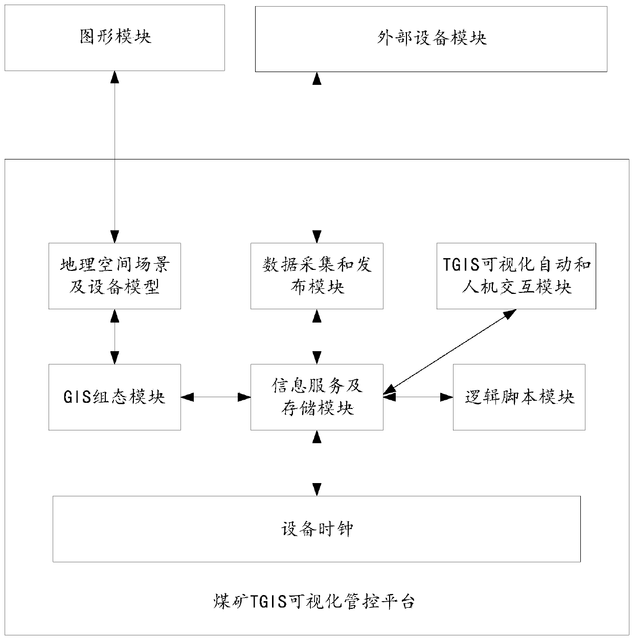
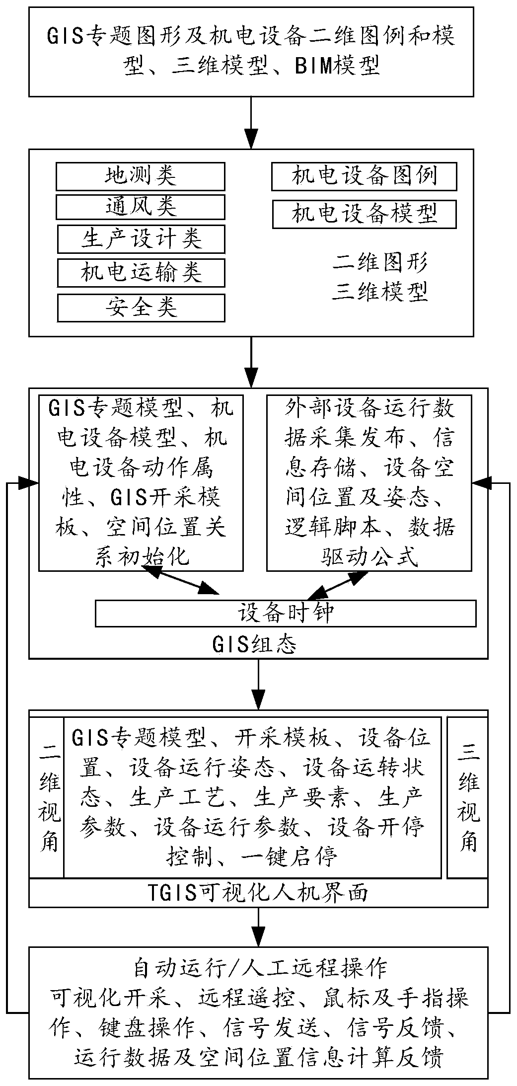
[0036] The present invention can realize the two-dimensional and three-dimensional visualized space information fusion expression of all elements of the geological model and equipment model in the coal mining area, realize the construction of the geological model and equipment model and the attribute design and action association of data-driven components, and truly express the coal mine The geological template of the dangerous mining area and the spatial position and posture during the operation of the equipment; provide a remote intelligent mining control method based on the 2D and 3D GIS visualization interface, and the operator can achieve the same effect as the on-site operation through remote control, reducing the number of op...


PUM


Abstract

The invention provides a coal mine visual management and control system based on a temporal GIS. The coal mine visual management and control system comprises a coal mine TGIS visual management and control platform, a graphic module and an external equipment module. The graph module is used for drawing, editing, storing, importing and exporting a coal mine GIS thematic graph and an equipment model;the external equipment module is coal mine electromechanical equipment and control peripheral equipment, and is used for acquiring sensor data and communicating with the coal mine TGIS visual management and control platform; the coal mine TGIS visual management and control platform is used for importing graphs and models drawn by the graph module; a continuous, dynamic and traceable coal mining visual scene is constructed in combination with a production process, production elements and operation state information of external equipment, two production modes of full-automatic and manual remoteintervention are realized, operators and operation time in a dangerous area of a coal mine are reduced, and the intelligent level of coal mine safety production is improved.

Description

technical field [0001] The invention relates to the technical field of coal mine production, in particular to a coal mine visualization management and control system based on temporal GIS. Background technique [0002] In the process of digital coal mine or intelligent coal mine construction, it is an inevitable demand for the modernization of coal mines to realize the remote control of underground electromechanical equipment in order to achieve the purpose of reducing staff, increasing efficiency and ensuring safety. [0003] The existing coal mine automatic mining management and control platform is mainly constructed with the help of industrial configuration software. It is developed based on the dynamic rendering of simulated schematic diagrams or Flash animation technology. It has the characteristics of simulating equipment actions, but it cannot express the spatial position and The installed real geographical space-time mining environment lacks the support of geographic...

Claims


Application Information

Patent Timeline
Patent Type & Authority Applications(China)
IPC IPC(8): G06F16/29G06Q10/06G06Q50/02
CPCG06Q10/0631G06Q50/02G06F16/29
Inventor 毛善君陈华洲张鹏鹏李鑫超王雷朱青陈金川李梅
Owner BEIZHING LONGRUAN TEKNOLODZHIS INK
Why Eureka
Try Eureka