
Rational polynomial coefficient-based single satellite-borne remote sensing image target height calculation method

A technology of rational polynomial and calculation method, which is applied in the field of target height calculation based on rational polynomial coefficients of a single satellite-borne remote sensing image, can solve the problem that the height calculation result has a great influence on the accuracy of the result, is difficult to obtain, and does not provide image imaging satellite altitude and sun. Height angle etc.

Active Publication Date: 2020-08-28
AEROSPACE INFORMATION RES INST CAS
View PDF8 Cites 3 Cited by
  • Summary
  • Abstract
  • Description
  • Claims
  • Application Information

AI Technical Summary

Problems solved by technology

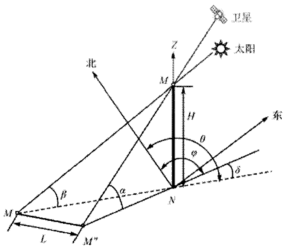
[0016] (1) The existing calculation method for the height of a single remote sensing image needs to know the altitude angle of the satellite and the sun when the remote sensing image is formed. In the actual process, it is difficult to obtain these two angles. satellite altitude angle and sun altitude angle;
[0017] (2) Use the trigonometric function relationship to calculate the target altitude. The angle accuracy has a great influence on the accuracy of the altitude calculation result, and the accuracy of the satellite and sun altitude angles at the imaging time given by satellite remote sensing products cannot be guaranteed. Therefore, using the sun altitude angle and satellite altitude angle The method cannot obtain satisfactory height solution results

Method used


Image

  • Rational polynomial coefficient-based single satellite-borne remote sensing image target height calculation method
  • Rational polynomial coefficient-based single satellite-borne remote sensing image target height calculation method
  • Rational polynomial coefficient-based single satellite-borne remote sensing image target height calculation method

Examples


Embodiment Construction

[0060] In order to make the purpose, technical solutions and advantages of the present invention clearer, the present invention will be further described in detail below in conjunction with specific embodiments and with reference to the accompanying drawings.

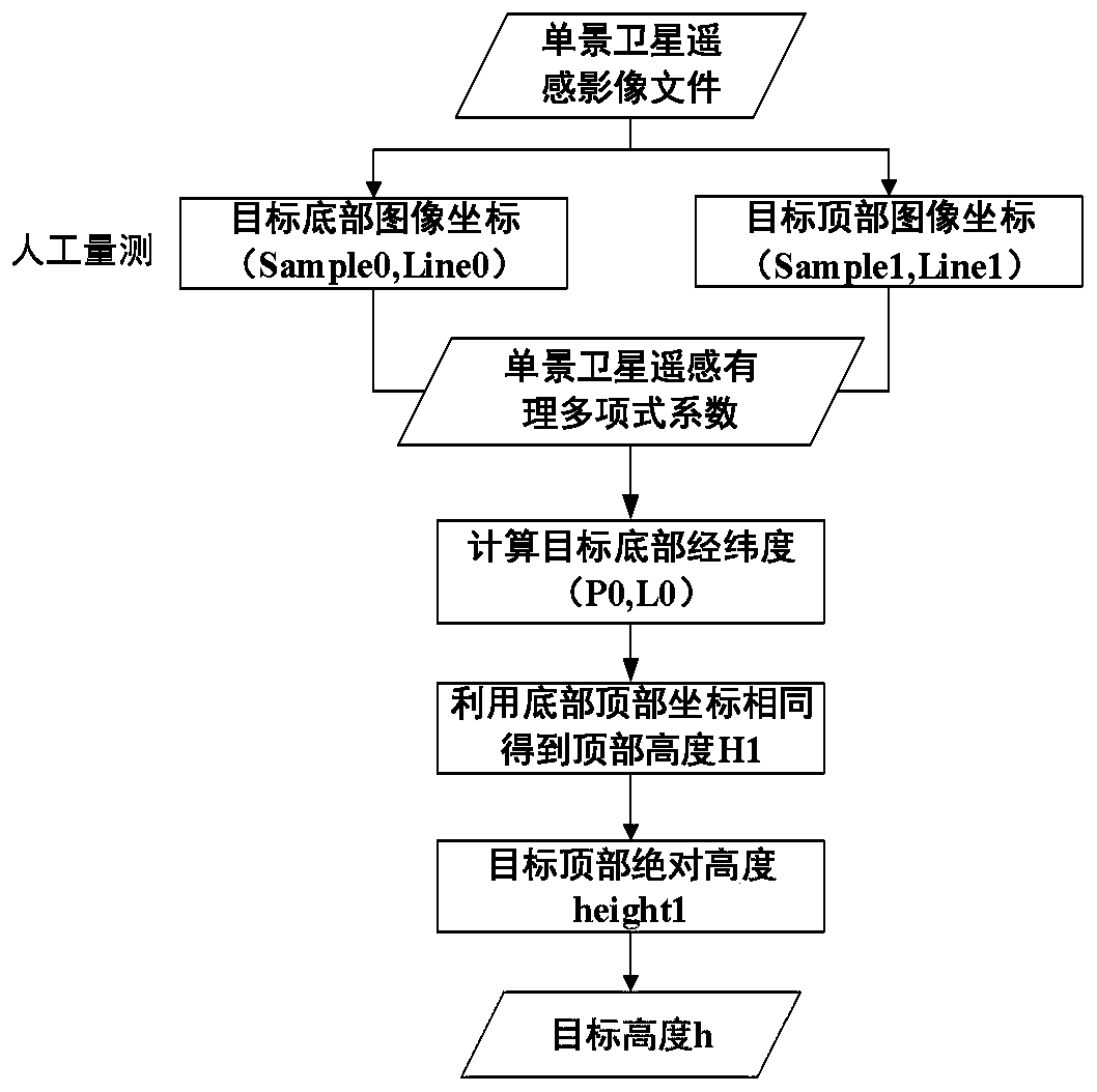
[0061] Aiming at the determination of the existing technical solutions, the present invention proposes a method for calculating the target height of a single spaceborne remote sensing image based on rational polynomial coefficients. The method has the advantages of: 1) using the rational polynomial coefficients of the remote sensing image to calculate the target height , does not need satellite altitude angle and sun altitude angle information at the imaging moment; 2) Taking the same longitude and latitude information at the bottom and top of the target as a constraint, construct a single remote sensing image target height calculation method based on rational polynomial coefficients. The calculation process only needs to...


PUM


Abstract

The invention discloses a rational polynomial coefficient-based single satellite-borne remote sensing image target height calculation method. The rational polynomial coefficient-based single satellite-borne remote sensing image target height calculation method comprises the following steps of obtaining a bottom coordinate and a top coordinate of a target on a remote sensing image; determining a relationship between original data image plane coordinates and ground three-dimensional coordinates through rational polynomial coefficients; expressing target bottom coordinates in a form of the rational polynomial coefficients; expressing the top coordinates of the target in the form of rational polynomial coefficients; directly solving the top height of the regularized target based on the featurethat the bottom longitude and latitude of the target are consistent with the top longitude and latitude; performing inverse transformation by adopting a regularization formula to obtain a target topabsolute height; and performing difference between the target top height and the bottom height to obtain a target height. The rational polynomial coefficient-based single satellite-borne remote sensing image target height calculation method does not need to use a spatial triangular relation between a satellite or the sun and a target, is higher in calculation precision, and directly observes the target body while shadow information of the target is not needed, and the calculation process is simple, convenient and efficient.

Description

technical field [0001] The invention relates to the technical field of spaceborne remote sensing images, in particular to a method for calculating the target height of a single spaceborne remote sensing image based on rational polynomial coefficients. Background technique [0002] With the rapid development of urban processes, there are more and more man-made buildings. Different from the gradual shape of naturally formed objects, man-made objects generally have the characteristics of vertical erection, such as buildings, monuments, towers, transmission poles, etc. For the height information of vertical targets, it is more difficult to measure manually on site. Accurate, objective and rapid acquisition of vertical target height information can be achieved by using space-borne remote sensing images. [0003] The existing target height calculation methods based on a single satellite remote sensing image generally use the target shadow length, sun altitude angle and azimuth a...

Claims


Application Information

Patent Timeline
Patent Type & Authority Applications(China)
IPC IPC(8): G06F17/10G01C5/00
CPCG06F17/10G01C5/00
Inventor 王峰胡玉新尤红建
Owner AEROSPACE INFORMATION RES INST CAS
Learn More