

Method and system for intelligent assimilation of spatial and temporal information of multi-source heterogeneous data of natural resources
A technology for multi-source heterogeneous data and natural resources, applied in the direction of structured data retrieval, structured data browsing, database update, etc.
Active Publication Date: 2020-09-18
珠海市测绘院 +1
View PDF6 Cites 7 Cited by
- Summary
- Abstract
- Description
- Claims
- Application Information
AI Technical Summary
Problems solved by technology
[0003] The present invention provides a system and method for intelligent assimilation of spatio-temporal information of multi-source heterogeneous data for natural resources, which is used to meet the needs of scientific and efficient unified management of natural resources, and solve the problem of the wide range of natural resources and the scattered and complex data information in the prior art. , different data standards, different depths of content expression, lack of connection between data, inconsistent and changeable surveying and mapping business rules, low automation of cross-platform, complex multi-source
Method used
View moreImage
Smart ImageViewing Examples

Examples
 PUM
 Abstract
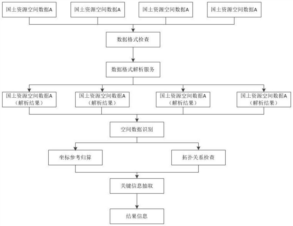
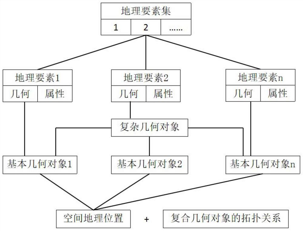
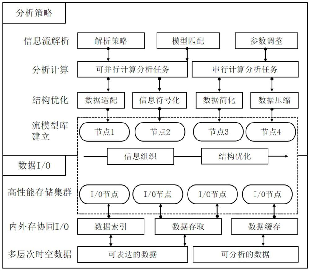
The invention discloses a method and a system for the intelligent assimilation of the spatial and temporal information of multi-source heterogeneous data of natural resources. The method comprises thefollowing steps: S1, checking and analyzing a data format; s2, spatial data recognition; s3, extracting key information; s4, displaying a result; s5, establishing indexes. According to the invention,natural resources in the prior art are involved widely; data information dispersion and complexity, data standard inconsistency, content expression depths differing, data is lack of connection and surveying and mapping business rules are not unified and changeable; the problem of low automation degree of cross-platform and complex multi-source heterogeneous data processing is solved; the backwardtechnical form of surveying and mapping production is improved; the problems of repeated surveying and mapping, difficult big data mining, difficult cooperative service, multiple business surveying and mapping geographic information service types under a natural resource system, complex information flow and the like due to non-uniform surveying and mapping service specifications and disjunction of data products and requirements are solved, and then support and service are provided for a high-efficiency on-demand surveying and mapping geographic information technology.
Description
technical field [0001] This application relates to the technical field of surveying and mapping geographic information, in particular to a method and system for intelligent assimilation of spatio-temporal information of multi-source heterogeneous data of natural resources. Background technique [0002] Surveying and mapping geographic information can support the scientific and efficient development of unified management of natural resources. However, natural resources involve a wide range of areas, data information is scattered and complex, data standards are different, content expression depth is different, and data is lack of connection; at the same time, surveying and mapping business rules are not uniform and changeable, cross-platform, complex and multi-source The degree of automation of data processing is low, and the form of surveying and mapping production technology is backward; the specifications of surveying and mapping services are not uniform, data products are ...
Claims
Login to View More Application Information
Patent Timeline
 IPC IPC(8): G06F16/21G06F16/29G06F16/26G06F16/23
CPCG06F16/21G06F16/29G06F16/26G06F16/23
Inventor李旺民贠法长何福久李进禄黎彬马德富丁建勋高春辉冯琰路志越何冰
Owner珠海市测绘院