Spatial data indexing method integrating GeoHash and Quadtree

A spatial data and indexing technology, applied in database indexing, structured data retrieval, digital data information retrieval, etc., can solve problems such as difficulty in supporting concurrent updates, drastic changes in index structure, and inability to meet actual needs in dynamic update performance. The effect of data management efficiency

Active Publication Date: 2020-09-29
CHONGQING ACAD OF METROLOGY & QUALITY INST
View PDF8 Cites 3 Cited by
  • Summary
  • Abstract
  • Description
  • Claims
  • Application Information

AI Technical Summary

Problems solved by technology

[0004] For the inherent top-down update mode of the existing index structure, the necessary index page disk I / O is required to access the data page where the spatial object is located. If it is used to manage massive and frequently updated spatial data, the index structure will be violent. changes, resulting in a large I / O cost, and the characteristics of being difficult to support concurrent updates, so in many applications its dynamic update performance often cannot meet the technical problems of actual needs. The present invention provides a spatial data index integrating GeoHash and Quadtree method

Method used


Image

  • Spatial data indexing method integrating GeoHash and Quadtree
  • Spatial data indexing method integrating GeoHash and Quadtree
  • Spatial data indexing method integrating GeoHash and Quadtree

Examples


Embodiment Construction

[0026] In order to make the technical means, creative features, goals and effects achieved by the present invention easy to understand, the present invention will be further described below in conjunction with specific illustrations.

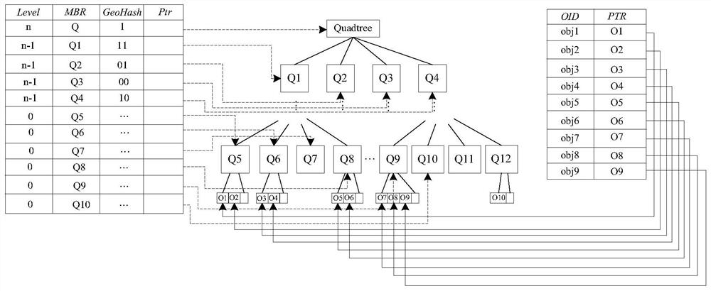
[0027] Please refer to Figure 1 to Figure 4 As shown, the present invention provides a spatial data indexing method integrating GeoHash and Quadtree, said indexing method includes improving quadtree index structure creation and based on bottom-up dynamic update; wherein,

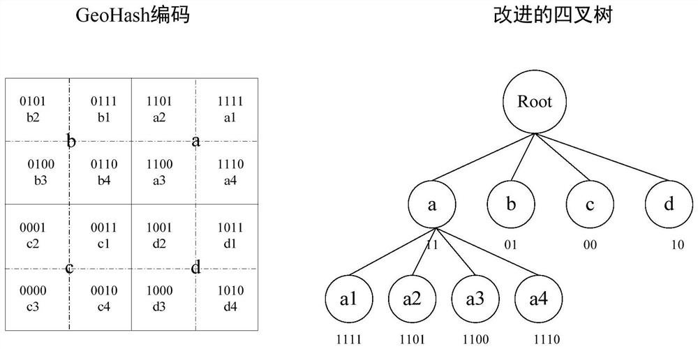
[0028] The improved quadtree index structure created includes an improved quadtree (QG-tree), a direct-access table (direct-access table) and a Hash index table built on top of the spatial object; specifically,

[0029] Such as image 3The existing GeoHash shown is a geocoding format that alternately bisects the Earth's surface along longitude and latitude directions, and uses a single binary number (GeoHash code) to represent the resulting non-overlapping grid, twice for th...


PUM


Abstract

The invention provides a spatial data indexing method integrating GeoHash and Quadtree. The method comprises the steps of creating an improved quadtree index structure and dynamically updating from bottom to top ,wherein the improved quadtree index structure comprises an improved quadtree, a direct access table and a Hash index table established on a space object, the improved quadtree adopts a region division rule based on GeoHash and quadtree similarity, a space region is divided according to the GeoHash, the quadtree with nodes in one-to-one correspondence with GeoHash codes is establishedaccording to a grid, and a direct access table is used for pointing to all intermediate nodes in the improved quadtree; and a corresponding space object record in the improved quadtree leaf child nodeis accessed by using a Hash index table based on a space object identifier based on a bottom-up dynamic updating algorithm, and when the space object sends a position updating request, a plurality ofupdating strategies are adopted according to the position change degree of the space object. According to an improved quadtree index structure, an extended bottom-up dynamic updating algorithm is provided, and frequent updating operation of indexes is supported.

Description

technical field [0001] The invention relates to the technical field of spatial data indexing, in particular to a spatial data indexing method integrating GeoHash and Quadtree. Background technique [0002] Against the backdrop of the rapid development of technologies such as the Internet and GNSS (Global Navigation Satellite System) positioning, the types, scale, and speed of spatial data are increasing rapidly. Massive spatial data must contain a lot of useful information, management and retrieval. These massive spatial data often require a large number of update operations. How to manage these massive spatial data and provide an efficient indexing mechanism for frequently updated massive data is a key problem that needs to be solved urgently. [0003] At present, scholars at home and abroad have proposed many spatial data storage and retrieval methods for this problem, such as the Quad-Tree Index that can continuously divide the spatial range into four equal parts to impro...

Claims


Application Information

Patent Timeline
Patent Type & Authority Applications(China)
IPC IPC(8): G06F16/22G06F16/23G06F16/2458G06F16/29
CPCG06F16/2246G06F16/2255G06F16/23G06F16/2458G06F16/29
Inventor 班亚袁静王锐
Owner CHONGQING ACAD OF METROLOGY & QUALITY INST
Why Eureka
Try Eureka