Land utilization classification method for time series remote sensing images

A technology of time series and classification methods, applied in the field of remote sensing image analysis, can solve problems such as hindering the development of classification models and classification effects, hindering the collection of time series remote sensing images, and lack of label samples

Active Publication Date: 2020-10-02
CENT SOUTH UNIV
View PDF5 Cites 19 Cited by
  • Summary
  • Abstract
  • Description
  • Claims
  • Application Information

AI Technical Summary

Problems solved by technology

There are various classification methods based on deep learning, but because such methods usually require rich and diverse sample data for network model training, this increases the difficulty for the collection of long-term remote sensing datasets, especially label data. It is difficult to ensure that each image in the time series has corresponding real surface label data
In addition, the collection of optical remote sensing images is difficult to avoid the situation of cloud and fog occlusion. Due to the inevitability and uncertainty of cloud and fog occlusion, it will also lead to the loss of continuous images, which not only hinders the collection of time series remote sensing images, but also affects the effect of classification and precision
[0003] According to the current research background and technology, for the classification of time series remote sensing data, there are mainly the following problems to be solved: (1) The collection of time series remote sensing data sets is relatively difficult, especially the lack of corresponding label samples in practice, seriously It hinders the development and classification effect of classification models that rely on training samples
(2) The collection of optical remote sensing images is difficult to avoid the situation of cloud and fog occlusion. Due to the inevitability and uncertainty of cloud and fog occlusion, it will also lead to the loss of continuous data, which not only hinders the collection of time series remote sensing images, but also affects the classification. effect and precision

Method used


Image

  • Land utilization classification method for time series remote sensing images
  • Land utilization classification method for time series remote sensing images
  • Land utilization classification method for time series remote sensing images

Examples


Embodiment Construction

[0034] The present invention will be further described below in conjunction with the embodiments and accompanying drawings, but the present invention is not limited in any way. Any transformation or replacement based on the teaching of the present invention belongs to the protection scope of the present invention.

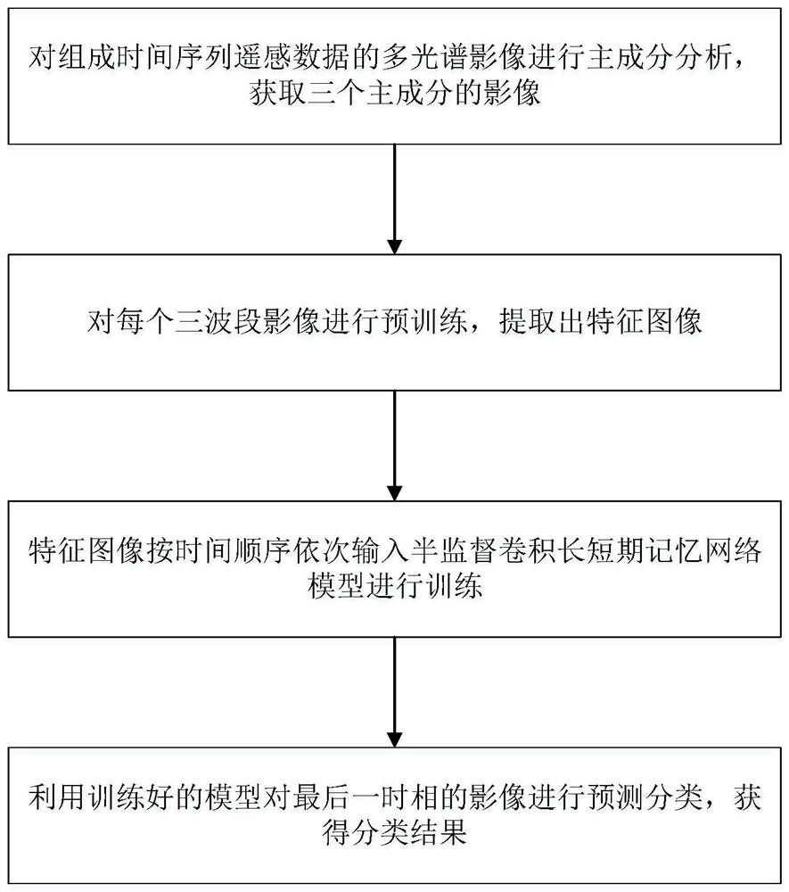
[0035] Such as figure 1 As shown, a land use classification method for time series remote sensing images, including the following steps:

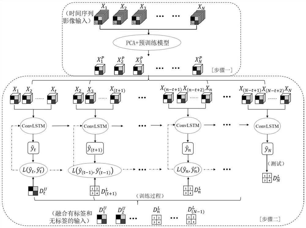
[0036] Step 1, perform principal component analysis on the multispectral images that make up the time series remote sensing data, and obtain images of three principal components;

[0037] Step 2, pre-train each three-band image and extract the feature image;

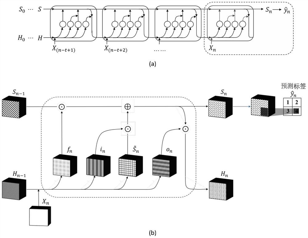
[0038] Step 3, the feature images are sequentially input into the semi-supervised convolutional long-term short-term memory network model in chronological order for training;

[0039] Step 4, use the trained model to predict and classify the images in the last phase, and...


PUM


Abstract

The invention discloses a time sequence remote sensing image-oriented land utilization classification method, and the method comprises the following steps: carrying out principal component analysis onmultispectral images forming time sequence remote sensing data to obtain images of three principal components; pre-training each three-waveband image, and extracting a feature image; sequentially inputting the feature images into a semi-supervised convolution long-term and short-term memory network model for training according to a time sequence; and utilizing the trained model to predict and classify the image of the last time phase to obtain a classification result. According to the invention, time context information of a time sequence and space and spectral characteristic information of aremote sensing image are comprehensively considered; the problems existing in the prior art are well solved by utilizing the pre-training model and the semi-supervised classification learning mode, so the land utilization classification method is more suitable for classification scenes with less training sample data and missing or partially missing remote sensing image data, and a better land utilization classification result is obtained.

Description

technical field [0001] The invention belongs to the technical field of remote sensing image analysis, and relates to a land use classification method for time series remote sensing images. Background technique [0002] With the continuous development of remote sensing technology, increasing multi-source remote sensing data and accumulated historical images make it easier to obtain multi-source, multi-time relative remote sensing data. The continuous development of technology and increasing demand make the image classification technology transform from a single feature to a multi-feature application. Studies in recent years have proved that temporal context features are conducive to improving the accuracy of image classification. For example, Kun J&Shunlin L et al. used time series data to extract and classify forest coverage better than single-temporal classification (references: Jia K, Liang S, Zhang L, et al.Forest cover classification using Landsat ETM+data and time seri...

Claims


Application Information

Patent Timeline
Patent Type & Authority Applications(China)
IPC IPC(8): G06K9/62G06N3/04G06N3/08G06T3/40G06T7/40
CPCG06N3/049G06N3/084G06T3/4007G06T7/40G06T2207/10036G06N3/044G06N3/045G06F18/241G06F18/214
Inventor 陶超沈靖李海峰
Owner CENT SOUTH UNIV
Why Eureka
Try Eureka