Coarse-grained label-guided deep learning method for cloud region detection in pixel-level remote sensing images

A remote sensing image and deep learning technology, applied in the field of remote sensing and artificial intelligence, can solve the problems of time-consuming, labor-intensive, and labor-intensive labeling work, and achieve the effect of reducing the cost of labeling, improving quality, and improving resolution.

Active Publication Date: 2022-04-01
WUHAN UNIV
View PDF10 Cites 0 Cited by
  • Summary
  • Abstract
  • Description
  • Claims
  • Application Information

AI Technical Summary

Problems solved by technology

However, the superior performance of deep learning relies on a large number of accurate pixel-level labels, and the labeling work is quite time-consuming and labor-intensive
Considering that different types of satellites often have great differences in spectrum and spatial resolution, for each remote sensing satellite image, the method based on deep learning requires a corresponding pixel-level annotation data set to operate, which in turn requires a lot of manpower to label

Method used


Image

  • Coarse-grained label-guided deep learning method for cloud region detection in pixel-level remote sensing images
  • Coarse-grained label-guided deep learning method for cloud region detection in pixel-level remote sensing images
  • Coarse-grained label-guided deep learning method for cloud region detection in pixel-level remote sensing images

Examples


Embodiment Construction

[0052] In order to facilitate those of ordinary skill in the art to understand and implement the present invention, the present invention will be described in further detail below in conjunction with the accompanying drawings and embodiments. It should be understood that the implementation examples described here are only used to illustrate and explain the present invention, and are not intended to limit this invention.

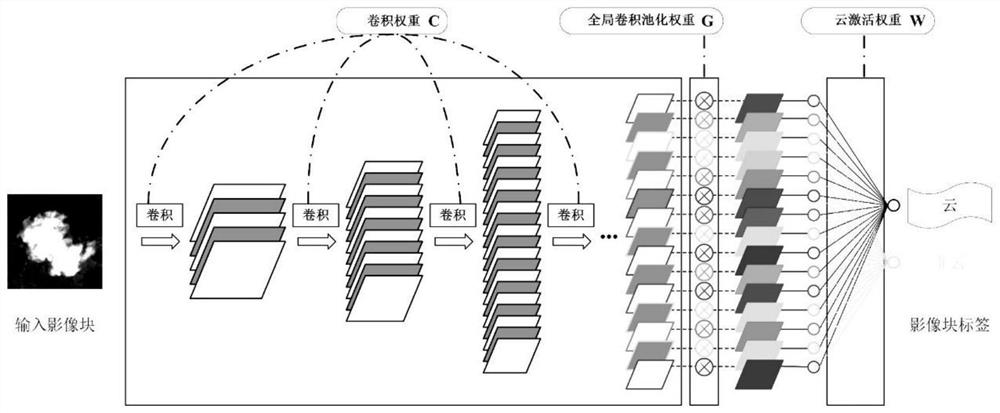
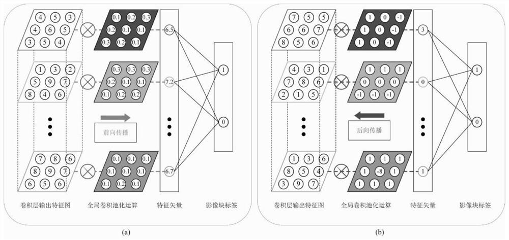
[0053] A remote sensing image scene classification method based on fault-tolerant deep learning provided by the present invention comprises the following steps:

[0054] Step 1: Input the remote sensing image dataset D={(b n ,y n )|n=1, 2,..., N}, where b n Indicates the nth remote sensing image block in the dataset D; y n Indicates the coarse-grained remote sensing image block-level label corresponding to the nth remote sensing image block, y n has two forms, y n =[1,0] represents the nth remote sensing image block b in the data set D n The label is co...


PUM


Abstract

Based on the practical problem that the deep learning-based cloud region detection method needs to cost a lot of labeling, the present invention discloses a pixel-level remote sensing image cloud region detection method based on coarse-grained label-guided deep learning. Image block-level labels, under the constraints of remote sensing image block datasets with coarse-grained image block-level labels, combined with local pooling layer pruning strategies and global convolutional pooling layers, a robust deep network model is trained and cloud generation The activation map is then thresholded to obtain the final cloud mask map. The invention can greatly reduce labeling work, and at the same time realize pixel-level accurate cloud area detection of remote sensing images, and can effectively improve the efficiency and performance of remote sensing image cloud area detection.

Description

technical field [0001] The invention belongs to the technical field of remote sensing and artificial intelligence, and relates to a remote sensing image cloud area detection method based on deep learning, in particular to a pixel-level remote sensing image cloud area detection method guided by coarse-grained labels and deep learning. Background technique [0002] Cloud detection is a key issue in remote sensing image interpretation and application. A large number of cloud cover will affect the availability of remote sensing image data and increase the difficulty of remote sensing image interpretation. Cloud area detection uses various methods in the field of remote sensing and computer vision to detect cloudy areas in remote sensing images. At the level of on-board applications, by not sending images with more clouds, it saves transmission bandwidth and storage space, and reduces resource consumption. Waste; at the level of ground applications, it provides data preparation f...

Claims


Application Information

Patent Timeline
Patent Type & Authority Patents(China)
IPC IPC(8): G06T7/11G06T7/136G06N3/08G06N3/04G06V10/774
CPCG06N3/082G06T7/11G06T7/136G06T2207/10032G06N3/045G06F18/214
Inventor 李彦胜陈蔚张永军
Owner WUHAN UNIV
Why Eureka
Try Eureka