
Automatic route selection and exposure device for aerial survey camera

A technology of aerial survey camera and exposure device, which is applied in the directions of surveying device, photographic device, surveying and mapping and navigation, etc.

Active Publication Date: 2021-01-22
BEIJING RES INST OF SPATIAL MECHANICAL & ELECTRICAL TECH
View PDF4 Cites 0 Cited by
  • Summary
  • Abstract
  • Description
  • Claims
  • Application Information

AI Technical Summary

Problems solved by technology

At the same time, it has the function of automatic inspection of the quality of aerial photographs on the aircraft, which can timely supplement aerial photographs with problems such as missing photographs, poor geometry or radiation quality, effectively improving flight efficiency and reducing flight sorties

Method used


Image

  • Automatic route selection and exposure device for aerial survey camera
  • Automatic route selection and exposure device for aerial survey camera
  • Automatic route selection and exposure device for aerial survey camera

Examples


Embodiment Construction

[0056] In order to make the object, technical solution and advantages of the present invention clearer, the embodiments disclosed in the present invention will be further described in detail below in conjunction with the accompanying drawings.

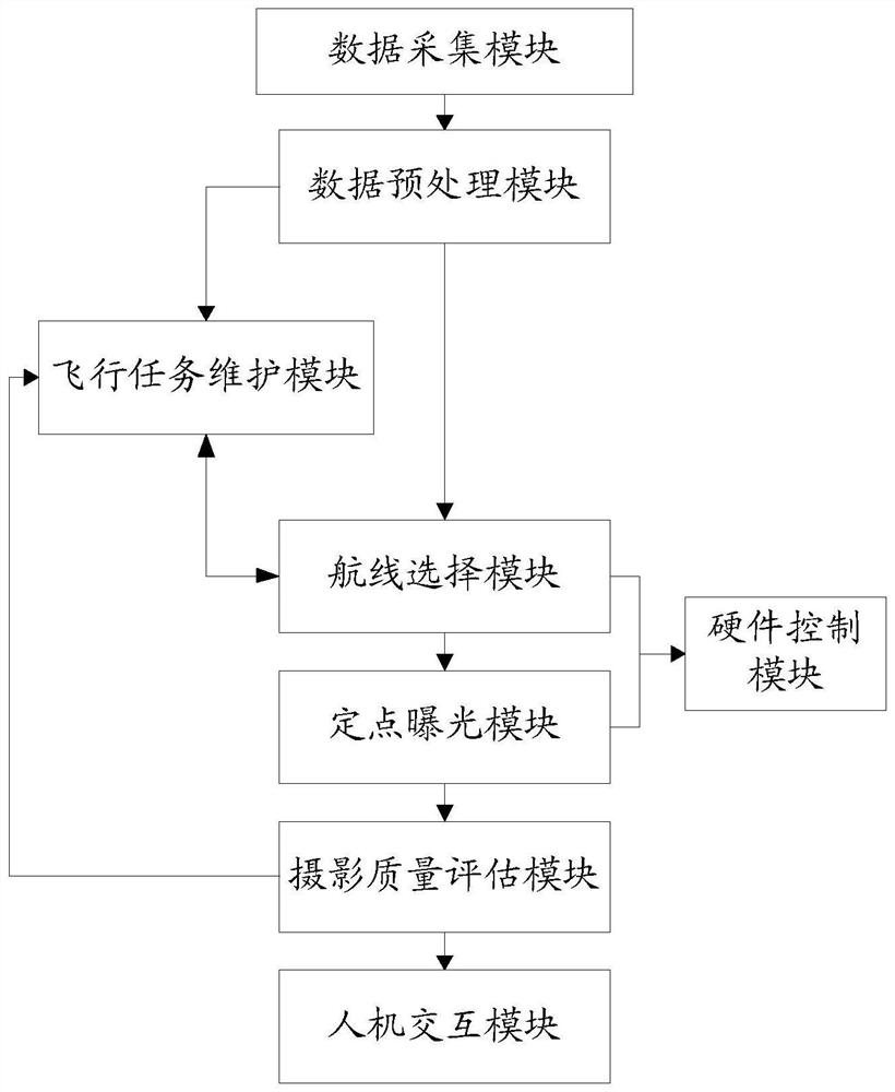
[0057] like figure 1 , in this embodiment, the automatic route selection and exposure device for the aerial survey camera includes:

[0058] The data collection module is used to obtain real-time navigation data and route planning data.

[0059] In this embodiment, the real-time navigation data includes but not limited to: real-time altitude, real-time position, and real-time heading angle of the aircraft. The route planning data includes, but is not limited to: several preset flight routes and several preset intended exposure positions located on each preset flight route.

[0060] Taking the i-th preset flight route as an example, the preset flight route specifically refers to: along the set course Angle AB , According to the set a...


PUM


Abstract

The invention discloses an automatic route selection and exposure device for an aerial survey camera. The device comprises a data collection module which is used for obtaining real-time navigation data and route planning data, a data preprocessing module which is used for performing Gaussian projection preprocessing on the real-time navigation data and the route planning data, a flight mission maintenance module which is used for constructing a flight mission matrix according to the route planning data subjected to Gaussian projection preprocessing, a route selection module which is used for carrying out route judgment according to the real-time navigation data subjected to Gaussian projection preprocessing and the flight mission matrix, a fixed-point exposure module which is used for carrying out exposure judgment after Gaussian projection preprocessing, and a hardware control module which is used for sending a corresponding instruction according to the route judgment result and the exposure judgment result. The flight state of the aerial survey camera can be automatically judged, exposure of the camera and opening and closing of the stable platform are automatically controlled, full-automatic operation of flight missions can be achieved, the exposure point location precision is high, and the variable baseline aerial photography requirement can be met.

Description

technical field [0001] The invention belongs to the technical field of aerial photogrammetry and remote sensing, in particular to an automatic route selection and exposure device for an aerial survey camera. Background technique [0002] Aerial photogrammetry has the advantages of strong autonomy, high precision, flexibility and convenience, etc. It is an effective means to quickly obtain high-precision terrain data. With the rapid progress of technology, advanced aerial photogrammetry systems are generally equipped with stable platforms, which further improves aerial photography The geometric quality of the photo. [0003] Traditional aerial survey cameras use timing or manual exposure methods. These exposure methods will cause differences in exposure intervals, unstable overlapping rates of aerial photos or even missed shots due to factors such as uneven flight speeds and airflow changes, and cannot adapt to variable baseline aviation in hilly areas. photography needs. S...

Claims


Application Information

Patent Timeline
IPC IPC(8): G01C11/00G01C11/02
CPCG01C11/00G01C11/02
Inventor 尚志鸣钟灿李辰刘秀王洪民文高进
Owner BEIJING RES INST OF SPATIAL MECHANICAL & ELECTRICAL TECH
Learn More