Supercharge Your Innovation With Domain-Expert AI Agents!

Method for counting traffic flow of expressway by using unmanned aerial vehicle

A highway and drone technology, applied in the field of traffic flow statistics, can solve problems such as affecting the accuracy of traffic flow statistics

Inactive Publication Date: 2021-02-05
浙江点辰航空科技有限公司
View PDF13 Cites 3 Cited by
  • Summary
  • Abstract
  • Description
  • Claims
  • Application Information

AI Technical Summary

Problems solved by technology

[0003] With the rapid development of UAVs, UAVs are widely used in road condition detection, but UAVs in the prior art have at least the following problems: When UAVs analyze real-time traffic flow, they need to identify images, In the prior art, it is easy to generate lane lines and vehicles are usually identified as foreground during recognition, which affects the accuracy of traffic flow statistics

Method used


Image

  • Method for counting traffic flow of expressway by using unmanned aerial vehicle
  • Method for counting traffic flow of expressway by using unmanned aerial vehicle

Examples


Embodiment Construction

[0024]The technical solutions of the present invention will be further described below in conjunction with the drawings and specific implementations.

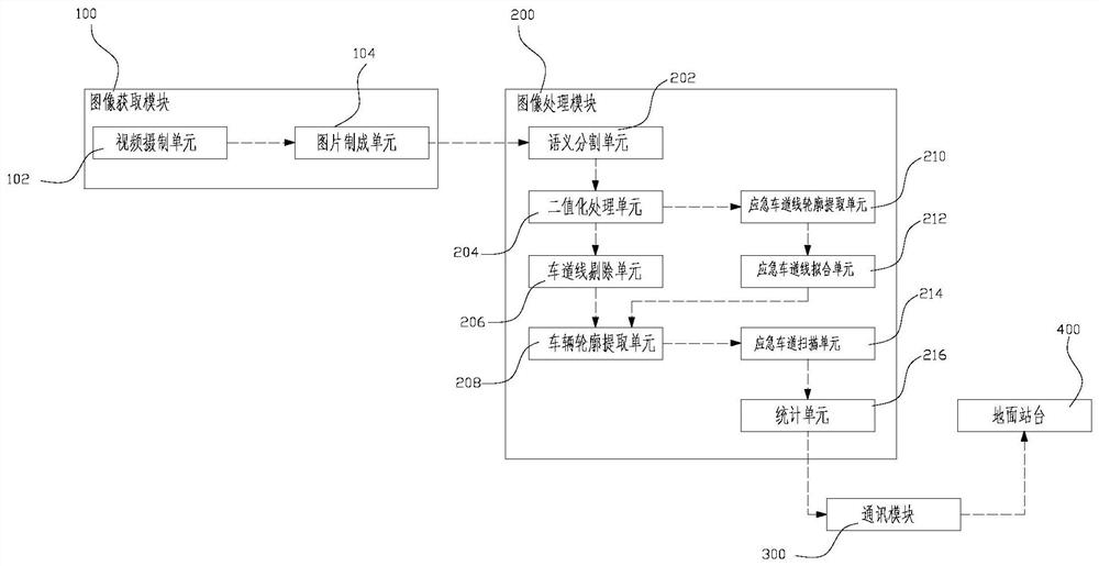
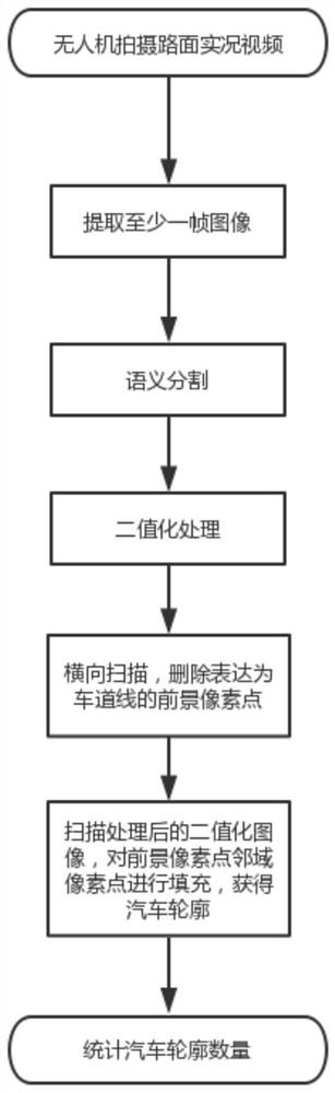
[0025]Such asfigure 1 with2, The present invention includes an image acquisition module 100 for acquiring live images of the road surface and an image processing module 200 for processing the live images. The image processing module 200 includes:

[0026]The semantic segmentation unit 202 performs semantic segmentation on the live image to obtain the lane area and the background area, and remove the background area in the image;

[0027]The binarization processing unit 204 performs binarization processing on the image excluding the background area to obtain a binarized image of the image. In the binarized image, the road surface is the background, and the vehicle and lane lines are the foreground;

[0028]The lane line removal unit 206 scans the binarized image horizontally, defines the horizontally continuous N pixels as foreground pixels as th...


PUM


Abstract

The invention discloses a method for counting traffic flow of an expressway by using an unmanned aerial vehicle, which is characterized by comprising the following steps: S1, enabling the unmanned aerial vehicle to inspect the expressway and shoot a road surface live video; sS, extracting at least one frame of image of the live video; S3, performing semantic segmentation on the image in the step S2; S4, performing binarization on the image to obtain a binarized image; s5, performing transverse scanning on the binarized image, defining N transverse continuous pixel points as foreground pixel points as lane lines, deleting the foreground pixel points defined as the lane lines, and forming an outline of the vehicle by the residual foreground pixel points, with N being a lane width value; andS6, counting the number of the vehicle contours in the step S5. According to the invention, interference factors of lane lines can be provided during counting of traffic flow, so that the accuracy ofcounting results is higher.

Description

Technical field[0001]The invention relates to a method for carrying out traffic flow statistics on expressways by using drones.Background technique[0002]In recent years, as the number of vehicles has continued to rise, road congestion has often occurred, especially on expressways. If it coincides with a holiday, the congestion will be more serious. Therefore, the traffic flow is tracked in real time and the driver is reminded to choose a feasible solution based on the traffic flow of each road. Traveling is one of the most feasible solutions to road congestion.[0003]With the rapid development of UAVs, UAVs are widely used for road condition detection. However, UAVs in the prior art have at least the following problems: UAVs need to recognize images when analyzing real-time traffic flow. In the prior art, lane lines and vehicles are usually recognized as prospects during identification, which affects the accuracy of traffic flow statistics.Summary of the invention[0004]The purpose of...

Claims


Application Information

Patent Timeline
Patent Type & Authority Applications(China)
IPC IPC(8): G06K9/00G06K9/34G06K9/46G08G1/065
CPCG08G1/065G06V20/13G06V10/267G06V10/44G06V2201/08
Inventor 金国强
Owner 浙江点辰航空科技有限公司
Features
  • R&D
  • Intellectual Property
  • Life Sciences
  • Materials
  • Tech Scout
  • Unparalleled Data Quality
  • Higher Quality Content
  • 60% Fewer Hallucinations
Learn More