A UAV-based engineering surveying and mapping device

A surveying and mapping device, unmanned aerial vehicle technology, applied to unmanned aerial vehicles, motor vehicles, aircraft parts, etc., can solve problems such as poor stability, inability to stabilize the surveying and mapping instrument, and inability to control the movement of the surveying and mapping instrument, and achieve the effect of detailed data

Active Publication Date: 2022-06-24
邵明政
View PDF8 Cites 1 Cited by
  • Summary
  • Abstract
  • Description
  • Claims
  • Application Information

AI Technical Summary

Problems solved by technology

[0005] In order to solve the above-mentioned technical problems, the present invention provides an engineering surveying and mapping device based on unmanned aerial vehicles to solve the problem that the existing surveying and mapping devices based on unmanned aerial vehicles have poor stability and cannot be used during flight. The surveying and mapping instrument is more stable, and it cannot buffer the impact force when it lands, and when the existing drone-based surveying and mapping device is in use, it cannot control the movement of the surveying and mapping instrument when it lands, and it is impossible to avoid the contact between the surveying and mapping instrument and the ground. Unable to protect surveying and mapping instruments

Method used


Image

  • A UAV-based engineering surveying and mapping device
  • A UAV-based engineering surveying and mapping device
  • A UAV-based engineering surveying and mapping device

Examples


Embodiment

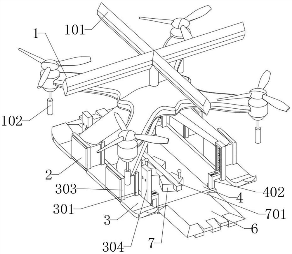
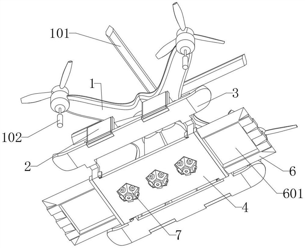
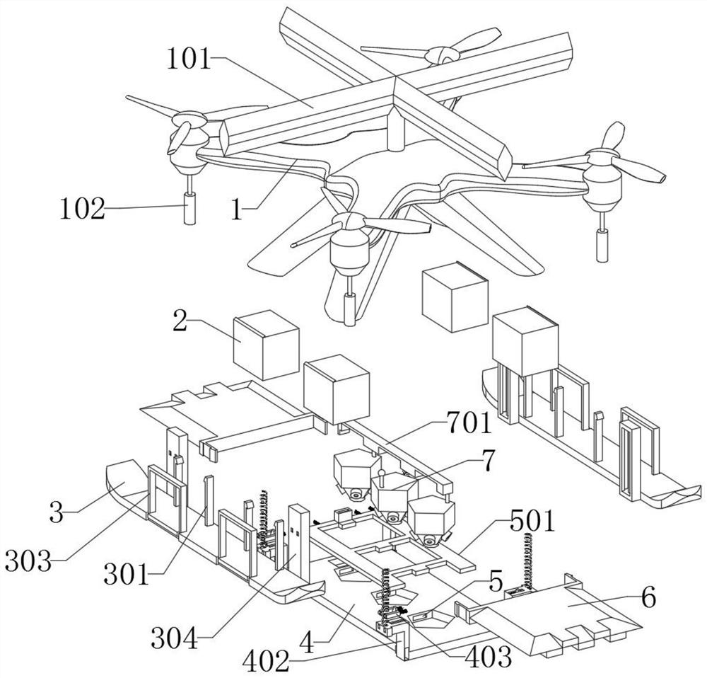
[0034] as attached figure 1 to attach Figure 8 Shown:

[0035] The present invention provides an engineering surveying and mapping device based on an unmanned aerial vehicle, comprising a main body 1, a buffer member 2, a contact plate 3, a receiving member 4, an inner groove 5, a force plate 6 and a surveying instrument 7; the main body 1 is an unmanned aerial vehicle The main body, and the bottom of the main body 1 is provided with four supporting feet; the top of the buffer member 2 is fixedly connected with the bottom of the supporting feet of the main body 1; the inner groove 5 is arranged inside the receiving member 4, and the pentagonal groove of the inner groove 5 is uniform Set inside the receiving part 4; the force plate 6 is installed on both sides of the receiving part 4, and the L-shaped plate of the force plate 6 is inserted into the rectangular groove at the bottom of the force head 402; the surveying instrument 7 is inserted in the pentagon The inside of the...


PUM


Abstract

The invention provides an engineering surveying and mapping device based on a drone, which relates to surveying and mapping device technology and the field of engineering, to solve the problem that the existing surveying and mapping device based on a drone cannot control the movement of the surveying and mapping instrument during engineering surveying and mapping, and cannot avoid surveying and mapping. The instrument is in contact with the ground and cannot protect the surveying and mapping instrument, including the main body; the main body is the drone body, and the bottom of the main body is provided with four supporting feet; the top of the buffer is fixed to the bottom of the supporting feet of the main body connect. The surveying instrument needs sufficient field of view during surveying and mapping, so the bottom of the surveying instrument needs to be placed under the contact plate. When the device needs to land, the main body can be controlled to land quickly, so that the force plate can drive the receiving part to move upwards, and then Compress the spring, and at the same time make the block receive the power of the spring and move outward, so that the outer end of the block can be inserted into the rectangular groove of the guide, so that the receiving part can drive the surveying instrument to limit and fix it, so that the surveying instrument will not touch Damaged ground.

Description

technical field [0001] The invention belongs to the technical field of surveying and mapping devices, and more specifically relates to engineering surveying and mapping devices based on unmanned aerial vehicles. Background technique [0002] Before developing a piece of land or carrying out large-scale engineering construction, it is usually necessary to use mapping drones to measure and draw topographic maps and provide other information before making decisions, planning and design, so surveying and mapping is very important. [0003] For example, the application number: CN201911158254.5 relates to a UAV-based engineering surveying and mapping device, including a UAV and a protection mechanism. An inclined surveying and mapping camera is installed, and a support plate is installed on the top surface of the inclined surveying and mapping camera, and shock absorbing frame mechanisms are installed on both sides of the top surface of the supporting plate, and the shock absorbin...

Claims


Application Information

Patent Timeline
Patent Type & Authority Patents(China)
IPC IPC(8): B64C25/32B64C25/62B64D47/00
CPCB64C25/32B64C25/62B64D47/00B64U30/20B64U2101/00B64U10/10
Inventor 邵明政
Owner 邵明政
Why Eureka
Try Eureka