A Terrain Shading Correction Method for Visible Light Waveband of Remote Sensing Image
A technology of remote sensing image and correction method, which is applied in image detector method and image signal processing, material analysis by optical means, and re-radiation of electromagnetic waves, etc. and other problems to achieve the effect of making up for the failure of falling shadows
- Summary
- Abstract
- Description
- Claims
- Application Information
AI Technical Summary
Problems solved by technology
Method used
Image
Examples
Embodiment Construction
[0060] The present invention will be further described below in conjunction with the accompanying drawings and embodiments.
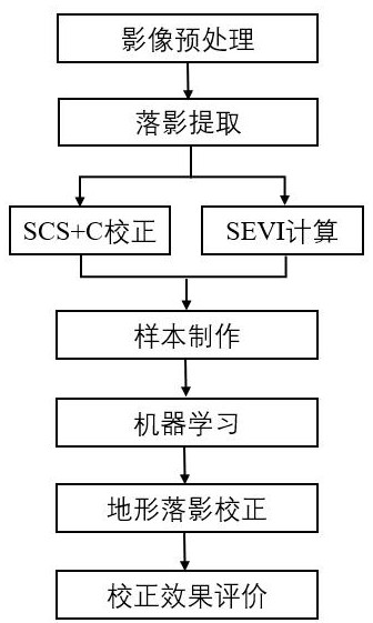
[0061] Please refer to figure 1 , the present invention provides a remote sensing image visible light band terrain fall shadow correction method, comprising the following steps:
[0062] Step S1: Acquire data and preprocess, required data include: satellite remote sensing data, DEM data. Carry out radiometric calibration and atmospheric correction on the satellite remote sensing data, and use the mask file of the study area to clip the atmospheric-corrected surface reflectance data to obtain the surface reflectance data of the study area, and perform projection transformation, resampling and clipping on the DEM data to obtain The DEM data of the research area will finally be standardized into the same data format;
[0063] Step S2: Falling shadow extraction, first extract the overall shadow, then extract the umbra, and finally make a difference between ...
PUM
 Abstract
Description
Claims
Application Information
 - R&D
- Intellectual Property
- Life Sciences
- Materials
- Tech Scout
- Unparalleled Data Quality
- Higher Quality Content
- 60% Fewer Hallucinations
Browse by: Latest US Patents, China's latest patents, Technical Efficacy Thesaurus, Application Domain, Technology Topic, Popular Technical Reports.
© 2025 PatSnap. All rights reserved.Legal|Privacy policy|Modern Slavery Act Transparency Statement|Sitemap|About US| Contact US: help@patsnap.com


