Road engineering surveying and mapping intelligent management system based on geographic feature processing technology

A technology of road engineering and geographical features, applied in the field of engineering surveying and mapping management, can solve the problems of wasting human resources and time costs, reducing the efficiency of road engineering surveying and mapping, and increasing the cycle of road engineering surveying and mapping, saving human resources and time costs. , Improve the efficiency of surveying and mapping, and reduce the effect of surveying and mapping cycles

Active Publication Date: 2021-06-25
广东广量测绘信息技术有限公司
View PDF6 Cites 2 Cited by
  • Summary
  • Abstract
  • Description
  • Claims
  • Application Information

AI Technical Summary

Problems solved by technology

[0002] In road engineering construction, engineering surveying and mapping work is the basis of the entire engineering project. With the continuous development of society and the continuous advancement of science and technology, traditional surveying, surveying and mapping technology can no longer meet the needs of current road engineering construction. Traditional road engineering surveying, surveying and mapping The method mainly adopts field survey, that is, surveyors use traditional operation tools to carry out continuous field survey, mapping and recording, and there is a problem of large workload of surveying and mapping data recording, sorting and digitization, which wastes a lot of human resources and time costs, and increases road engineering costs. The survey and mapping cycle of road engineering reduces the efficiency of road engineering survey, survey and map. At the same time, the traditional road engineering survey, survey and map management system requires a large number of personnel to analyze the difficulty of road engineering construction together with survey data, and cannot realize efficient processing and analysis of road engineering survey, survey and map data. As a result, the construction needs of road engineering projects cannot be met, and the construction management level of road engineering projects is affected. In order to solve the above problems, an intelligent management system for road engineering surveying and mapping based on geographic feature processing technology is now designed

Method used


Image

  • Road engineering surveying and mapping intelligent management system based on geographic feature processing technology

Examples


Embodiment Construction

[0036] The following will clearly and completely describe the technical solutions in the embodiments of the present invention with reference to the accompanying drawings in the embodiments of the present invention. Obviously, the described embodiments are only some, not all, embodiments of the present invention. Based on the embodiments of the present invention, all other embodiments obtained by persons of ordinary skill in the art without creative efforts fall within the protection scope of the present invention.

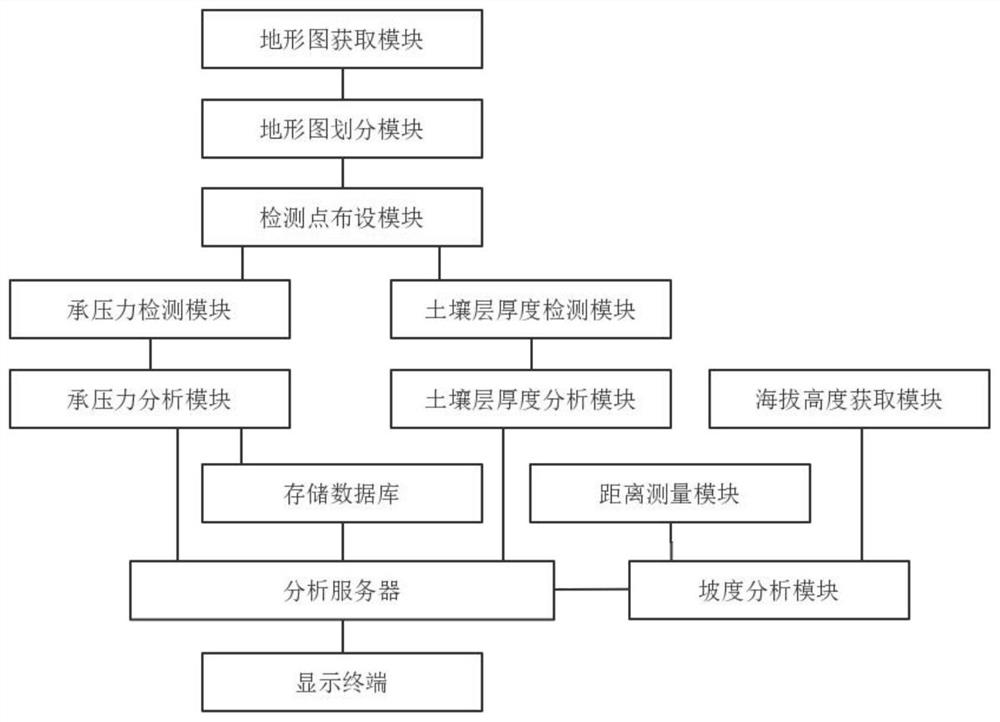
[0037] see figure 1 As shown, an intelligent management system for road engineering surveying and mapping based on geographic feature processing technology, including topographic map acquisition module, topographic map division module, detection point layout module, bearing pressure detection module, bearing pressure analysis module, and soil layer thickness detection module , a soil layer thickness analysis module, an altitude acquisition module, a distance measur...


PUM


Abstract

The invention discloses a road engineering investigation surveying and mapping intelligent management system based on a geographic feature processing technology. The system comprises the steps: dividing a topographic map of a to-be-constructed road engineering region into terrain sub-regions according to different terrain types, and carrying out the arrangement of a plurality of detection points for each terrain sub-region, Detecting the geological bearing pressure at each detection point in each terrain sub-region, comparing to obtain the geological bearing pressure difference value at each detection point in each terrain sub-region, detecting the thickness of each soil layer at each detection point in each terrain sub-region, and calculating the average thickness of each soil layer in each terrain sub-region; The highest altitude, the lowest altitude and the distance between the highest altitude and the lowest altitude of each terrain sub-region are respectively obtained, the gradient of each terrain sub-region is analyzed, and the investigation construction difficulty influence coefficient of the road engineering region to be constructed is comprehensively calculated and displayed, so that the investigation surveying and mapping efficiency of the road engineering is improved, and the construction efficiency is improved. And the construction requirements of road engineering projects are met.

Description

technical field [0001] The invention relates to the management field of engineering survey, surveying and mapping, and relates to an intelligent management system for road engineering surveying, surveying and mapping based on geographic feature processing technology. Background technique [0002] In road engineering construction, engineering surveying and mapping work is the basis of the entire engineering project. With the continuous development of society and the continuous advancement of science and technology, traditional surveying, surveying and mapping technology can no longer meet the needs of current road engineering construction. Traditional road engineering surveying, surveying and mapping The method mainly adopts field survey, that is, surveyors use traditional operation tools to carry out continuous field survey, mapping and recording, and there is a problem of large workload of surveying and mapping data recording, sorting and digitization, which wastes a lot of ...

Claims


Application Information

Patent Timeline
IPC IPC(8): G06Q10/06G06Q50/08G06F16/29G06F16/2458G06F16/245G06F16/248
CPCG06Q10/0639G06Q50/08G06F16/29G06F16/2462G06F16/245G06F16/248
Inventor 万思
Owner 广东广量测绘信息技术有限公司
Why Eureka
Try Eureka