Electric power engineering project intelligent surveying and mapping method based on remote unmanned aerial vehicle and sensor technology

A sensor technology and power engineering technology, applied in the field of intelligent surveying and mapping of power engineering projects, can solve the problems of reducing the surveying and mapping efficiency of wind power engineering projects, wasting human resources and time costs, reducing the processing accuracy of surveying and mapping data, etc., to improve wind power engineering projects. Efficiency of surveying and mapping, saving human resources and time costs, and avoiding the effect of large manual statistical errors

Inactive Publication Date: 2021-06-15
刘燕
View PDF0 Cites 0 Cited by
  • Summary
  • Abstract
  • Description
  • Claims
  • Application Information

AI Technical Summary

Problems solved by technology

At present, the existing surveying and mapping technology can no longer meet the construction needs of current wind power engineering projects. The existing surveying and mapping technology of wind power engineering projects still needs to manually survey the terrain in the field, which not only wastes a lot of human resources and time costs, but also increases wind power. The survey cycle of engineering projects, thereby reducing the survey and mapping efficiency of wind power engineering projects. At the same time, the existing technology requires personnel to summarize a large amount of survey data to comprehensively analyze the highest power generation efficiency and corresponding orientation in the pre-construction area. The existence of manual statistical errors leads to the reliability of the analysis results. The accuracy is not high, which reduces the accuracy of wind power engineering project surveying and mapping data processing, and thus cannot meet the construction needs of wind power engineering projects, which seriously affects the level of wind power engineering project surveying and mapping. In order to solve the above problems, a design based on Smart Survey and Mapping Method for Power Engineering Projects with Remote UAV and Sensor Technology

Method used


Image

  • Electric power engineering project intelligent surveying and mapping method based on remote unmanned aerial vehicle and sensor technology
  • Electric power engineering project intelligent surveying and mapping method based on remote unmanned aerial vehicle and sensor technology

Examples


Embodiment Construction

[0041] The following will clearly and completely describe the technical solutions in the embodiments of the present invention with reference to the accompanying drawings in the embodiments of the present invention. Obviously, the described embodiments are only some of the embodiments of the present invention, not all of them. Based on the embodiments of the present invention, all other embodiments obtained by persons of ordinary skill in the art without creative efforts fall within the protection scope of the present invention.

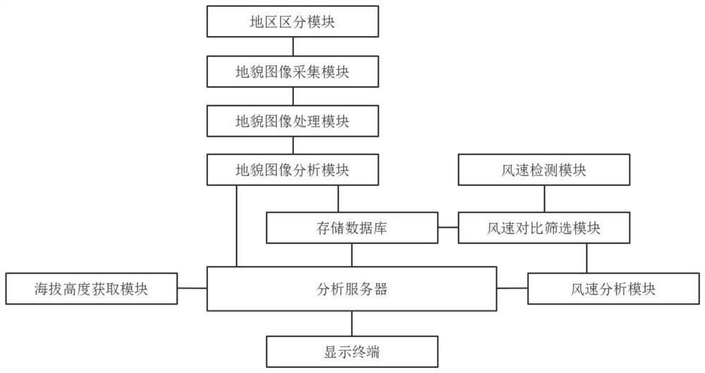
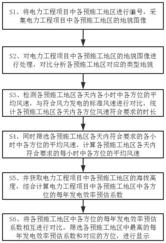
[0042] see figure 1 As shown, the present invention provides an intelligent survey and mapping method for power engineering projects based on remote unmanned aerial vehicles and sensor technology, which needs to be used in the specific implementation process An intelligent survey and mapping system for power engineering projects based on remote drones and sensor technology, the intelligent survey and mapping system for power engineering projects based...


PUM


Abstract

The invention discloses an electric power engineering project intelligent surveying and mapping method based on a remote unmanned aerial vehicle and sensor technology, and the method comprises the steps: collecting landform images of all pre-construction regions in an electric power engineering project, carrying out the comparative analysis of the type landform corresponding to each pre-construction region, detecting the average wind speed of each pre-construction region in each hour in each day, comparing and counting the duration that the wind speed of each direction in each day of each pre-construction region meets the requirement, screening the average wind speed of each direction in each hour meeting the requirement in each day of each pre-construction region, and calculating the average wind speed of each direction in each hour meeting the requirement in each day of each pre-construction region; meanwhile, obtaining the altitude of each pre-construction region in the electric power engineering project, and calculating the annual power generation efficiency estimation coefficient of each orientation in each pre-construction region, comparing and screening the highest annual power generation efficiency estimation coefficient and the corresponding orientation in each pre-construction region, and displaying the highest annual power generation efficiency estimation coefficient and the corresponding orientation, so that the surveying and mapping level of the wind power engineering project is improved.

Description

technical field [0001] The invention relates to the technical field of engineering surveying and mapping, and relates to an intelligent surveying and mapping method for electric power engineering projects based on remote drone and sensor technology. Background technique [0002] The construction of wind power projects meets the current energy production and development strategies in my country, can get the support of national policies and implementation of programs, and can maintain the ecological environment. At present, the existing surveying and mapping technology can no longer meet the construction needs of current wind power engineering projects. The existing surveying and mapping technology of wind power engineering projects still needs to manually survey the terrain in the field, which not only wastes a lot of human resources and time costs, but also increases wind power. The survey cycle of engineering projects, thereby reducing the survey and mapping efficiency of w...

Claims


Application Information

Patent Timeline
Patent Type & Authority Applications(China)
IPC IPC(8): G06Q10/04G06Q50/06G06K9/00G06K9/40G01D21/02
CPCG06Q10/04G06Q50/06G01D21/02G06V20/13G06V10/30Y04S10/50Y02E40/70
Inventor 刘燕
Owner 刘燕
Why Eureka
Try Eureka