Check patentability & draft patents in minutes with Patsnap Eureka AI!

Lane-level path planning method for automatic driving lane-level navigation

A technology for path planning and automatic driving, applied in the directions of road network navigator, navigation, mapping and navigation, etc., can solve the problems of low search efficiency, difficult to meet the real-time requirements of vehicle operation, and complex lane connection relationship.

Active Publication Date: 2021-07-23
JILIN UNIV
View PDF8 Cites 10 Cited by
  • Summary
  • Abstract
  • Description
  • Claims
  • Application Information

AI Technical Summary

Problems solved by technology

[0006] For the lane-level path planning method for lane-level navigation, the previous method used lane as a unit to search, and the number of lanes is large in the case of a large road network , the connection relationship between lanes is complex, the search efficiency is low, and it is difficult to meet the real-time requirements of vehicle operation

Method used


Image

  • Lane-level path planning method for automatic driving lane-level navigation
  • Lane-level path planning method for automatic driving lane-level navigation
  • Lane-level path planning method for automatic driving lane-level navigation

Examples


Embodiment Construction

[0060] The following will clearly and completely describe the technical solutions in the embodiments of the present invention with reference to the accompanying drawings in the embodiments of the present invention. Obviously, the described embodiments are only some of the embodiments of the present invention, not all of them. Based on the embodiments of the present invention, all other embodiments obtained by persons of ordinary skill in the art without making creative efforts belong to the protection scope of the present invention.

[0061] The present invention will be further described in detail below in conjunction with the accompanying drawings and embodiments.

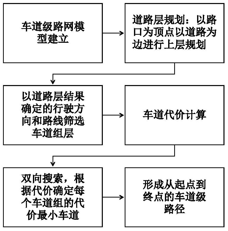
[0062] Step 1. First, establish a lane-level road network model for automatic driving navigation;

[0063] In the present invention, the set of lanes on the same road in the same direction is defined as a lane group, and the model established by the present invention involves the relationship between roads, lane ...


PUM


Abstract

The invention relates to the field of automatic driving navigation and electronic maps, in particular to a lane-level path planning method for automatic driving lane-level navigation. The method includes the steps that 1, a lane-level road network model for automatic driving navigation is established, and the model form is simple, visual and convenient to plan; and 2, road-lane group-lane-based layered two-way lane-level path planning is carried out based on the lane-level road network model established in the step 1. According to the invention, the vehicle can rapidly and accurately plan the optimal lane sequence from the starting point to the terminal point, i.e., the lanes on which the vehicle drives in sequence from the starting point to the terminal point, thereby effectively serving an automatic driving navigation system.

Description

technical field [0001] The invention relates to the fields of automatic driving navigation and electronic maps, in particular to a lane-level path planning method for automatic driving lane-level navigation. Background technique [0002] More and more drivers rely on digital map navigation systems in vehicles or mobile phones to choose the best driving route to save time and improve safety. Currently, most vehicle navigation systems are based on road-level maps with limited information and low accuracy. In recent years, the development of advanced driver assistance systems and autonomous driving technology requires more and more help from digital maps. In the near future, the digital map navigation system will play an increasingly important role in the transportation system. In order to extend existing navigation systems to more applications, two fundamental problems must be solved: lane-level map models and lane-level path planning. Many smart driving functions based on ...

Claims


Application Information

Patent Timeline
IPC IPC(8): G01C21/34
CPCG01C21/3415G01C21/3446
Inventor 何科丁海涛张建伟李嘉嘉郭孔辉潘新博洪雨希赖宣淇
Owner JILIN UNIV
Features
  • R&D
  • Intellectual Property
  • Life Sciences
  • Materials
  • Tech Scout
  • Unparalleled Data Quality
  • Higher Quality Content
  • 60% Fewer Hallucinations
Learn More