Risk-avoiding satellite navigation system for flood prevention and use method thereof

A satellite navigation system, No. 1 technology, applied in the field of satellite navigation, can solve problems affecting the work efficiency of flood control personnel, and achieve a stable and reliable mechanical structure

Inactive Publication Date: 2021-07-30
苏州凯跃达阀门有限公司
View PDF0 Cites 0 Cited by
  • Summary
  • Abstract
  • Description
  • Claims
  • Application Information

AI Technical Summary

Problems solved by technology

[0003] In emergency flood control operations, the staff usually only wear a simple safety suit to work, but thin safety suits are not enough to fight against raging floods, but the protective safety suits currently on the market usually affect the work of flood control personnel efficiency

Method used


Image

  • Risk-avoiding satellite navigation system for flood prevention and use method thereof
  • Risk-avoiding satellite navigation system for flood prevention and use method thereof
  • Risk-avoiding satellite navigation system for flood prevention and use method thereof

Examples


Embodiment Construction

[0024] In the description of the present invention, it should be noted that the orientations or positional relationships indicated by the terms "upper", "lower", "inner", "outer", "top / bottom" etc. are based on the orientations shown in the drawings Or positional relationship is only for the convenience of describing the present invention and simplifying the description, but does not indicate or imply that the device or element referred to must have a specific orientation, be constructed and operated in a specific orientation, and therefore should not be construed as limiting the present invention. In addition, the terms "first" and "second" are used for descriptive purposes only, and should not be understood as indicating or implying relative importance.

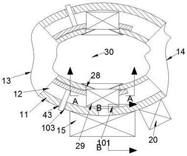
[0025] refer to Figure 1-6, according to an embodiment of the present invention, a satellite navigation system for avoiding floods, including two vertically symmetrical fixed mounts 11, the upper and lower sides of the fix...


PUM


Abstract

The invention discloses a risk-avoiding satellite navigation system for flood prevention and a use method thereof.The risk-avoiding satellite navigation system comprises two fixing frames which are symmetrically arranged up and down, the upper side face and the lower side face of each fixing frame are in an arc shape, and the outward arc surface region of each fixing frame is large; the left side faces of the two fixing frames are connected through a first air bag, the right side faces of the two fixing frames are connected through a second air bag, and the first air bag, the second air bag and the annular faces of the fixing frames jointly form a wearing cavity. The risk-avoiding satellite navigation system for flood prevention is only a fixing frame fixed to the chest and the back when being not triggered, and the flood prevention operation of workers cannot be influenced; the state of flood prevention personnel can be recognized through a mechanical structure, the air bag can be automatically inflated when the flood prevention personnel encounter danger, and the mechanical structure is stable and reliable; a navigation block is arranged in the system and can be automatically triggered in a specific state, and the position can be fed back in real time.

Description

technical field [0001] The invention relates to the technical field of satellite navigation, in particular to a flood control and avoidance satellite navigation system and a method for using the same. Background technique [0002] In order to prevent and mitigate flood disasters, relevant work is carried out in flood forecasting, flood control dispatching, and flood control engineering applications. The main contents of flood control include: long-term. mid term. Short-term weather forecast, flood water forecast, dispatch and use of flood control projects such as dikes, reservoirs, sluices, flood storage and detention areas, emergency rescue and disaster relief after dangerous disasters, emergency measures under extraordinary circumstances, etc. [0003] In emergency flood control operations, the staff usually only wear a simple safety suit to work, but thin safety suits are not enough to fight against raging floods, but the protective safety suits currently on the market ...

Claims


Application Information

Patent Timeline
Patent Type & Authority Applications(China)
IPC IPC(8): B63C9/00B63C9/125G01S19/17
CPCB63C9/00B63C9/1255B63C2009/0017G01S19/17
Inventor 郑希慧
Owner 苏州凯跃达阀门有限公司
Why Eureka
Try Eureka