Air route shooting method

A shooting method and route technology, applied in the field of route shooting, can solve the problems of unfavorable collection of high-rise building data by the original unit route, poor shooting and collection effects, etc., and achieve the effect of improving shooting efficiency and collection effect, and improving data collection effect

Active Publication Date: 2021-08-03
CHENGDU RAINPOO TECH CO LTD
View PDF14 Cites 2 Cited by
  • Summary
  • Abstract
  • Description
  • Claims
  • Application Information

AI Technical Summary

Problems solved by technology

[0004] In order to solve the above problems, the present invention provides a method for taking photos of air routes. By adopting this scheme, the situation that the original unit air routes are not conducive to the collection of high-rise building data is solved, and the data collection effect of high-rise buildings in cities is improved. Even if there are high-rise buildings in the survey area Buildings can also collect high-quality data; and according to the various heights and densities of buildings or building groups, a variety of interval shooting methods are provided, which can solve the poor shooting and collection effects of buildings or building groups in various complex terrains problem, greatly improving the shooting efficiency and collection effect

Method used


Image

  • Air route shooting method
  • Air route shooting method
  • Air route shooting method

Examples


Embodiment 1

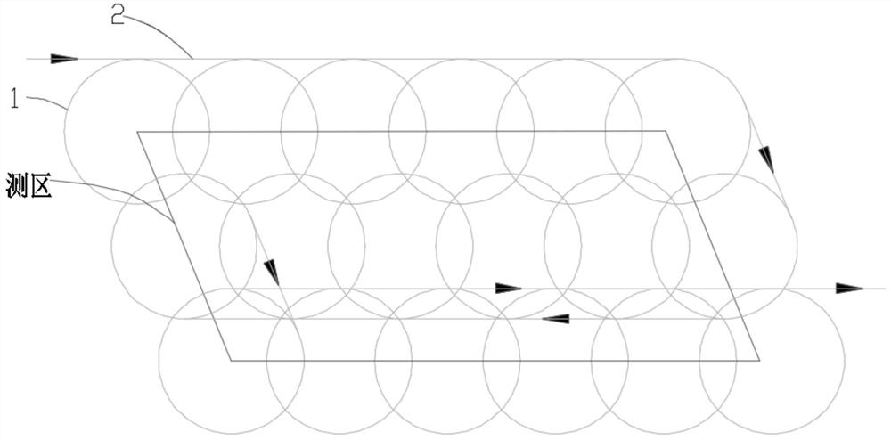
[0039] Embodiment one: if Figure 1 to Figure 7 As shown, the specific steps of a route planning method in this embodiment are:

[0040] 1. Divide the survey area (including the extended area of ​​the survey area) into several units of the same size, and the aircraft flies in each unit according to the route of the predetermined shape, and then connects the routes of each unit to form a complete flight route 6. These routes in each unit are called unit routes, and the routes connecting each unit route are called connecting routes. The unit routes are encircling, and their shapes can be regular polygons such as squares, regular hexagons, and regular octagons. is round. The route generated in this way is called the original route, the unit route in this route is called the original unit route 1, and the connecting route in this route is called the original connecting route 2.

[0041] 2. The following is the calculation method for the flight height, radius and number of photo...

Embodiment 2

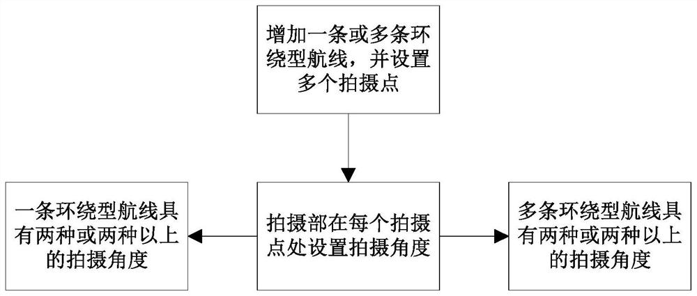
[0067] Embodiment two: if Figure 8 As shown, this embodiment is further optimized on the basis of Embodiment 1. Aiming at changing the shooting angle of the camera of the encircling route 11 according to the height or density of buildings or building groups, this embodiment provides a route shooting method , including the following steps:

[0068] Set up one or more encircling routes 11 for the survey area;

[0069] The shooting department shoots at a certain pitch angle on multiple points of each circumnavigation route 11;

[0070] The photographing unit has at least two pitch angles, and different pitch angles are arranged at intervals.

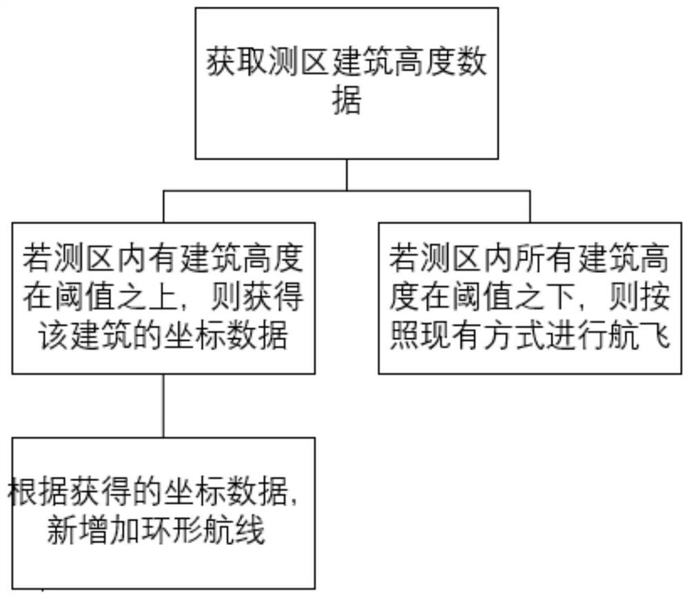
[0071] In this embodiment, because the original unit route 1 is not good for shooting and collecting effects on high-rise buildings 31 or building groups, so at the high-rise buildings 31 or building groups, it is necessary to add a new circular route, that is, a circle-type route 11, but for For buildings with different heights or dens...


PUM


Abstract

The invention provides an air route shooting method, and relates to the technical field of annular air route data acquisition. The method comprises the following steps of: setting one or more surrounding air routes for a measurement area; and enabling a shooting part to shoot on a plurality of points of each surrounding type air route according to a certain pitch angle, wherein the shooting part has at least two pitching angles, and the different pitching angles are arranged at intervals. By the adoption of the air route shooting method, the problem that an original unit air route is not beneficial to collection of high-rise building data is solved, the data collection effect of urban high-rise buildings is improved, and high-quality data can be collected even if high-rise buildings exist in a measurement area; and according to various heights and densities of the buildings or the building groups, various spaced arrangement shooting methods are provided, so that the problem of poor shooting and acquisition effects of the buildings or the building groups in various complex terrains can be solved, and the shooting efficiency and the acquisition effect are greatly improved.

Description

technical field [0001] The invention relates to the technical field of ring route data collection, in particular to a route photographing method. Background technique [0002] In the prior art, data collection using a circumnavigation route is an emerging data collection method in the field of oblique photography. Compared with the previous five-camera data collection method, this method requires fewer cameras and less data volume; but This method currently only works well in suburban or rural areas, but because of the poor effect of this method on data collection of high-rise buildings, the effect in urban high-rise areas is poor. [0003] Therefore, how to use the data collection method of the encircling route to improve the data collection effect in urban high-rise buildings is a problem that needs to be solved urgently. Contents of the invention [0004] In order to solve the above problems, the present invention provides a method for taking photos of air routes. By a...

Claims


Application Information

Patent Timeline
Patent Type & Authority Applications(China)
IPC IPC(8): H04N5/232G05D1/10
CPCG05D1/101H04N23/60H04N23/695Y02A90/10
Inventor 李成田圣地何世雄李小龙于静
Owner CHENGDU RAINPOO TECH CO LTD
Why Eureka
Try Eureka