A route planning method, device, and flight equipment for airborne laser radar

An airborne laser radar and flight equipment technology, applied in the field of communication, can solve the problems of the return route crashing into mountains, user loss, and inability to imitate the ground, and achieve the effect of ensuring data quality and improving safety.

Active Publication Date: 2021-11-09
成都纵横大鹏无人机科技有限公司 +1
View PDF0 Cites 0 Cited by
  • Summary
  • Abstract
  • Description
  • Claims
  • Application Information

AI Technical Summary

Problems solved by technology

When the slope angle of the ground is greater than the maximum climb angle of the aircraft, it will cause the ground imitation flight to be impossible
That is to say, the relative height of the aircraft to the ground in certain flight segments will be less than a given height, and the relative flight height of the UAV to the ground cannot be kept fixed, which will lead to a decrease in the data quality of the lidar, such as uneven point cloud density Wait
In some special cases, if the distance between the aircraft and the ground is too close, some protection mechanisms of the aircraft may be triggered, such as return flight, etc., but due to terrain restrictions, the return route of the aircraft may trigger the risk of collision with mountains, which will cause serious harm to users. huge loss

Method used


Image

  • A route planning method, device, and flight equipment for airborne laser radar
  • A route planning method, device, and flight equipment for airborne laser radar
  • A route planning method, device, and flight equipment for airborne laser radar

Examples


Embodiment Construction

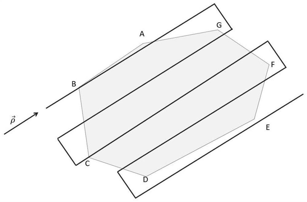
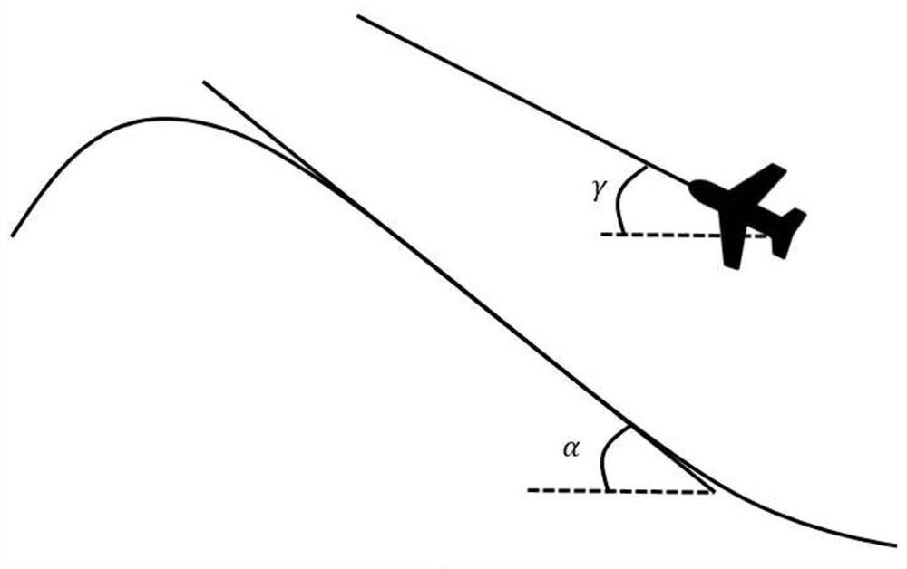
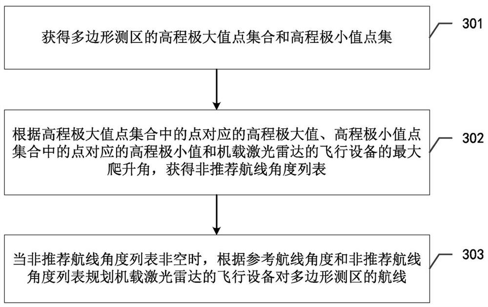
[0109] As described above, the problem of the small maximum climb angle of the flight equipment is often ignored when the flight equipment of the airborne lidar is currently planning the route. In some areas where the ground elevation changes greatly, the flight equipment cannot normally imitate the ground. On the one hand, it affects the quality of data, on the other hand, the operation safety is low. Based on this problem, the inventor, after research, provides a route planning method, device and flight equipment for airborne lidar, according to the list of reference route angles and non-recommended route angles, the flight equipment of airborne lidar plans the polygon survey area. The route can make the planned route avoid non-recommended route angles, improve the safety of the flight equipment of the airborne lidar, and ensure the data quality of the lidar.

[0110] In order to enable those skilled in the art to better understand the solution of the present application, t...


PUM


Abstract

The present application discloses a flight route planning method, device and airborne laser radar flight equipment. Obtain the elevation maximum point set and elevation minimum point set of the polygon survey area. According to the elevation maximum value corresponding to the point in the elevation maximum point set, the elevation minimum value corresponding to the point in the elevation minimum point set, and the maximum climb angle of the flight equipment of the airborne lidar, the non-recommended route angle is obtained list. When the list is not empty, plan the route of the flight equipment of the airborne lidar to the polygon survey area according to the list of reference route angles and non-recommended route angles. The reference route angle is the route angle corresponding to the route planned for the polygon survey area according to the preset constraints , the preset constraint condition is the shortest total voyage. According to the list of reference route angles and non-recommended route angles, the route of the flight equipment of the airborne lidar to the polygon survey area can be planned, which can avoid the non-recommended route angles, improve the safety of the flight equipment, and ensure the data quality of the lidar.

Description

technical field [0001] The present application relates to the field of communication technology, in particular to a route planning method, device and flight equipment for airborne laser radar. Background technique [0002] In recent years, with the rapid development of lidar technology and UAV technology, UAV-borne lidar systems have become more and more widely used in various fields. Such as surveying and mapping, agricultural plant protection, forestry survey and power inspection, etc. Due to the fast flight speed of fixed-wing drones and long time in the air, the operation efficiency of fixed-wing drone-borne lidar is very high, and it is highly sought after by users in the surveying and mapping industry. [0003] Lidar is especially suitable for forestry surveys and topographic mapping due to its strong laser point penetration and the ability to obtain multiple echo data. Traditional surveying and mapping applications usually select a polygonal survey area and then for...

Claims


Application Information

Patent Timeline
Patent Type & Authority Patents(China)
IPC IPC(8): G05D1/10
CPCG05D1/101
Inventor 黎治坤刘金沧黄小川雷雳马云峰刘述超杨建杨珂
Owner 成都纵横大鹏无人机科技有限公司
Why Eureka
Try Eureka