Enterprise geographic information query and display system

A geographic information and display system technology, applied in the field of enterprise geographic information query and display systems, can solve problems such as screen freezing, affecting user experience, limited memory, etc., achieve smooth operation, realize multi-real-time search, and meet multi-user use Effect

Inactive Publication Date: 2017-02-22
成都数联铭品科技有限公司
View PDF7 Cites 10 Cited by
  • Summary
  • Abstract
  • Description
  • Claims
  • Application Information

AI Technical Summary

Problems solved by technology

Using smartphones as the carrier to realize vertical search and corporate geographic information analysis for enterprises will bring great convenience to users. However, existing smartphones have limited memory, load too many applications, and the screen freezes when using them. Causing occurs frequently, which seriously affects the user experience

Method used


Image

  • Enterprise geographic information query and display system
  • Enterprise geographic information query and display system
  • Enterprise geographic information query and display system

Examples


Embodiment 1

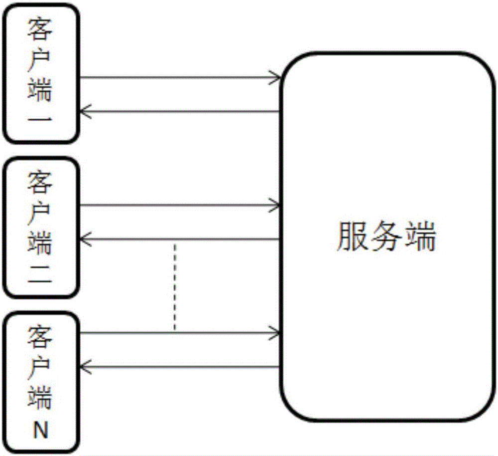
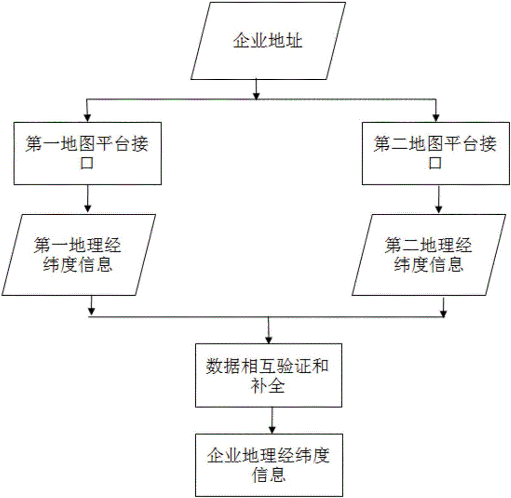
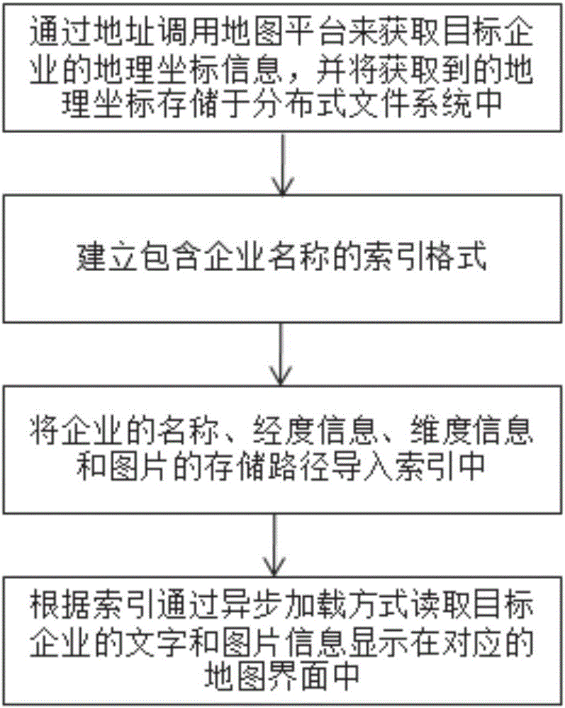
[0049] The working principle and the function realization process of the system of the present invention are described by embodiment 1: as image 3 As shown, on the basis of the name and address data of each enterprise; the server invokes the public map platform interface to obtain the geographic latitude and longitude data of the corresponding enterprise according to the address of each enterprise. In order to ensure the accuracy of the obtained latitude and longitude data, the service The terminal calls at least two map platform interfaces to obtain the corresponding latitude and longitude data. An enterprise is taken as an example to illustrate the invention system, data acquisition, storage and display process; for example: Chengdu ABCD Technology Co., Ltd., the address is: Tianfu Avenue, Chengdu In the middle section xx, the server calls the interface of the first map platform according to the address information to obtain the geographic longitude and latitude information ...


PUM


Abstract

The invention relates to the internet information processing field, and especially relates to an enterprise geographic information query and display system. The system comprises a client and a server; the client is in communication connection with the server; and the client adopts a way of asynchronous display to realize the query and display of enterprise geographic information. The system of the invention takes an enterprise as a specialized analysis object, establishes the function of data storage, reading and displaying for the enterprise geographic information query and display, and fills a technical vacancy that services are not specifically provided for providing map information for the enterprise; and the client adopts a way of asynchronous loading to realize the display of the enterprise geographic information, so that the fluency is ensured and user experience is improve; in addition, at least two map platform interfaces are called at the server to acquire geographic latitude and longitude information, so as to realize mutual authentication and completion of data, and guarantee the data quality; and besides, ElasticSearch is also used as the basis of data storage and index, which can realize real-time search and meet the needs of multi-users use.

Description

technical field [0001] The invention relates to the field of Internet information processing, in particular to an enterprise geographic information query and display system. Background technique [0002] With the social progress represented by the development of information technology, the accumulation of data and information has grown exponentially. The development of network technology has promoted the dissemination and accumulation of information. Network information data covers society, economy, politics, industries, enterprises, organizations, individuals In all aspects of activities, the large amount of data and low value density are the problems that plague the mining and utilization of such massive data information. In the massive data, how to accurately obtain the information that people care about has become an urgent problem to be solved. In the face of huge market demand, the Internet Search and big data analysis have become popular in today's Internet applicatio...

Claims


Application Information

Patent Timeline
Patent Type & Authority Applications(China)
IPC IPC(8): G06F17/30H04L29/06
CPCG06F16/24G06F16/2453G06F16/29H04L67/01
Inventor 谢懿盛云范从俊
Owner 成都数联铭品科技有限公司
Why Eureka
Try Eureka