System and method for determining airfield runway of unmanned plane

A technology of airfields and runways, which is applied in the system field of determining UAV runways, can solve the problems of low automation, high labor intensity, and low work efficiency, and achieve the effect of ensuring data quality, reducing labor intensity, and improving work efficiency

Active Publication Date: 2012-08-15
CAIHONG DRONE TECH CO LTD
View PDF2 Cites 9 Cited by
  • Summary
  • Abstract
  • Description
  • Claims
  • Application Information

AI Technical Summary

Problems solved by technology

[0002] Currently known UAV airport runway position and heading information calibration methods use a real system (UAV) to measure (the UAV is manually pushed on the existing runway to measure the UAV's runway) or use various general-purpose Surveying and mapping methods have a low degree of automation, high labor intensity, and low work efficiency, and the calibration effect cannot be quickly given a quantitative judgment

Method used


Image

  • System and method for determining airfield runway of unmanned plane
  • System and method for determining airfield runway of unmanned plane
  • System and method for determining airfield runway of unmanned plane

Examples


Embodiment Construction

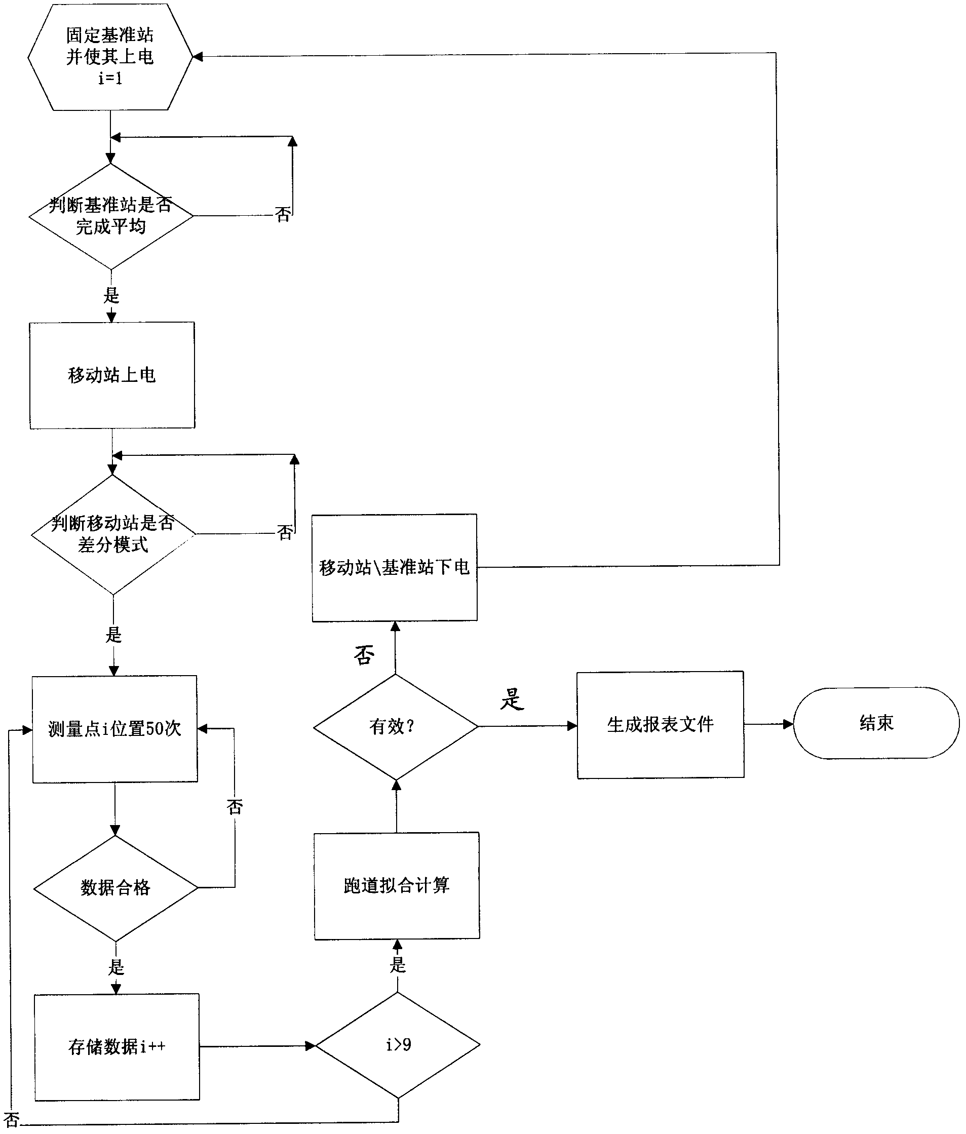
[0028] Specific embodiments of the present invention will be further described in detail below in conjunction with the accompanying drawings.

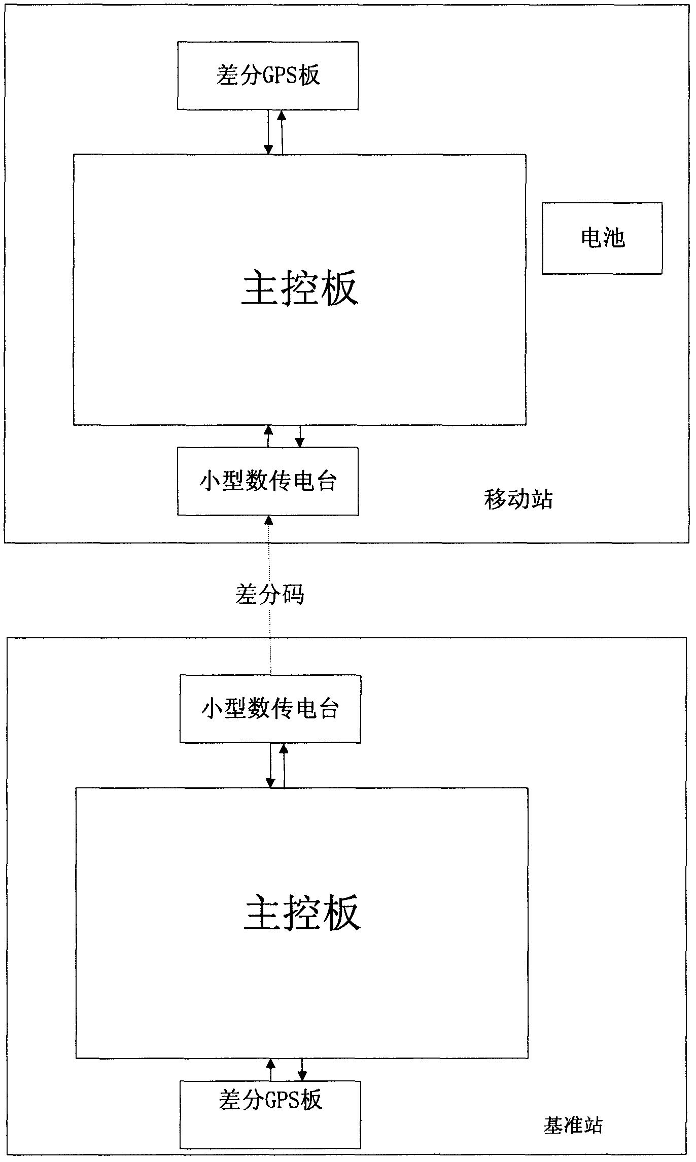
[0029] like figure 1 As shown, the present invention provides a system for determining the runway of an unmanned aerial vehicle. The system includes a base station and a mobile station. board, battery and case; base station and mobile communicate via radio link.

[0030] The differential GPS board, digital radio board, main control board and battery are all fixed in the case, and the battery supplies power for the differential GPS board, digital radio board and main control board, and the main control board and differential GPS board are connected through PC104 bus. The board and the digital transmission board are connected through RS232 serial communication;

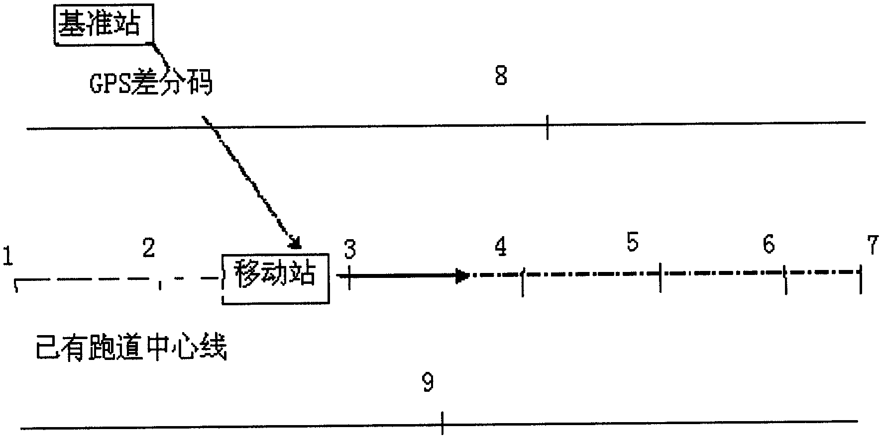
[0031] The differential GPS board of the base station is used to generate the differential code (the base station obtains the differential code by averaging the GPS coordinate...


PUM


Abstract

The invention relates to a system and a method for determining an airfield runway of an unmanned plane. The system consists of a reference station and a mobile station, wherein the reference station and the mobile station are of the same construction and comprise main control boards, differential GPS (Global Positioning System) boards, digital transmission radio boards and the like. The referencestation is used for obtaining a GPS differential code and sending the GPS differential code to the mobile station through a radio link, so that the positioning accuracy of the mobile station is improved. The mobile station is used for acquiring the GPS data of specified positions of the airfield runway and obtaining the length, width and runway centerline of the airfield runway by using an average and fitting algorithm. According to the system and the method for determining the airfield runway of the unmanned plane, the effect for measuring and processing data of the airfield runway can be quantitatively evaluated instantaneously.

Description

technical field [0001] The invention relates to a system and method for determining the runway of an unmanned aerial vehicle, which are used to provide accurate runway parameters for the takeoff and landing of the unmanned aerial vehicle. Background technique [0002] Currently known UAV airport runway position and heading information calibration methods use a real system (UAV) to measure (the UAV is manually pushed on the existing runway to measure the UAV's runway) or use various general-purpose Surveying and mapping methods have a low degree of automation, high labor intensity, and low work efficiency, and the calibration effect cannot be quickly given a quantitative judgment. Contents of the invention [0003] The technical problem of the present invention is to overcome the deficiencies of the prior art, provide a system and method for determining the runway of the UAV airport, reduce the labor intensity of airport runway calibration, improve work efficiency, and ensu...

Claims


Application Information

Patent Timeline
Patent Type & Authority Applications(China)
IPC IPC(8): G01S19/44G01S19/41
Inventor 胡强成海朋
Owner CAIHONG DRONE TECH CO LTD
Why Eureka
Try Eureka