Eureka AIR delivers breakthrough ideas for toughest innovation challenges, trusted by R&D personnel around the world.

Landslide susceptibility evaluation method based on topographic units

A technology of susceptibility and terrain, applied in the direction of instruments, data processing applications, design optimization/simulation, etc., can solve problems such as poor reliability of landslides, and achieve reliable research results

Active Publication Date: 2021-09-17
HENAN UNIVERSITY
View PDF8 Cites 0 Cited by
  • Summary
  • Abstract
  • Description
  • Claims
  • Application Information

AI Technical Summary

Problems solved by technology

[0004] Aiming at the problem of poor reliability of existing landslide susceptibility evaluation methods, the present invention provides a landslide susceptibility evaluation method based on terrain units

Method used


Image

  • Landslide susceptibility evaluation method based on topographic units
  • Landslide susceptibility evaluation method based on topographic units
  • Landslide susceptibility evaluation method based on topographic units

Examples


Embodiment Construction

[0045] The following will clearly and completely describe the technical solutions in the embodiments of the present invention with reference to the accompanying drawings in the embodiments of the present invention. Obviously, the described embodiments are only some, not all, embodiments of the present invention. Based on the embodiments of the present invention, all other embodiments obtained by persons of ordinary skill in the art without creative efforts fall within the protection scope of the present invention.

[0046] It should be noted that, in the case of no conflict, the embodiments of the present invention and the features in the embodiments can be combined with each other.

[0047] The present invention will be further described below in conjunction with the accompanying drawings and specific embodiments, but not as a limitation of the present invention.

[0048] The landslide susceptibility evaluation method based on terrain unit of the present embodiment, described...


PUM


Abstract

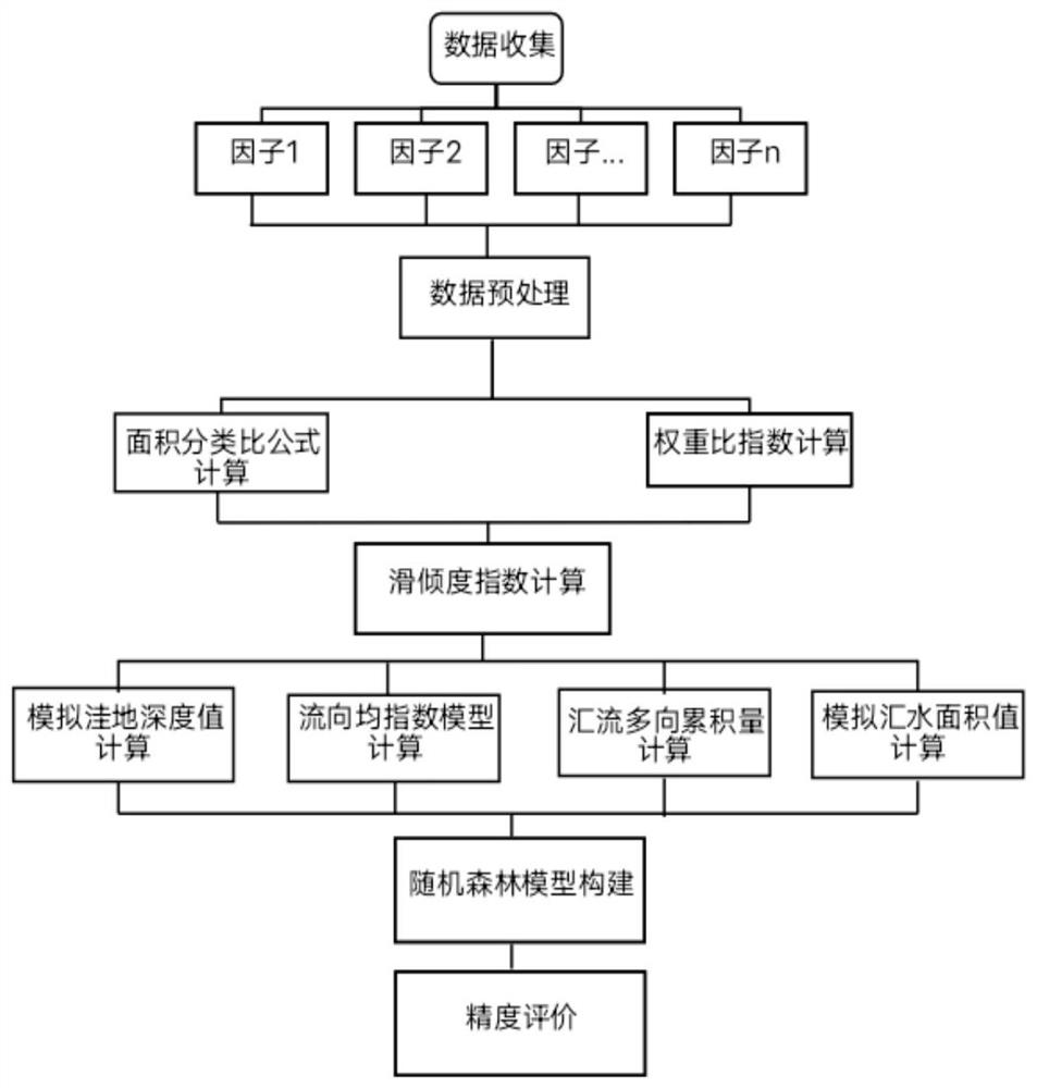
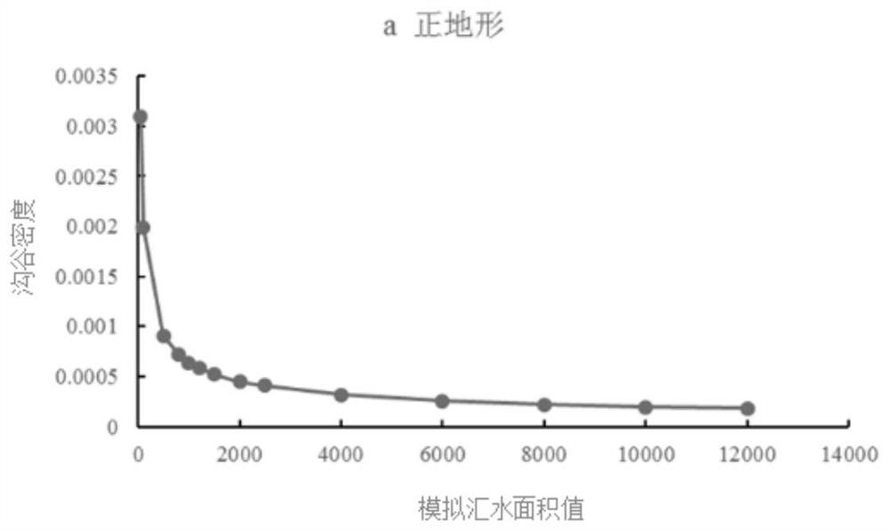
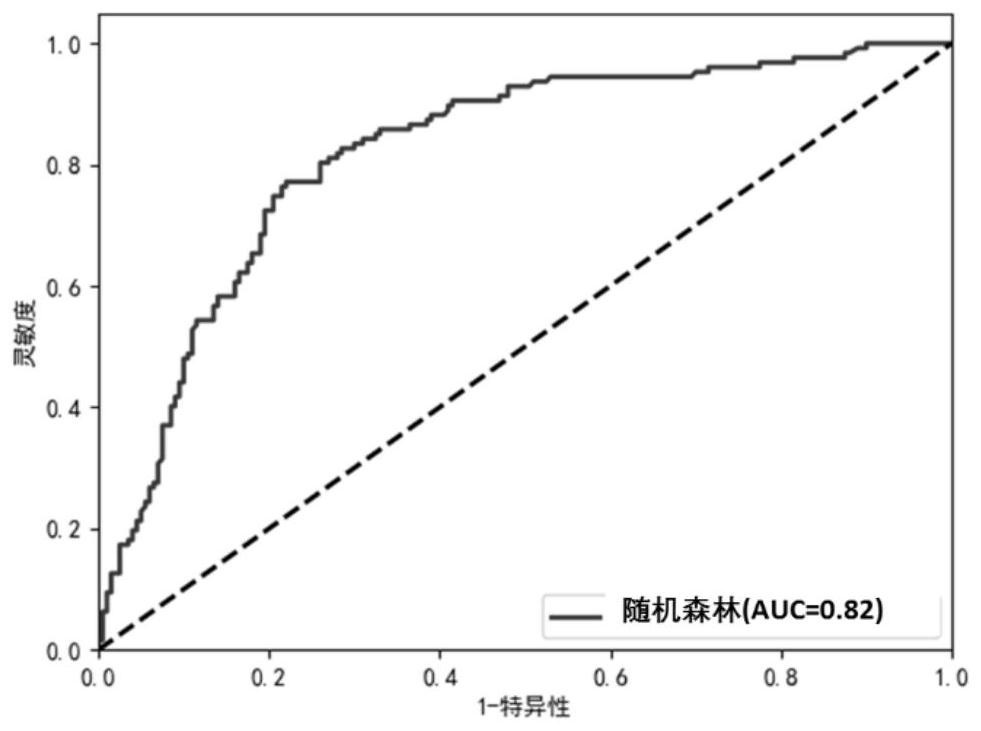
The invention discloses a landslide susceptibility evaluation method based on terrain units, solves the problem of poor reliability of an existing landslide susceptibility evaluation method, and belongs to the field of regional geological disaster evaluation. The method comprises the following steps: determining a landslide point position and related disaster-inducing factor data; acquiring discrete intervals of the disaster-inducing factor data, wherein each discrete interval corresponds to a classification category, and the intervals are optimized by adopting intersection points and inflection points of an area classification ratio curve and a weight ratio index curve; carrying out statistics on the optimized discrete interval area and the corresponding landslide point number, and obtaining a slip inclination index; constructing a river network by using a terrain surface model DEM; constructing a terrain unit according to the river network; assigning the slip degree index of each optimization interval of each disaster-inducing factor to each terrain unit; and establishing a random forest model, in which the input is the data of each terrain unit, and the output is the landslide susceptibility probability value of each terrain unit.

Description

technical field [0001] The invention relates to a landslide susceptibility evaluation method based on terrain units, which belongs to the field of regional geological disaster evaluation in earth system science. Background technique [0002] Landslide susceptibility evaluation is the basis for landslide geological disaster prevention and control, and landslide hazard factors and landslide evaluation unit division are the two most important components in landslide susceptibility evaluation. The analysis of landslide hazard factors is the primary task of regional landslide disaster risk assessment and prevention and control. At the same time, there are still some problems in the division of landslide susceptibility evaluation units. There is no unified division standard, which leads to the reliability of landslide susceptibility evaluation methods. Poor sex. [0003] Landslide occurrence itself is a relatively complicated process, and the construction of a scientific suscepti...

Claims


Application Information

Patent Timeline
Patent Type & Authority Applications(China)
IPC IPC(8): G06F30/27G06K9/62G06Q10/06G06Q50/26G06F111/10
CPCG06F30/27G06Q10/0635G06Q50/265G06F2111/10G06F18/24323
Inventor 崔耀平李梦迪邱林单燕祥朱连奇史志方张香
Owner HENAN UNIVERSITY
Why Eureka
Eureka Blog
Learn More