Method for adjusting position of airspace boundary point

An adjustment method and boundary point technology, applied in the field of data processing, can solve problems such as batch processing of airspace boundary points, and achieve the effect of eliminating high coupling

Active Publication Date: 2021-09-24
中航材导航技术(北京)有限公司
View PDF7 Cites 0 Cited by
  • Summary
  • Abstract
  • Description
  • Claims
  • Application Information

AI Technical Summary

Problems solved by technology

[0005] For this reason, the present invention provides a method for adjusting the position of airspace boundary points, which can quickly adjust all airspace boundaries and ensure that the distance between boundary points and adjacent airspace boundaries meets the accuracy requirements, and solves the problem that airspace boundary points cannot be batched by automated methods. Dealing with difficult problems

Method used


Image

  • Method for adjusting position of airspace boundary point
  • Method for adjusting position of airspace boundary point
  • Method for adjusting position of airspace boundary point

Examples


Embodiment Construction

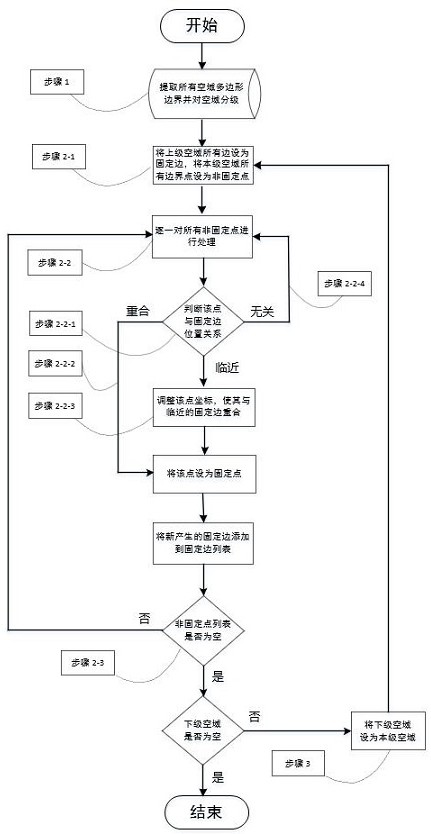
[0030] In order to make the purpose, technical solution and advantages of the present invention clearer, the present invention will be further described in detail below in conjunction with the accompanying drawings and specific embodiments. It should be understood that the specific embodiments described here are only used to explain the present invention, not to limit the present invention.

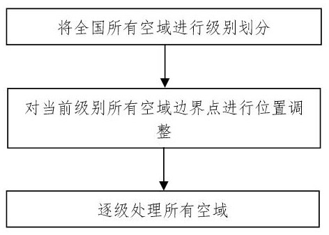
[0031] The reasonable division of civil aviation domain is the guarantee to ensure the safe and orderly operation of aircraft. At present, the traditional method of delineating or adjusting the boundary points of civil aviation in my country mainly relies on manually drawing points on the two-dimensional aeronautical chart. The coordinate error of the boundary points produced by this method is relatively large, and a large number of airspace boundary points do not coincide with the adjacent airspace boundaries. , there are significant gaps or overlaps between airspaces. Moreover, when adj...


PUM


Abstract

The invention discloses an airspace boundary point position adjusting method. The method comprises the following steps: performing level division on all airspaces throughout the country; performing position adjustment on all airspace boundary points of the current level; and processing all airspaces step by step. According to the invention, boundary point position adjustment can be conveniently carried out on each level of airspace throughout the country, and all boundary points are ensured to coincide with adjacent airspace boundaries. The method can be applied to the fields of airspace fine management, 4D track analysis and the like.

Description

technical field [0001] The invention relates to the technical field of data processing, in particular to a method for adjusting the position of an airspace boundary point. Background technique [0002] Airspace is the place where all air transportation takes place. Civil aviation management generally divides command authority and allocates airspace resources according to airspace boundaries. The accuracy of the airspace boundary is directly related to the safety and efficiency of air transportation. my country's airspace is mainly divided into information areas, control areas, control sectors, approach control areas, approach control sectors and other types. [0003] At present, the traditional method of delineating or adjusting the boundary points of civil aviation in my country mainly relies on manually drawing points on the two-dimensional aeronautical chart. The coordinate error of the boundary points produced by this method is relatively large, and a large number of ai...

Claims


Application Information

Patent Timeline
Patent Type & Authority Applications(China)
IPC IPC(8): G08G5/00
CPCG08G5/0095
Inventor 宋柯
Owner 中航材导航技术(北京)有限公司
Why Eureka
Try Eureka