Multi-satellite region observation planning method based on adaptive genetic algorithm

A genetic algorithm and self-adaptive technology, applied in the field of multi-satellite regional observation planning based on self-adaptive genetic algorithm, can solve problems such as large computational burden and search burden, unfavorable scheme combination, large stripe, etc.

Active Publication Date: 2021-11-26
HEFEI UNIV OF TECH
View PDF10 Cites 1 Cited by
  • Summary
  • Abstract
  • Description
  • Claims
  • Application Information

AI Technical Summary

Problems solved by technology

However, the grid discretization method is difficult to directly determine the optimal grid granularity in use, and the determination of the grid granularity is determined empirically in most practical applications
When the granularity of grid division is large, the strips constructed on this basis will be relatively sparse, which is not conducive to the combination of schemes; when the granularity of grid division is small, a large number of grids will be generated, resulting in The strips are not only large in number, but also very densely arranged in position, which will cause a large calculation burden and search burden

Method used


Image

  • Multi-satellite region observation planning method based on adaptive genetic algorithm
  • Multi-satellite region observation planning method based on adaptive genetic algorithm
  • Multi-satellite region observation planning method based on adaptive genetic algorithm

Examples


Embodiment Construction

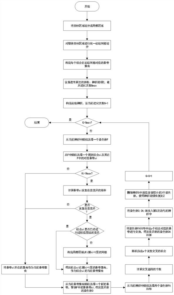
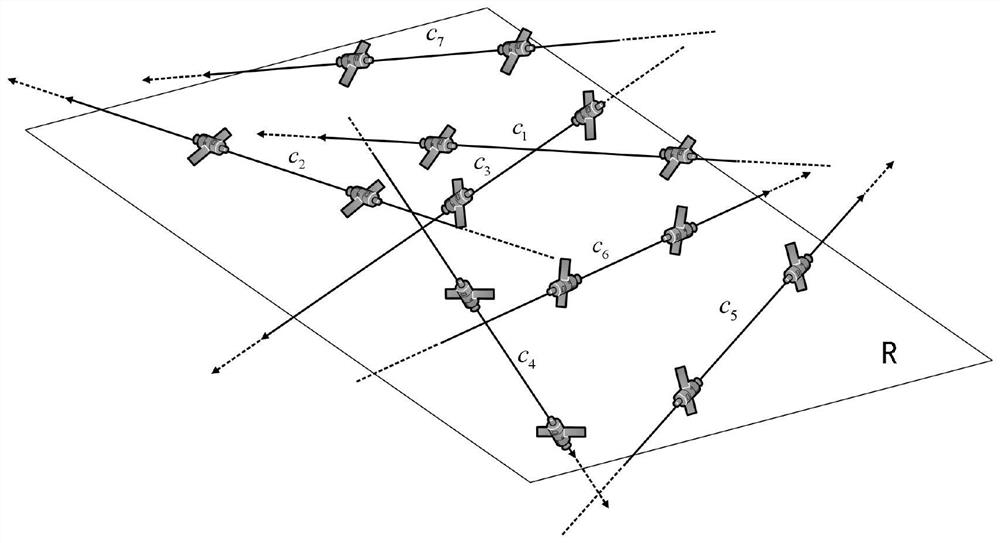
[0046] In this example, if figure 2 As shown, a multi-satellite regional observation planning method based on adaptive genetic algorithm is applied to the observation task where multiple satellites jointly observe a target area R, assuming that the observation time window set of all satellites is C={c 1 ,c 2 ,...,c i ,...,c n},c i Indicates the i-th observation opportunity, n indicates the total number of observation opportunities; use |R| to indicate the area of ​​the target region R; use Indicates the i-th observation opportunity c i The corresponding local area; use K to represent the current grid level, and set the maximum nesting level to K max ;use Indicates the i-th observation opportunity c i Constitute a set of strips on the K-th layer grid, where, Indicates the i-th observation opportunity c i The j-th strip constructed on the K-th layer, Indicates the i-th observation opportunity c i The number of stripes constructed at layer K; for example figure 1...


PUM


Abstract

The invention discloses a multi-satellite region observation planning method based on an adaptive genetic algorithm, the method comprises the following steps: 1, combining a local grid nesting method with a genetic algorithm, and reducing unnecessary redundancy and repeated calculation by searching grids and strip information stored by a group; 2, providing a double-layer genetic coding mode, and effectively representing an observation scheme formed by strips selected from different levels; 3, providing an adaptive probability function, and adaptively determining whether a local area needs to be nested according to information of an existing solution; 4, obtaining a new feasible observation scheme through variation and crossover operation, and improving population diversity. According to the method, a multi-satellite region observation strip scheme with a relatively high coverage rate can be quickly obtained by only occupying relatively few computing resources, and the utilization efficiency of satellite resources is improved.

Description

technical field [0001] The invention belongs to the field of satellite mission planning, in particular to a multi-satellite regional observation planning method based on an adaptive genetic algorithm. Background technique [0002] Earth Observation Satellite (EOS: Earth Observation Satellite), or imaging satellite (hereinafter referred to as "satellite"), one of its main functions is to monitor land, ocean, atmosphere, Wait for observation. Observation needs are proposed by users from various fields and departments such as agriculture, forestry, ocean, land, environmental protection, meteorology, etc., and are summarized in the satellite ground control center. The imaging observation plan, and generate measurement and control instructions, and upload them to the satellite through the ground measurement and control station. After receiving the instruction, the satellite will take corresponding actions to image the designated area. When communicating with the ground station,...

Claims


Application Information

Patent Timeline
Patent Type & Authority Applications(China)
IPC IPC(8): G06Q10/06G06Q50/26G06N3/12
CPCG06Q10/0637G06Q50/26G06N3/126Y02A90/10
Inventor 胡笑旋伍艺夏维孙海权
Owner HEFEI UNIV OF TECH
Why Eureka
Try Eureka