Seamless geocoding mapping method and system for side-scan sonar

A technology of geocoding and side-scan sonar, applied in the direction of radio wave measurement system, sound wave re-radiation, instruments, etc., can solve the problems of loss of detailed information, and will not improve the gap and cross phenomenon

Pending Publication Date: 2022-01-21
武汉长江航道救助打捞局 +2
View PDF0 Cites 2 Cited by
  • Summary
  • Abstract
  • Description
  • Claims
  • Application Information

AI Technical Summary

Problems solved by technology

The data of the vertical track of the side scan sonar has a relatively high resolution. The above processing method will lose some details in the original data, and when the heading changes significantly, it will not improve the appearance of the edges on both sides of the scan line on the coded image. gaps and intersections

Method used


Image

  • Seamless geocoding mapping method and system for side-scan sonar
  • Seamless geocoding mapping method and system for side-scan sonar
  • Seamless geocoding mapping method and system for side-scan sonar

Examples


Embodiment Construction

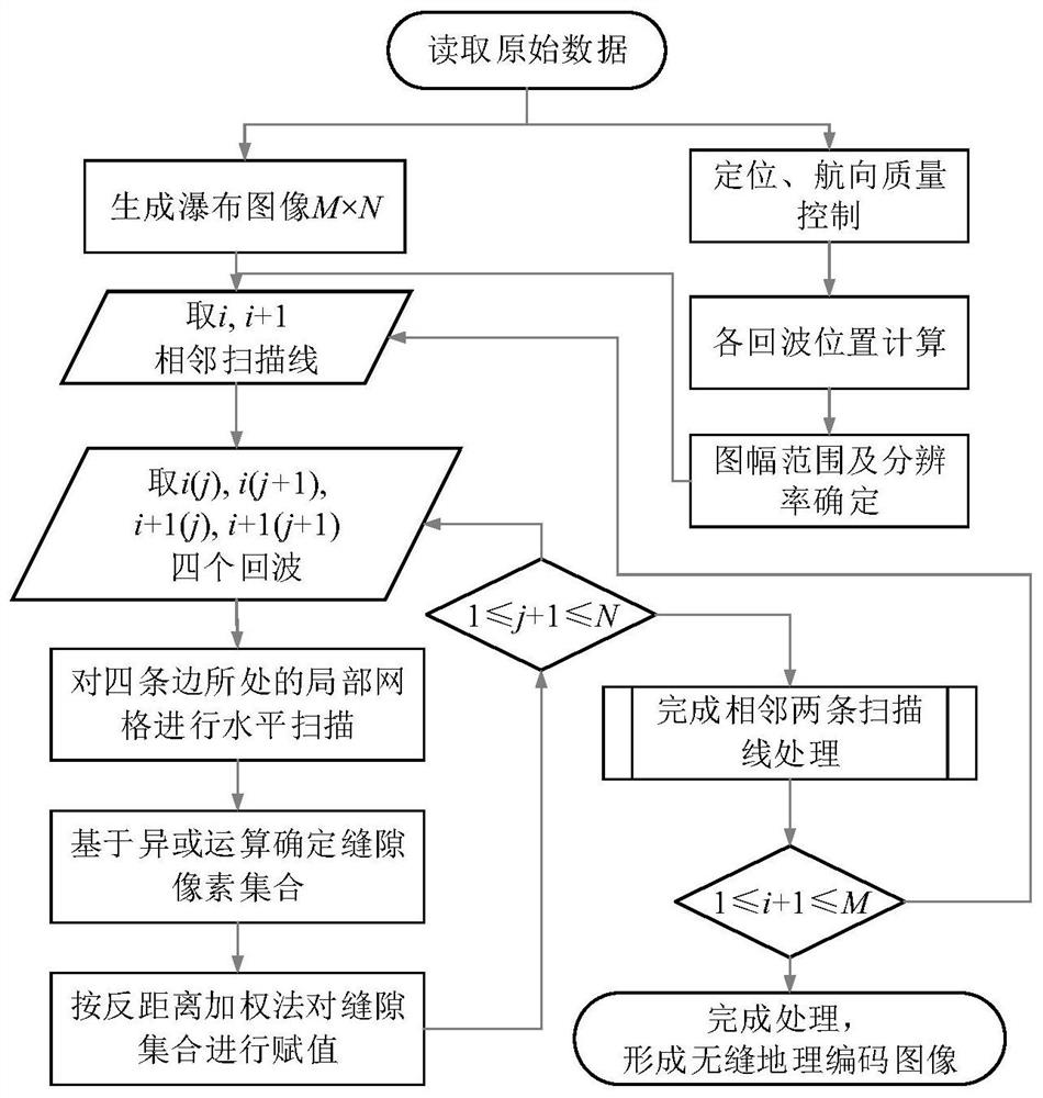
[0035] Various exemplary embodiments of the present invention will be described in detail below with reference to the accompanying drawings. It should be noted that the relative arrangements of components and steps, numerical expressions and numerical values ​​set forth in these embodiments do not limit the scope of the present invention unless specifically stated otherwise.

[0036] At the same time, it should be understood that, for the convenience of description, the sizes of the various parts shown in the drawings are not drawn according to the actual proportional relationship.

[0037] The following description of at least one exemplary embodiment is merely illustrative in nature and in no way taken as limiting the invention, its application or uses.

[0038] In order to make the object, technical solution and advantages of the present invention clearer, the present invention will be described in further detail below in conjunction with specific embodiments and with refer...


PUM


Abstract

The invention provides a seamless geocoding mapping method and system for a side-scan sonar, and the method comprises the steps: reading the original data of a side-scan sonar image, and forming a waterfall image through horizontal stacking; extracting channel data; performing quality control and interpolation on the channel data, and calculating the position of the tow fish based on the consistency of the tow fish and the course of the ship body; calculating the echo position of the side-scan sonar image according to the tow fish position and the ship course; determining a mapsheet range according to the echo position, setting a mapping resolution, and determining a pixel space of the coded image; traversing and extracting two pairs of adjacent echoes on adjacent scanning lines in the waterfall image, determining four-corner pixel positions of the two pairs of echoes in a pixel space, and constructing a local grid cache region covering the four-corner pixel positions; and scanning the local grid cache region, carrying out XOR operation on a scanning result to obtain a gap pixel set, and carrying out intensity assignment on the gap pixel set to obtain a seamless side-scan sonar geocoded image.

Description

technical field [0001] The invention relates to the technical field of underwater sonar mapping, in particular to a method and system for seamless geocoding and mapping of side-scan sonar. Background technique [0002] The side-scan sonar system uses a double-line array to scan the seabed targets within a certain opening angle range below the towfish, forming time-series echoes distributed along the slant distance, which are displayed on the image as a vertical track direction centered on the towfish. The scanning lines are stacked vertically according to the navigation order to form a side-scan sonar waterfall image. [0003] The side-scan sonar waterfall image does not have an intuitive position and orientation, and the waterfall image needs to be geocoded for ease of use. Due to the limitation of ship speed change and distance mapping, the vertical and horizontal echo resolutions of side scan sonar are inconsistent, and there are gaps between adjacent scan lines of side ...

Claims


Application Information

Patent Timeline
Patent Type & Authority Applications(China)
IPC IPC(8): G01S15/89
CPCG01S15/8902
Inventor 程智慧曾威王爱学刘畅张晓冬张亮周玉夏开奇邱昊李波车远超段文杰严海文林文军康路遥
Owner 武汉长江航道救助打捞局
Why Eureka
Try Eureka