
Method and system for collecting and updating data of riding map

A technology for map data and data collection, applied in database update, geographic information database, structured data retrieval, etc., can solve the problems of slow real-time update rate, low map data collection accuracy, affecting user experience, etc., to achieve intelligent Effect

Inactive Publication Date: 2022-02-08
安徽宇呈数据技术有限公司
View PDF6 Cites 0 Cited by
  • Summary
  • Abstract
  • Description
  • Claims
  • Application Information

AI Technical Summary

Problems solved by technology

Solve the technical problems in the prior art that the accuracy of map data collection based on walking and riding is low, and the real-time update rate is slow, which affects the user experience

Method used


Image

  • Method and system for collecting and updating data of riding map
  • Method and system for collecting and updating data of riding map
  • Method and system for collecting and updating data of riding map

Examples


Embodiment 1

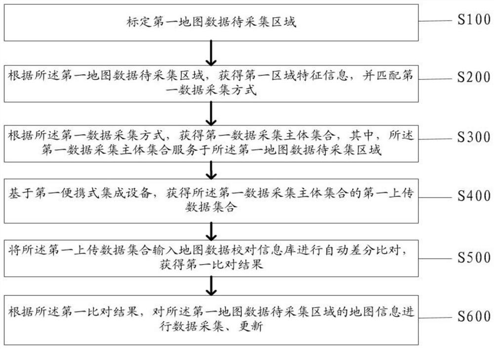
[0031] Such as figure 1 As shown, the embodiment of the present application provides a method for collecting and updating bicycling map data, wherein the method includes:

[0032] Step S100: Demarcate the area to be collected of the first map data;

[0033] Step S200: According to the area to be collected by the first map data, obtain the first area characteristic information, and match the first data collection method;

[0034] Specifically, the map (Map) scientifically reflects the distribution characteristics and interrelationships of natural and social economic phenomena according to certain rules. Use portable devices to collect and update bicycling map data. The most basic thing is to know the target area that needs to be updated. Only by knowing the target area can you better add or reduce POI information such as commercial streets and office buildings in the area. Collect and update. Therefore, the system should obtain the area to be collected on the map, and mark th...

Embodiment 2

[0090] Based on the same inventive concept as the method for realizing the data collection and updating of the walking and riding map in the foregoing embodiments, the present invention also provides a system for realizing the collecting and updating of the walking and riding map data, such as Figure 8 As shown, the system includes:

[0091] The first marking unit 11, the first marking unit 11 is used to mark the area to be collected by the first map data;

[0092] A first obtaining unit 12, the first obtaining unit 12 is configured to obtain the first area feature information according to the area to be collected by the first map data, and match the first data collection method;

[0093] A second obtaining unit 13, the second obtaining unit 13 is configured to obtain a first data collection subject set according to the first data collection method, wherein the first data collection subject set serves the first map data the area to be collected;

[0094] A third obtaining u...


PUM


Abstract

The invention discloses a method and a system for acquiring and updating data of a riding map. The method comprises the following steps: calibrating a first map data to-be-acquired area; according to the first map data to-be-collected area, acquiring first area feature information and matching a first data collection mode; acquiring a first data collection main body set according to the first data collection mode, and acquiring a first uploaded data set of the first data collection main body set based on a first portable integrated device; inputting the first uploaded data set into a map data proofreading information base for automatic differential comparison to obtain a first comparison result; and according to the first comparison result, carrying out data acquisition and updating on the map information of the first map data to-be-acquired area. According to the invention, the technical problems that the accuracy of map data collection based on step riding is low, a real-time updating speed is low, and then user experience is affected in the prior art are solved.

Description

technical field [0001] The invention relates to the technical field of map collection, in particular to a method and system for realizing data collection and updating of walking and cycling maps. Background technique [0002] The traditional map industry is labor-intensive in nature, and all data is obtained by field data collectors (outside) collecting data, and indoor processing personnel (office) processing data. Maps represent elements such as mountains, rivers, and green areas. Mainly used for display, the need for updates is extremely low, and can be obtained at one time. In recent years, methods including crowdsourcing of driving recorders, AI assistance, and internal industry outsourcing have emerged, but they still cannot get rid of labor-intensive path dependence in essence. Emerging markets basically have not gone through decades of industrialization similar to China, resulting in extremely low industrial literacy of the low-end population, and it is difficult t...

Claims


Application Information

Patent Timeline
Patent Type & Authority Applications(China)
IPC IPC(8): G06F16/29G06F16/23G06F16/27
CPCG06F16/29G06F16/23G06F16/27
Inventor 陈文静任轶闫鸿昌张学森罗自贤王东升
Owner 安徽宇呈数据技术有限公司
Learn More