Sea chart selection method and device based on planned route
A technology for selecting devices and nautical charts, applied in the field of navigation and navigation, can solve the problem of low safety of ship navigation, and achieve the effect of improving safety
Pending Publication Date: 2022-02-11
广州海宁海务技术咨询有限公司
6 Cites 0 Cited by
AI-Extracted Technical Summary
Problems solved by technology
[0003] Aiming at the problems existing in the prior art, the present invention provides a sea chart sele...
Method used
Carry out the embodiment of the present invention, can determine the convoy area that contains the planned route based on the planned route obtained and the preset yaw distance, and obtain each chart icon that intersects with the convoy area, and finally obtain The nautical chart corresponding to each nautical chart symbol obtained is determined as the nautical chart corresponding to the planned route, so that the ship can obtain an accurate nautical chart during the navigation process, and the safety of the ship navigation is improved. And, implementing the above implementation manners can also improve the accuracy of determining the planned route. And, implementing the above implementation manner can also ensure the accuracy of determining the chart icon inters...
Abstract
The invention discloses a sea chart selection method and device based on a planned route. The method comprises the following steps of determining a escorting region corresponding to the planned route based on the obtained planned route and a preset yaw distance, and the escorting region comprising the planned route; obtaining a sea chart icon which has an intersection with the escorting region; and determining the sea chart corresponding to the sea chart icon as the sea chart corresponding to the planned route. The method can determine the escorting region including the planned route based on the obtained planned route and the preset yaw distance, obtains each sea chart icon having intersection with the escorting region, and finally determines the sea chart corresponding to each obtained sea chart icon as the chart corresponding to the planned route. a ship can obtain the accurate sea chart in the sailing process, and sailing safety of the ship is improved.
Application Domain
Navigational calculation instruments
Technology Topic
Marine engineeringOceanography
Image
Examples
- Experimental program(1)
Example Embodiment
[0055] The technical solutions in the embodiments of the present invention will be clearly and completely described below with reference to the accompanying drawings in the embodiments of the present invention. Obviously, the described embodiments are only a part of the embodiments of the present invention, but not all of the embodiments. Based on the embodiments of the present invention, all other embodiments obtained by those of ordinary skill in the art without creative efforts shall fall within the protection scope of the present invention.
[0056] It should be noted that the terms "comprising" and "having" in the embodiments of the present invention and the accompanying drawings, as well as any modifications thereof, are intended to cover non-exclusive inclusion. For example, a process, method, system, product or device comprising a series of steps or units is not limited to the listed steps or units, but optionally also includes unlisted steps or units, or optionally also includes For other steps or units inherent to these processes, methods, products or devices.
[0057]The embodiments of the present invention disclose a method and device for selecting a chart based on a planned route, which can enable a ship to obtain an accurate chart during the navigation process and improve the safety of the ship's navigation. Each of them will be described in detail below.
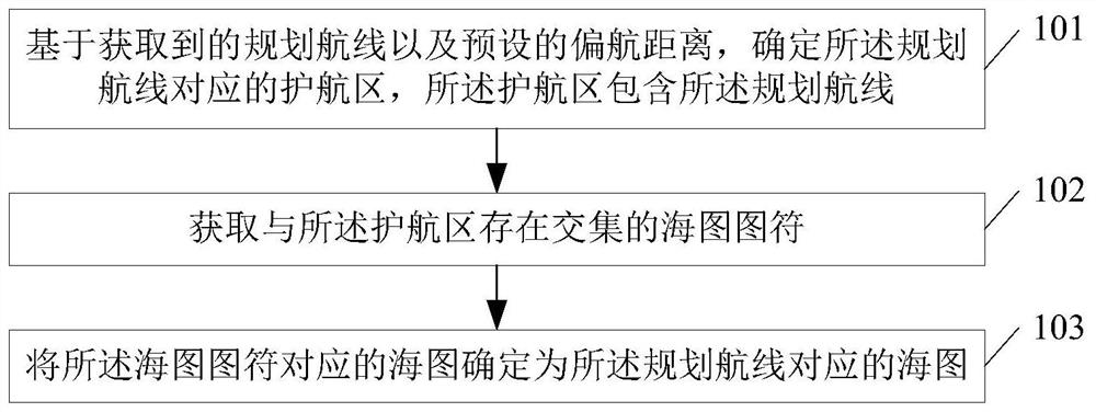
[0058] see figure 1 , figure 1 It is a schematic flowchart of a method for selecting a chart based on a planned route disclosed by an embodiment of the present invention. like figure 1 As shown, the method for selecting a chart based on a planned route may include the following steps:
[0059] 101. Based on the acquired planned route and a preset yaw distance, determine an escort area corresponding to the planned route, where the escort area includes the planned route;
[0060] In the embodiment of the present invention, the chart of the route area of the planned route can be obtained according to the planned route, thereby ensuring that the ship can navigate according to the obtained chart as a reference during the process of traveling according to the planned route, thereby improving the safety of navigation . Since the ship may be affected by strong winds and currents during the navigation process, the actual route of the ship may deviate from the planned route. At this time, there may be a situation where the chart is not pre-obtained at the actual route that deviates from the planned route. The navigation of the ship is carried out accurately, which reduces the safety of the ship's navigation.
[0061] In this embodiment of the present invention, the preset yaw distance can be obtained, and the preset yaw distance can be calculated by feeling the distance between the historical planned route obtained when the ship sailed in the past and the actual route. The distance can reflect the distance that the ship will usually yaw against the planned route during the voyage.
[0062] Also, the escort area may be a rectangular escort area or a circular escort area, which is not limited in the embodiment of the present invention. When the escort area is determined as a rectangular escort area, the planned route can be determined as the center line of the escort area, and the length of the planned route can be determined as the length of the long side of the escort area, and the left and right sides of the planned route can be When extending, the extended distance can be the preset yaw distance. Therefore, twice the preset yaw distance can be determined as the length of the broad side of the escort area, thereby determining the escort area corresponding to the planned route.
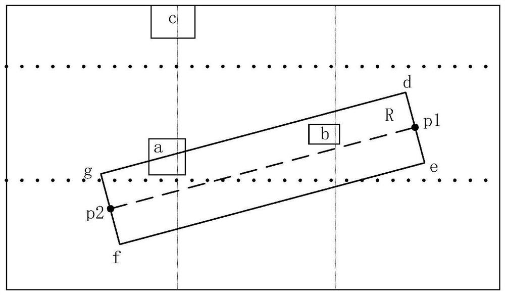
[0063] Please also refer to image 3 , image 3 is a schematic diagram of a scenario of chart selection based on a planned route disclosed in an embodiment of the present invention, wherein the planned route can be obtained by the line segment p1p2, and the lengths of the line segment p1d and the line segment p1e can both be the length of the preset yaw distance, The rectangle defh can be the escort area corresponding to the determined planned route. It can be seen that the planned route can be the center line of the escort area, and the length of the long side of the escort area can be the length of the planned route, and the length of the wide side of the escort area can be doubled the preset yaw distance.
[0064] 102. Acquire a chart icon that intersects with the escort area;
[0065] In this embodiment of the present invention, the information that the nautical chart icons can be used to mark includes, but is not limited to, facilities, reefs, seabed topography, and islands that appear around the navigation route, and the information marked by the nautical chart icons can be used for reference to actual navigation , to avoid the collision of ships, and the chart icon can be a mark of regular graphics or irregular graphics, and the area size of the chart symbol can also be determined according to the size and shape of the actual marked object. At this time, you can Determine the chart icon that intersects with the escort area as the chart icon that needs to be acquired. The chart icon that intersects with the escort area can be the escort area that completely contains the chart icon, or it can be the one with the chart icon. Parts of the area are located anywhere within the convoy.
[0066] 103. Determine the nautical chart corresponding to the nautical chart symbol as the nautical chart corresponding to the planned route.
[0067] In the embodiment of the present invention, in order to accurately record the position of the chart icon, the chart icon is usually determined as the chart corresponding to the area where the chart icon is located, so that the position of the chart icon can be more accurate. The preparation is recorded, so the chart corresponding to the planned route can be determined according to the obtained chart corresponding to the chart symbol that intersects with the escort area, that is, the chart corresponding to the planned route can be the obtained chart. the corresponding chart.
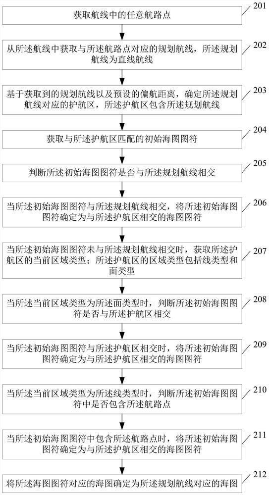
[0068] see figure 2 , figure 2 It is a schematic flowchart of another method for selecting a chart based on a planned route disclosed in an embodiment of the present invention. like figure 2 As shown, the method for selecting a chart based on a planned route may include the following steps:
[0069] 201. Obtain any waypoint in the route;
[0070] 202. Acquire a planned route corresponding to the waypoint from the route, where the planned route is a straight route.
[0071] By implementing the above steps 201 to 202, the planned route corresponding to the waypoint can be determined according to any waypoint in the route, which improves the accuracy of determining the planned route.
[0072] In the embodiment of the present invention, all the routes can be pre-divided into multiple flight segments, thereby improving the management efficiency of the routes, and the waypoints can be in any segment of all the routes. The target flight segment corresponding to the waypoint, and the planned route can be obtained from the target flight segment, and the planned route can be a straight route.
[0073] 203. Based on the obtained planned route and a preset yaw distance, determine an escort area corresponding to the planned route, where the escort area includes the planned route;
[0074] 204. Obtain an initial chart icon matching the convoy area;
[0075] 205. Determine whether the initial chart icon intersects the planned route;
[0076] 206. When the initial nautical chart icon intersects the planned route, determine the initial nautical chart icon as the nautical chart icon intersecting with the convoy area.
[0077] By implementing the above steps 204 to 206, the initial chart icon intersecting with the planned route can be determined as the chart symbol intersecting with the escort area, which ensures the accuracy of determining the chart symbol intersecting with the escort area.
[0078] 207. When the initial chart icon does not intersect the planned route, obtain the current area type of the convoy area; the area type of the convoy area includes a line type and a surface type;
[0079] 208. When the current area type is the surface type, determine whether the initial chart icon intersects the escort area;
[0080] 209. When the initial nautical chart icon intersects the convoy area, determine the initial nautical chart icon as the nautical chart icon intersecting the escort area.
[0081] By implementing the above steps 207 to 209, when the escort area is a surface type, the initial chart icon intersecting with the escort area can also be determined as the nautical chart icon that needs to be acquired, which improves the determination of the nautical chart icon intersecting with the escort area. Comprehensiveness of icons.
[0082] In the embodiment of the present invention, the area type of the escort area may include line type and surface type. If the preset yaw distance is 0, it can be considered that the width of the escort area corresponding to the planned route generated according to the yaw distance is 0. Therefore, , it can be considered that the form of the escort area is a straight line, that is, the area type of the escort area is a line type; if the preset yaw distance is not 0, it can be considered that the width of the escort area corresponding to the planned route generated according to the yaw distance is not is 0, therefore, it can be considered that the form of the convoy area is a rectangle, that is, the area type of the convoy area is a surface type.
[0083] 210. When the current area type is the line type, determine whether the initial chart icon includes the waypoint;
[0084] 211. When the initial nautical chart icon includes the waypoint, determine the initial nautical chart icon as the nautical chart icon intersecting the escort area.
[0085] By implementing the above steps 210 to 211, when the escort area is a line type, the initial chart icon including the waypoint can be determined as the chart icon to be identified, which improves the identified chart intersecting with the escort area. Accuracy of icons.
[0086] 212. Determine the nautical chart corresponding to the nautical chart symbol as the nautical chart corresponding to the planned route.
[0087] Please also refer to image 3 , image 3 It is a schematic diagram of a scenario of chart selection based on a planned route disclosed in an embodiment of the present invention, wherein a, b, and c can represent the obtained initial chart icons, and it can be judged first whether there is a sea that intersects with the planned route. If the chart icon does not exist, the area type of the escort area can be obtained. When it is detected that the area type of the escort area is a surface type, it can be judged again whether there is a chart icon that intersects with the escort area. Both chart symbols a and b intersect with the escort area, so both a and b can be determined as the required chart symbols, where part of the chart symbols of a intersects with part of the escort area, and b All of the chart icons of are located in the convoy area; therefore, a and b of the initial chart icons a, b, and c can be determined as the chart icons that intersect the convoy area.
[0088] For example, a waypoint can be obtained from all pre-planned routes, the planned route corresponding to the waypoint can be obtained, and the preset yaw distance can be obtained. Based on the yaw distance, the corresponding planned route can be determined. Convoy area, wherein, when the yaw distance=0, the obtained area type of the convoy area is the line type; when the yaw distance>0, the obtained area type of the convoy area is the surface type. At this time, the specific process of performing chart selection may be as follows:
[0089] Step 1: Obtain all the pre-stored initial chart symbols, determine the number S of all the initial chart symbols, and set the value of the number i of the first initial chart symbol to 0, and the result can be constructed output array result;
[0090] Step 2: When i=S, output the chart corresponding to the chart symbol in the result output array result, and end the chart selection process;
[0091] Step 3: When i
[0092] Step 4: when the initial chart icon numbered i intersects the planned route, input the initial chart icon numbered i into the result output array result, execute i++, and execute step 2;
[0093] Step 5: When the initial chart icon numbered i does not intersect with the planned route, the area type of the initial chart icon numbered i can be obtained;
[0094] Step 6: when the area type of the initial chart icon numbered i is the surface type, determine whether the chart icon of the initial chart icon numbered i intersects the escort area;
[0095] Step 7: When the chart symbol of the initial chart symbol numbered i intersects with the escort area, input the initial chart symbol numbered i into the result output array result, execute i++, and execute step 2 ;
[0096] Step 8: When the chart icon of the initial chart icon numbered i does not intersect the escort area or the area type of the initial chart icon numbered i is line type, determine the initial chart icon numbered i Whether the symbol contains waypoints;
[0097] Step 9: when the initial chart icon numbered i contains waypoints, input the initial chart icon numbered i into the result output array result, execute i++, and perform step 2;
[0098] Step 10: When the initial chart symbol numbered i does not contain a waypoint, execute i++ and execute step 2.
[0099] By implementing the embodiment of the present invention, it is possible to determine an escort area including the planned route based on the acquired planned route and the preset yaw distance, and to acquire each chart icon that has an intersection with the escort area, and finally to obtain each nautical chart icon. The nautical chart corresponding to a nautical chart symbol is determined as the nautical chart corresponding to the planned route, so that the ship can obtain an accurate nautical chart during the navigation process, and the safety of the ship's navigation is improved. And, by implementing the above-mentioned embodiments, the accuracy of determining the planned route can also be improved. And, by implementing the above-mentioned embodiments, the accuracy of the determination of the nautical chart symbols intersecting with the escort area can also be ensured. And, by implementing the above-mentioned embodiments, the comprehensiveness of determining the chart symbols intersecting with the convoy area can also be improved. And, by implementing the above-mentioned embodiments, the accuracy of the identified chart icons intersecting with the escort area can also be improved.
[0100] see Figure 4 , Figure 4 It is a schematic structural diagram of a chart selection device based on a planned route disclosed in an embodiment of the present invention. like Figure 4 As shown, the chart selection device based on the planned route may include:
[0101] a first determining unit 401, configured to determine an escort area corresponding to the planned route based on the acquired planned route and a preset yaw distance, where the convoy area includes the planned route;
[0102] a first obtaining unit 402, configured to obtain a chart icon that has an intersection with the convoy area determined by the first determining unit 401;
[0103] The second determining unit 403 is configured to determine the chart corresponding to the chart symbol obtained by the first obtaining unit 402 as the chart corresponding to the planned route.
[0104] As an optional implementation manner, the chart selection device based on the planned route may further include:
[0105] a second acquiring unit, configured to acquire any waypoint in the route before the first determining unit determines the escort area corresponding to the planned route based on the acquired planned route and the preset yaw distance;
[0106] The second obtaining unit is further configured to obtain a planned route corresponding to the waypoint from the route, where the planned route is a straight route.
[0107] In the embodiment of the present invention, the planned route corresponding to the waypoint can be determined according to any waypoint in the route, which improves the accuracy of determining the planned route.
[0108] As an optional implementation manner, the first obtaining unit 402 may include:
[0109] an acquisition subunit, used for acquiring the initial chart icon matching the convoy area;
[0110] a judging subunit for judging whether the initial chart icon intersects the planned route;
[0111] A determination subunit, configured to determine the initial chart icon as a chart icon intersecting with the convoy area when the result of the determination subunit is yes.
[0112] Wherein, by implementing this embodiment, the initial chart symbol intersecting with the planned route can be determined as the chart symbol intersecting with the escort area, which ensures the accuracy of determining the chart symbol intersecting with the escort area.
[0113] As an optional implementation manner, the area types of the convoy area include line types and surface types, and the chart selection device based on the planned route may further include:
[0114] a third acquiring unit, configured to acquire the current area type of the escort area when the result of the judgment subunit is no;
[0115] a first judging unit, configured to judge whether the initial chart icon intersects the escort area when the current area type is the surface type;
[0116] A third determining unit, configured to determine the initial chart icon as a chart icon intersecting with the convoy area when the result of the first determination unit is yes.
[0117] Wherein, by implementing this embodiment, when the escort area is a surface type, the initial chart icon intersecting with the escort area can also be determined as the nautical chart icon that needs to be acquired, which improves the determination of the chart intersecting with the escort area. Comprehensiveness of icons.
[0118] As an optional implementation manner, the chart selection device based on the planned route may further include:
[0119] a second judging unit, configured to judge whether the initial chart icon includes the waypoint when the current area type is the line type;
[0120] a fourth determining unit, configured to determine the initial chart icon as a chart icon intersecting with the convoy area when the result of the second determination unit is yes.
[0121] Wherein, by implementing this embodiment, when the escort area is a line type, the initial nautical chart icon including the waypoint can be determined as the nautical chart icon that needs to be identified, which improves the identified nautical chart that intersects the escort area. Accuracy of characters.
[0122] see Figure 5 , Figure 5 It is a schematic structural diagram of an electronic device disclosed in an embodiment of the present invention. like Figure 5 As shown, the electronic device may include:
[0123] a memory 501 storing executable program code;
[0124] a processor 502 coupled to the memory 501;
[0125] The processor 502 invokes the executable program code stored in the memory 501 to execute part or all of the steps of the methods in the above method embodiments.
[0126] The embodiments of the present invention further disclose a computer-readable storage medium, wherein the computer-readable storage medium stores program codes, wherein the program codes include instructions for executing some or all of the steps of the methods in the above method embodiments.
[0127] The embodiment of the present invention also discloses a computer program product, wherein when the computer program product runs on the computer, the computer is caused to execute some or all of the steps of the methods in the above method embodiments.
[0128] The embodiment of the present invention also discloses an application publishing platform, wherein the application publishing platform is used for publishing a computer program product, wherein when the computer program product runs on a computer, the computer is made to execute parts of the methods in the above method embodiments or all steps.
[0129] It is to be understood that reference throughout the specification to "an embodiment of the present invention" means that a particular feature, structure or characteristic associated with the embodiment is included in at least one embodiment of the present invention. Thus, appearances of "in an embodiment of the invention" in various places throughout the specification are not necessarily referring to the same embodiment. Furthermore, the specific features, structures or characteristics may be combined in any suitable manner in one or more embodiments. Those skilled in the art should also know that the embodiments described in the specification are all optional embodiments, and the actions and modules involved are not necessarily required by the present invention.
[0130] In various embodiments of the present invention, it should be understood that the size of the sequence numbers of the above-mentioned processes does not imply an inevitable sequence of execution, and the execution sequence of each process should be determined by its functions and inherent logic, rather than the implementation of the present invention. The implementation of the examples constitutes no limitation.
[0131] Additionally, the terms "system" and "network" are often used interchangeably herein. It should be understood that the term "and/or" in this document is only an association relationship for describing associated objects, indicating that there can be three kinds of relationships, such as A and/or B, which can mean that A exists alone, A and B exist simultaneously, There are three cases of B alone. In addition, the character "/" in this document generally indicates that the related objects are an "or" relationship.
[0132] In the embodiments provided by the present invention, it should be understood that "B corresponding to A" means that B is associated with A, and B can be determined according to A. However, it should also be understood that determining B according to A does not mean that B is only determined according to A, and B may also be determined according to A and/or other information.
[0133] Those of ordinary skill in the art can understand that all or part of the steps in the various methods of the above embodiments can be completed by instructing relevant hardware through a program, and the program can be stored in a computer-readable storage medium, and the storage medium includes a read-only storage medium. Memory (Read-Only Memory, ROM), Random Access Memory (Random Access Memory, RAM), Programmable Read-only Memory (PROM), Erasable Programmable Read Only Memory (Erasable Programmable Read Only Memory, EPROM), One-time Programmable Read-Only Memory (OTPROM), Electronically-Erasable Programmable Read-Only Memory (EEPROM), CompactDisc Read -Only Memory, CD-ROM) or other optical disk storage, magnetic disk storage, magnetic tape storage, or any other computer-readable medium that can be used to carry or store data.
[0134] The above-mentioned units described as separate components may or may not be physically separated, and components displayed as units may or may not be physical units, and may be located in one place or distributed to multiple network units. Some or all of the units may be selected according to actual needs to achieve the purpose of the solution in this embodiment.
[0135] In addition, each functional unit in each embodiment of the present invention may be integrated into one processing unit, or each unit may exist physically alone, or two or more units may be integrated into one unit. The above-mentioned integrated units may be implemented in the form of hardware, or may be implemented in the form of software functional units.
[0136] The above-mentioned integrated units, if implemented in the form of software functional units and sold or used as stand-alone products, may be stored in a computer-accessible memory. Based on such understanding, the technical solution of the present invention, in essence, or the part that contributes to the prior art, or all or part of the technical solution, can be embodied in the form of a software product, and the computer software product is stored in a memory , including several requests to cause a computer device (which may be a personal computer, a server, or a network device, etc., specifically a processor in the computer device) to execute some or all of the steps of the above methods in various embodiments of the present invention.
[0137] The method and device for selecting a chart based on a planned route disclosed in the embodiments of the present invention have been described above in detail. The principles and implementations of the present invention are described with specific examples in this paper. The descriptions of the above embodiments are only used for Help to understand the method of the present invention and its core idea; at the same time, for those skilled in the art, according to the idea of the present invention, there will be changes in the specific implementation and application scope. In summary, the content of this specification It should not be construed as a limitation of the present invention.
PUM


Description & Claims & Application Information
We can also present the details of the Description, Claims and Application information to help users get a comprehensive understanding of the technical details of the patent, such as background art, summary of invention, brief description of drawings, description of embodiments, and other original content. On the other hand, users can also determine the specific scope of protection of the technology through the list of claims; as well as understand the changes in the life cycle of the technology with the presentation of the patent timeline. Login to view more.
Similar technology patents
Trusted computing platform chip applicable to mobile communication equipment and authentication method thereof
Owner:HANGZHOU SYNOCHIP DATA SECURITY TECH CO LTD
Capacity calling method, capacity calling request device, capacity calling platform and capacity calling system
Owner:CHINA MOBILE COMM GRP CO LTD
Method, device and system for sending and receiving scheduling user data information
Owner:HUAWEI TECH CO LTD
Hidden frame glass curtain wall structure and method for mounting same
Owner:XINCHANG SICHUANG DESIGN CONSULTING CO LTD
Classification and recommendation of technical efficacy words
- improve security
Automatic charging system for electric automobile
Owner:WUHAN INSTITUTE OF TECHNOLOGY
Block chain system, and data storage method and apparatus
Owner:ADVANCED NEW TECH CO LTD
Pesticide micro-capsule granules and preparation method thereof
Owner:联合国南通农药剂型开发中心 +1
Method for achieving user authentication by utilizing camera
Owner:湖北微模式科技发展有限公司