Geographic data coordinate conversion method and device, medium and product

A coordinate conversion and geographic data technology, applied in geographic information databases, database indexes, structured data retrieval, etc., can solve problems such as difficult to determine the parameter information of the point to be converted, and reduce the efficiency of coordinate conversion, so as to speed up the conversion to and improve The effect of precision

Pending Publication Date: 2022-04-08
广东省国土资源测绘院
View PDF4 Cites 0 Cited by
  • Summary
  • Abstract
  • Description
  • Claims
  • Application Information

AI Technical Summary

Problems solved by technology

[0005] The second object of the present invention is to provide an electronic device, which can solve the problem that it is difficult to determine the parameter information of the point to be converted corresponding to the grid end point in the map frame to be converted in the current map correction amount conversion process, and it is necessary to convert the point to be converted Compared with each grid endpoint, the efficiency of coordinate transformation is greatly reduced
[0006] The third object of the present invention is to provide a computer-readable storage medium, which can solve the problem that it is difficult to determine the parameter information of the point to be converted corresponding to the grid end point in the map frame to be converted in the current map correction amount conversion process. The point to be converted is compared with each grid endpoint, which leads to a problem that the efficiency of coordinate conversion is greatly reduced

Method used


Image

  • Geographic data coordinate conversion method and device, medium and product
  • Geographic data coordinate conversion method and device, medium and product
  • Geographic data coordinate conversion method and device, medium and product

Examples


Embodiment Construction

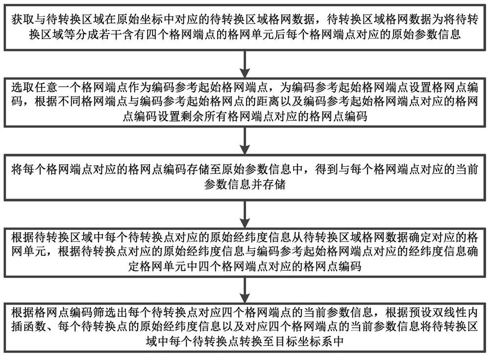
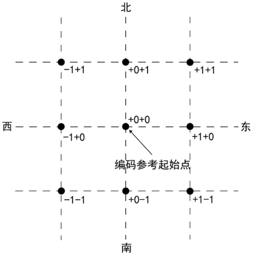
[0036] Below, the present invention will be further described in conjunction with the accompanying drawings and specific implementation methods. It should be noted that, under the premise of not conflicting, the various embodiments described below or the technical features can be combined arbitrarily to form new embodiments. .

[0037] Such as figure 1 As shown, a coordinate transformation method of geographical data in this application, in this embodiment, all points to be converted in the original coordinate system need to be converted into the target coordinate system, the original coordinate system and the target coordinate system in this application The specific object of , can be determined by the user. For example, if the target coordinate system is the 2000 National Geodetic Coordinate System, other coordinate systems that do not belong to the 2000 National Geodetic Coordinate System are recognized as the original coordinate system. The above method specifically inclu...


PUM


Abstract

The invention provides a coordinate conversion method for geographic data. The coordinate conversion method comprises the steps of obtaining grid data of a to-be-converted area, encoding parameters, generating current parameter information, determining grid point codes and performing coordinate conversion. According to the coordinate conversion method of the geographic data, the current parameter information of the four grid endpoints corresponding to each to-be-converted point can be quickly and accurately screened out, so that the efficiency of converting the to-be-converted points from the original coordinate system to the target coordinate system is improved, and the coordinate conversion accuracy is improved.

Description

technical field [0001] The invention relates to the field of geographic data processing, in particular to a coordinate transformation method, equipment, medium and product of geographic data. Background technique [0002] In recent years, the geospatial data of the province's land and resources will update the specifications of the coordinate system from time to time, so that it can display all geospatial data in a unified new coordinate system. The stock data stored in the original coordinate system is transformed into the new coordinate system (ie, the target coordinate system). [0003] In the actual geographic data coordinate conversion work, the most commonly used multi-parameter method is Bursa model conversion, seven-parameter model conversion, four-parameter model conversion, and map frame correction value conversion in the grid method. The accuracy of the correction amount conversion is the highest. However, it is difficult to determine the parameter information o...

Claims


Application Information

Patent Timeline
IPC IPC(8): G06F16/29G06F16/22
Inventor 王斌刘剑周正玉李土旺杨志刚王腾罗亮邱宏华王冬至梁子杰李蕾江夏何少青黎鑫宇
Owner 广东省国土资源测绘院
Why Eureka
Try Eureka