Aerial image building contour extraction method based on machine learning

A technology for aerial imagery and contour extraction, applied in neural learning methods, instruments, image analysis, etc., to achieve the effect of ensuring integrity, more contours, and regular contours

Pending Publication Date: 2022-07-29
NINGBO SHANGHANG SURVEYING & MAPPING
View PDF0 Cites 0 Cited by
  • Summary
  • Abstract
  • Description
  • Claims
  • Application Information

AI Technical Summary

Problems solved by technology

Although the building extraction results based on the fusion of high-resolution remote sensing images and deep neural networks perform well, there is s

Method used


Image

  • Aerial image building contour extraction method based on machine learning
  • Aerial image building contour extraction method based on machine learning
  • Aerial image building contour extraction method based on machine learning

Examples


Embodiment Construction

[0063] Describe the present invention in further detail below in conjunction with accompanying drawing:

[0064] A method for extracting building contours from aerial images based on machine learning, comprising the following steps:

[0065] Step 1: Create a custom resolution aerial image building outline dataset;

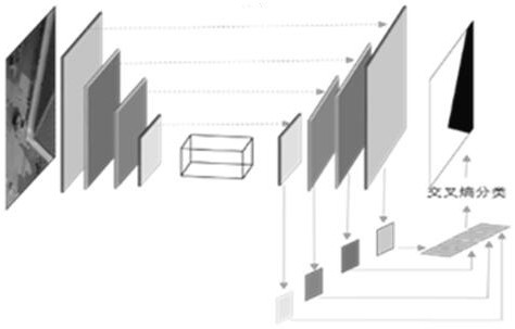
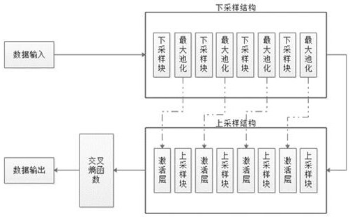
[0066] Step 2: Input the dataset into the Self-net model for training. The Self-net model includes four groups of down-sampling blocks and four groups of up-sampling blocks. The training process includes:

[0067] The data set is input into the up-sampling block to realize the down-sampling of the data. Each group in the down-sampling block is connected through the pooling layer to extract the features of the data, and the data obtained by pooling is used as the data of the next down-sampling block. Input, perform multiple consecutive downsampling on the data; perform upsampling operation on the final output data of the downsampling block, each group in the upsamp...


PUM


Abstract

The invention discloses an aerial image building contour extraction method based on machine learning. The method comprises the steps of 1, making an aerial image building contour data set; 2, inputting the data set into a Self-net model for training, wherein the Self-net model comprises four groups of down-sampling blocks and four groups of up-sampling blocks; 3, verifying an obtained result, calculating a loss value of the model, finally performing comparison calculation with a true value, spreading an error back to the model, continuously updating the model, and performing reciprocating learning; and step 4, the final model carries out convolution classification on the data and outputs the data. According to the method, the data set can be output in a self-defined resolution, the contour is more regular and tidy, and the data set can be fully automatically manufactured compared with other means; the overall effect of the improved model in the data set is better than that of the original model, the initial precision is high under the conditions of the data set and the initialization parameters, and the high training precision can be achieved in a short period.

Description

technical field [0001] The invention relates to the technical field of computer vision three-dimensional image reconstruction, in particular to a method for extracting building outlines from aerial images based on machine learning. Background technique [0002] With the in-depth construction and development of digital cities and smart cities, people's demand for geographic information data is becoming more and more refined, and the update speed is accelerating. No matter from the form of expression or the speed of data production, the traditional production process of geographic information data can no longer meet the needs of the current society. The hardware equipment and technical methods based on new surveying and mapping are constantly being updated, which puts forward higher requirements on the time and accuracy of data production. At present, the oblique photogrammetry software developed based on graphics can only meet the needs of visual viewing, but cannot meet the...

Claims


Application Information

Patent Timeline
IPC IPC(8): G06V20/10G06T7/181G06N3/04G06N3/08G06K9/62
CPCG06T7/181G06N3/084G06T2207/20084G06T2207/20081G06T2207/20116G06N3/048G06N3/045G06F18/24
Inventor 沈立祥王正虎王亚章秦江涛孙佳龙于浩夏天钰王秋雅骆剑波袁淑婷
Owner NINGBO SHANGHANG SURVEYING & MAPPING
Why Eureka
Try Eureka