Indicating directions to destination and intermediate locations in vehicle navigation systems

a technology of vehicle navigation and directions, applied in the field of directional arrows, can solve problems such as navigation system users relying on directional, use of directional arrows, and certain problems

Inactive Publication Date: 2002-09-12
VISTEON GLOBAL TECH INC +1
View PDF0 Cites 31 Cited by
  • Summary
  • Abstract
  • Description
  • Claims
  • Application Information

AI Technical Summary

Benefits of technology

[0007] The present invention provides methods and apparatus for generating directional indicators on vehicle navigation displays. To achieve the foregoing, the present invention provides a directional arrow on a vehicle navigation system display to assist a driver in driving to a destination. In cases where the vehicle is not at a location matching a road segment in a map database of the system, the directional arrow points to a nearest road segment from the map database instead of the destination. This proves to be useful when the vehicle location is in a rural area and the direction to the destination is away from the nearest road segment. In another aspect of the present invention, the display provides a directional arrow to one or more intermediate locations along the route calculated by the system. This can assist drivers who choose to depart from the calculated route to avoid congestion along the route from traffic, construction, or other delays or when the vehicle is traveling on a winding road.

Problems solved by technology

The use of directional arrows has, however, created certain problems.
One problem occurs when using the directional arrow in a non-digitized area.
The problem with the directional arrow in this instance is that it would lead the user further into remote areas and away from the nearest major highway which might be east-west oriented Interstate Highway 80, even if the highway was only a few miles away.
A second problem experienced by vehicle navigation system users relying on directional arrows occurs when the vehicle is traveling along a calculated route in a direction contrary to the directional arrow.
Yet another problem facing the users of vehicle navigation systems and directional arrows occurs when the vehicle, traveling on a route generated by the navigation system, departs from the calculated route and attempts to use the directional arrow to navigate to the destination.
Problems such as traffic congestion, highway construction, and detours might compel a user to depart from the calculated route to avoid traffic.
The problem with this approach is that even though it might be far more efficient to get back onto the calculated route immediately after passing the congestion or bottleneck, the directional arrow may direct the user away from the best point of access to the original route. FIG. 1C illustrates the problems inherent in such a situation.

Method used


Image

  • Indicating directions to destination and intermediate locations in vehicle navigation systems
  • Indicating directions to destination and intermediate locations in vehicle navigation systems
  • Indicating directions to destination and intermediate locations in vehicle navigation systems

Examples


Embodiment Construction

[0022] Reference will now be made in detail to some specific embodiments of the invention. Examples of specific embodiments are illustrated in the accompanying drawings. While the invention will be described in conjunction with these specific embodiments, it will be understood that it is not intended to limit the invention to any particular specific embodiment. On the contrary, it is intended to cover alternatives, modifications, and equivalents as may be included within the spirit and scope of the invention as defined by the appended claims. In the following description, specific details are set forth in order to provide a thorough understanding of the present invention. The present invention may be practiced without some or all of these specific details. In other instances, well known process operations have not been described in detail in order not to unnecessarily obscure the present invention.

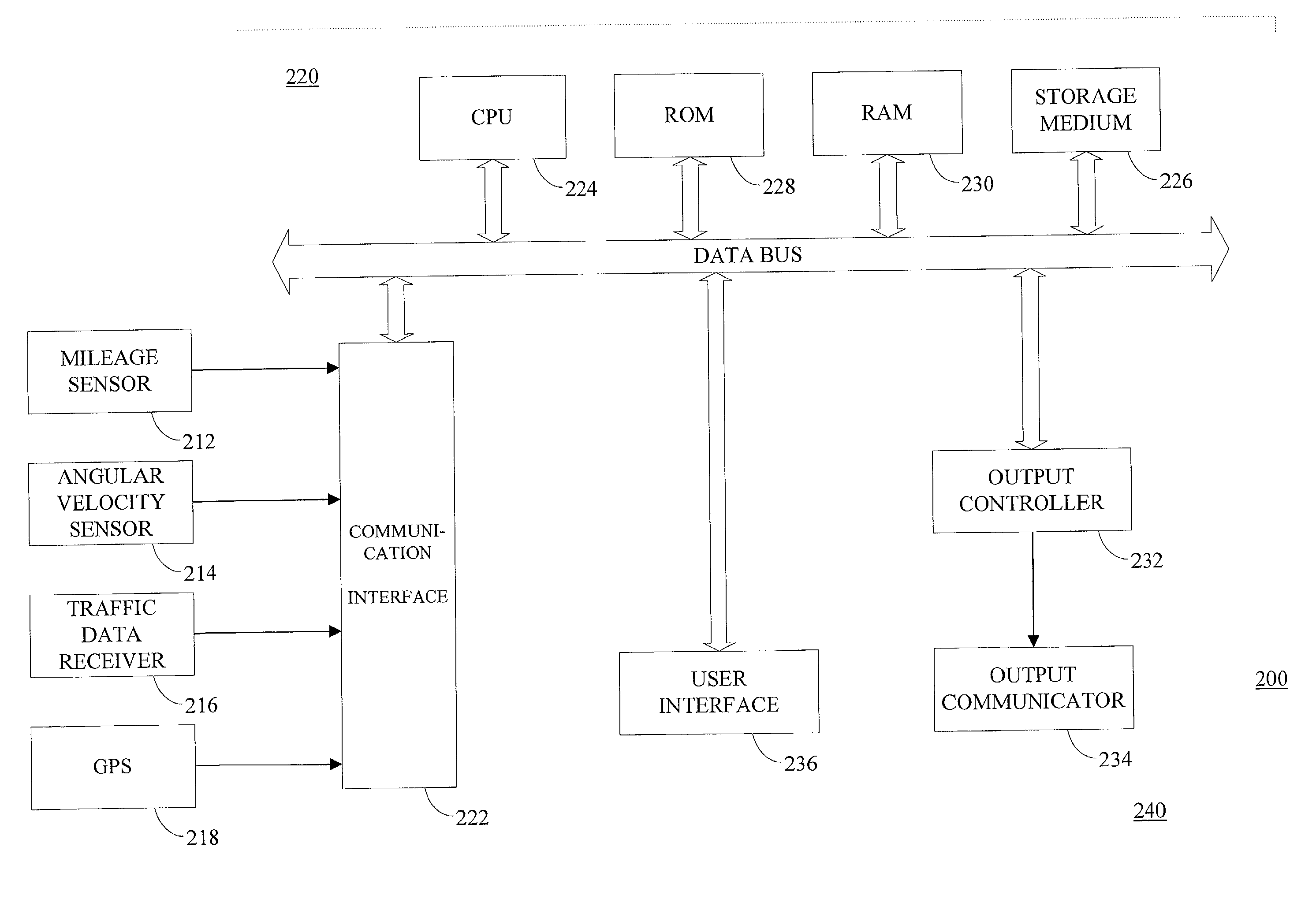
[0023] FIG. 2 is a block diagram of a specific embodiment of a vehicle navigation syst...


PUM


Abstract

The present invention provides a computer implemented method and apparatus for providing a directional arrow to intermediate locations to aid a user of a vehicle navigation system. According to one aspect of the present invention, a vehicle navigation system is provided and includes a processor configured to determiner the vehicle location from location data generated by a plurality of sensors. Where the location data does not correspond to map data in a map database, a directional indicator is generated on the display to indicate a first location corresponding to the map data. In one embodiment, the first location corresponds to a road segment in the map database nearest the vehicle location. In another embodiment, the processor is configured to identify an intermediate location on the route and generate a directional indicator on the display which indicates the direction to the intermediate location. In yet another embodiment, the processor is configured to automatically select an appropriate intermediate location in accordance with the measured angle between the vehicle heading and the intermediate location.

Description

BACKGROUND OF THE INVENTION[0001] The present invention relates to vehicle navigation systems. More specifically, the invention relates to the use of directional arrows displayed on vehicle navigation systems and associated with directions of travel to destinations.[0002] Vehicle navigation systems have become more prevalent in recent times. Typically vehicle navigation systems employ a map database wherein information such as digitized road segments, points of interest, landmarks, and similar location data is stored. Some vehicle navigation systems use Global Positioning Sensors to determine the vehicle's location and compare the sensor data with the stored digitized map data. The degree to which road information is digitized varies considerably in different geographical areas. For instance, in a sparsely populated state or region, only roads of a high level in the road hierarchy might be digitized and stored in a map database. Densely populated regions, such as portions of the Sta...

Claims


Application Information

Patent Timeline
Patent Type & Authority Applications(United States)
IPC IPC(8): G01C21/34
CPCG01C21/3415
Inventor POLIDI, ARI I.ZUBER, GARY
Owner VISTEON GLOBAL TECH INC
Why Eureka
Try Eureka