Geocoding method using multidimensional vector spaces

a vector space and geocoding technology, applied in pulse techniques, instruments, computing models, etc., can solve the problems of inability to work well, current geocoding technology only examines the zip code field, and current geocoding technology is considered to be imprecis

Inactive Publication Date: 2006-11-02
AMERICAN TELEPHONE & TELEGRAPH CO
View PDF6 Cites 37 Cited by
  • Summary
  • Abstract
  • Description
  • Claims
  • Application Information

AI Technical Summary

Problems solved by technology

One of the disadvantages of ZIP code matching alone is that current geocoding technology only examines the ZIP code field when matching.
Current geocoding technology is considered to be imprecise, and only works well when the input is a well-formed and existing street address and the desired output is a physical point location.

Method used


Image

  • Geocoding method using multidimensional vector spaces
  • Geocoding method using multidimensional vector spaces
  • Geocoding method using multidimensional vector spaces

Examples


Embodiment Construction

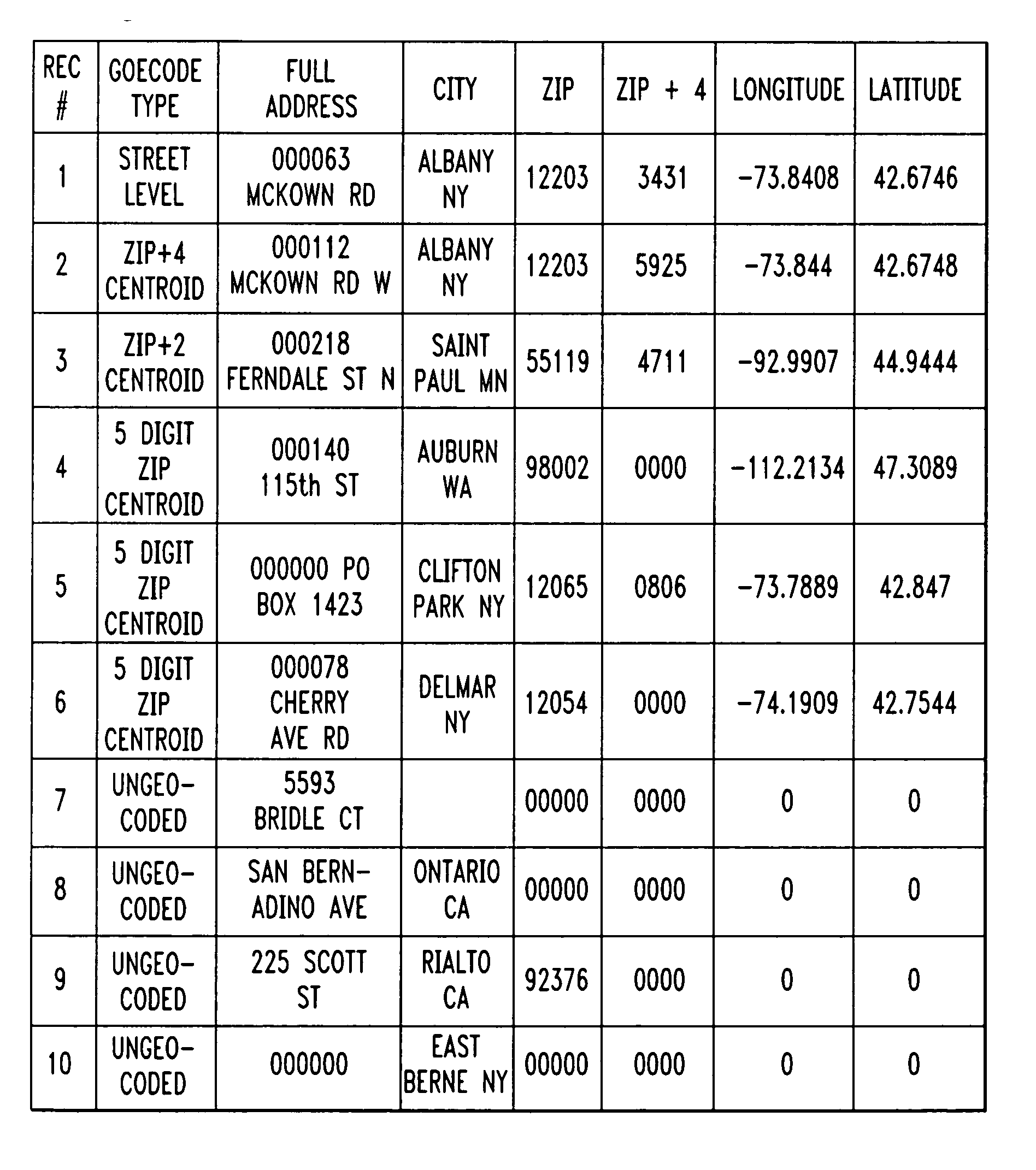
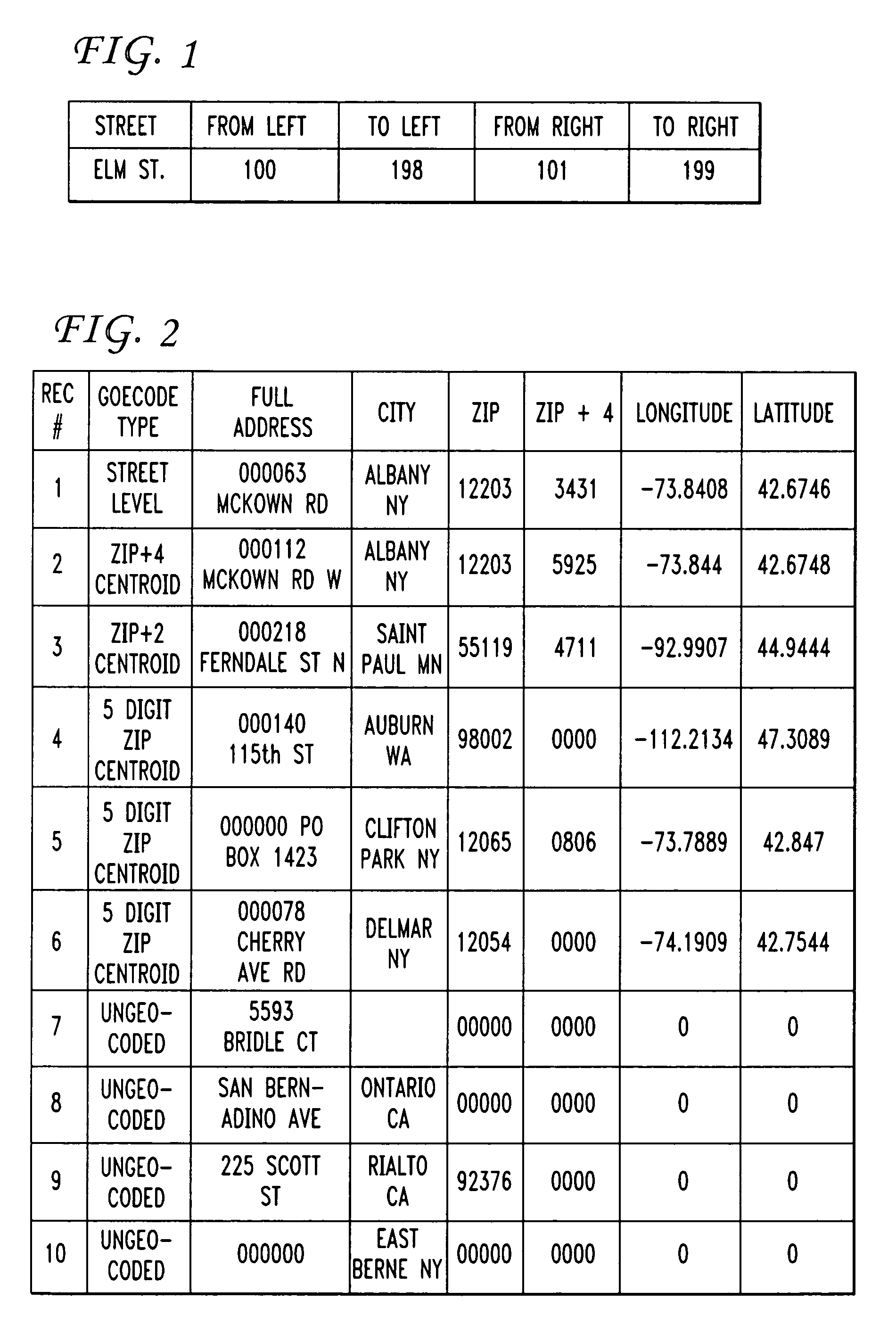
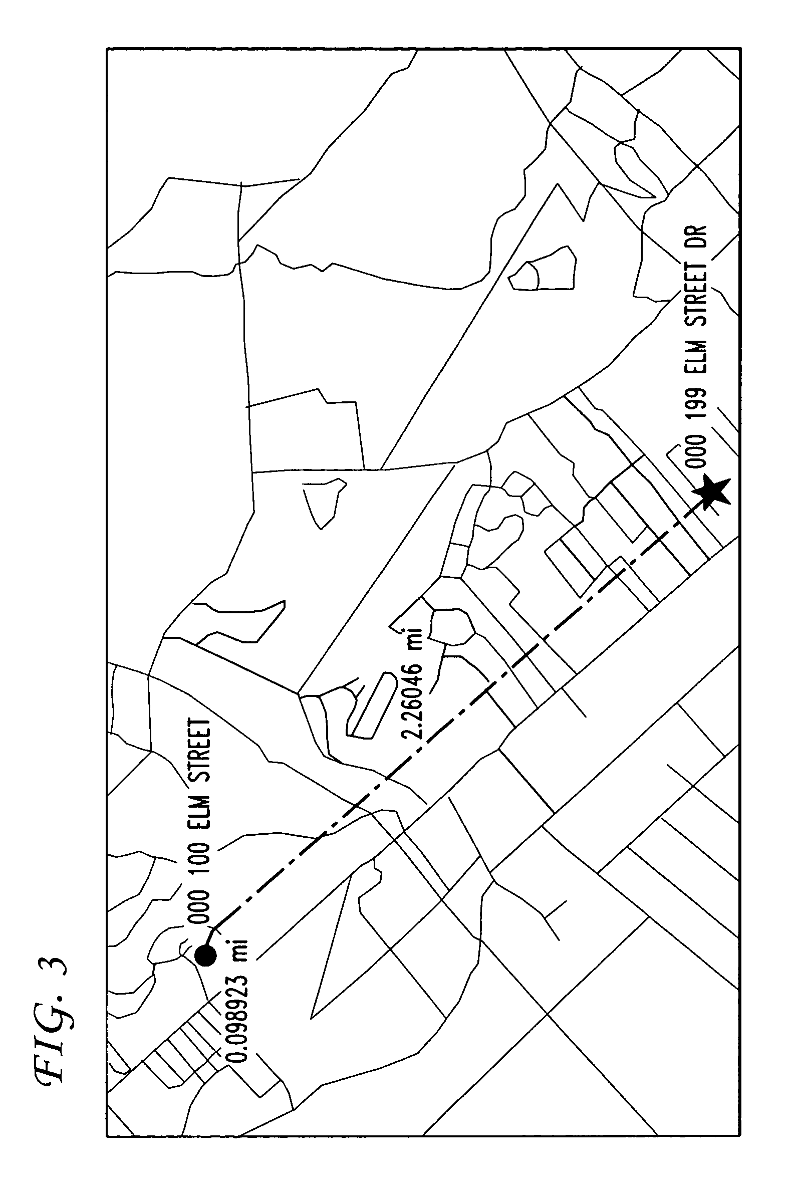
[0018] A vector is defined as a geometric element possessing both length and direction. A “characteristic vector”, for the purposes of the present invention, is defined as a “locate” match result that is a measure of both the reliability of the match and the tests used to find the match. The characteristic vector, by itself, does not indicate anything about the actual physical location of a match.

[0019] Simple geocoding involves a single test (or set of dependent tests) that is used to generate a single result (the most likely match). In accordance with the teachings of the present invention, multiple tests and multiple data inputs are used to generate a plurality of characteristic vectors, where vector mathematical properties are then exploited to convert imprecise point location results into precise bounding geometries.

[0020] Consider a series of tests t0, t1, . . . , tn and their associated results for a specific point, expressed as “uncertainty” factors u0, u1, . . . , un. Var...


PUM


Abstract

A process for evaluating and geocoding of GIS data elements utilizes a plurality of “locate” tests and a weighting scheme to express the match results as a multidimensional vector. Multiple inputs and data sources, as well as ambiguous and partial input data, are used to generate an output with improved precision by applying a weighting function to each input element and generating a set of test vectors (i.e., the input data element weighted by the known accuracy of the element / source). A sum of a plurality of tests is then generated as the “characteristic vector” of the test set. By using two (or more) different sets of test, two (or more) characteristic vectors are formed. Various well-known algebraic techniques can then be used to evaluate the results of each set of tests and select the “best match” result.

Description

CROSS-REFERENCE TO RELATED APPLICATION [0001] The present application claims the benefit of U.S. Provisional Application No. 60 / 649,286, filed Feb. 2, 2005.TECHNICAL FIELD [0002] The present invention relates to a process for the evaluation and geocoding of geographic information systems (GIS) data elements and, more particularly, to a process that uses multiple “locate” tests and a weighting scheme to express the search results as a multidimensional vector. BACKGROUND OF THE INVENTION [0003] Geocoding is generally thought of as the act, method, or process of programmatically assigning x and y coordinates (usually, but not limited to, latitude and longitude) to records, lists and files containing location information (full addresses, partial addresses, zip codes, census FIPS codes, etc.) for cartographic or any other form of spatial analysis or reference. Currently, geocoding is- used to convert a street address or other textually-specific geographic location information into a phys...

Claims


Application Information

Patent Timeline
Patent Type & Authority Applications(United States)
IPC IPC(8): H04M7/00
CPCG06F17/30241G06F16/29
Inventor ASHER, MICHAELGIDDENS, CHARLESESLAMBOLCHI, HOSSEINSTEWART, HAROLD J.
Owner AMERICAN TELEPHONE & TELEGRAPH CO
Why Eureka
Try Eureka