GPS explorer

a technology of gps and explorer, which is applied in the direction of navigation instruments, electric signalling details, instruments, etc., can solve the problems of difficult to find relevant data when it is needed, difficult to find out, and few people have the time, motivation or patience to search

Inactive Publication Date: 2007-01-04
TAYLOR WILLIAM MICHAEL FREDERICK
View PDF56 Cites 125 Cited by
  • Summary
  • Abstract
  • Description
  • Claims
  • Application Information

AI Technical Summary

Benefits of technology

[0014] The system can provide GPS positioned simulations using virtual reality displays. The GPS derived position, elevation, viewing direction and time of day, enables simulated structures, buildings, dams, roads and landscape features to be dropped into the users field of view and to be examined from all angles around the proposed site while it is still virgin territory.
[0017] The device has an audible menu system which when used with voice command, enables the device to be used hands free and eyes free. Feedback protection avoids the audio output triggering the voice input system.

Problems solved by technology

However, we all have different needs and interests, some need commercial information, others may wish to buy a product, some people like to know the history of a place, or to discover hidden corners, others are simply bored and long for their journey to be made more interesting.
As databases grow in size so the problem of finding relevant data when it is needed becomes more difficult to solve.
Few people have the time, motivation or patience to search through telephone books, yellow pages, guide books, information systems and the like.
Even when at home it can be difficult to find out what is happening in the area today which might be of interest.
When walking, driving, sailing or flying our need for information remains, although our ability to search for it may be severely limited by the task in hand.
Most portable GPS receivers on the market today are designed for navigation, giving the user's position in terms of latitude and longitude or bearing and distance from a known point, both methods are cumbersome to use.
Although GPS moving map displays show positions more clearly, their applications remain rather limited, due to the need for a screen and the risk of distraction when walking or driving.
Talking books using CD-ROM disks may provide the information lacking in the above mentioned navigation systems, however as the location of the user is not monitored automatically, any information must be extracted manually by the user, which can be laborious.
It is not easy to use such a portable PC when walking or riding on horseback.

Method used


Image

  • GPS explorer
  • GPS explorer
  • GPS explorer

Examples


Embodiment Construction

[0024] An audio only version of the design will now be described by reference to the accompanying drawings.

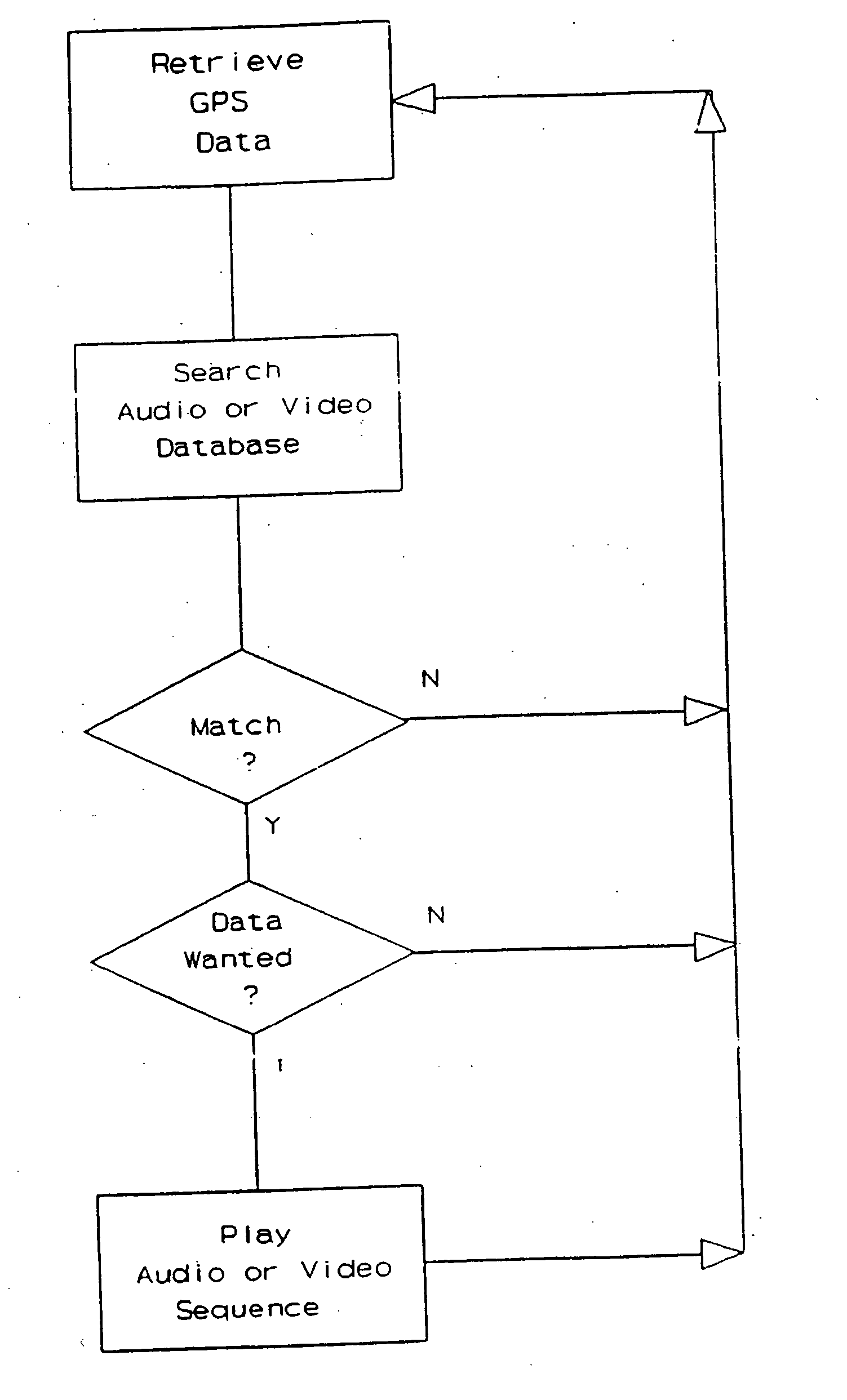
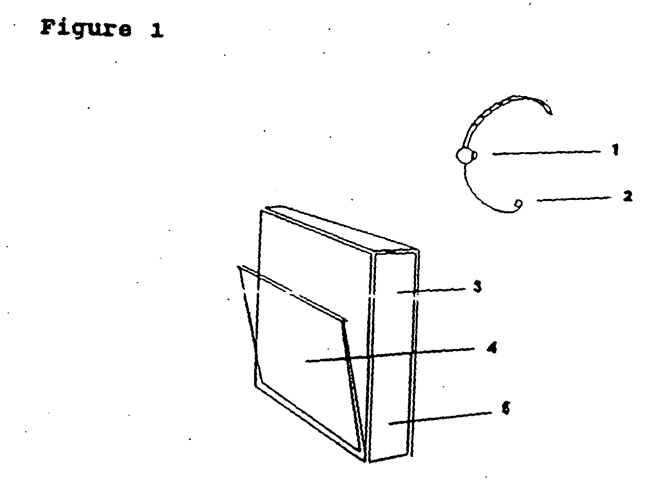
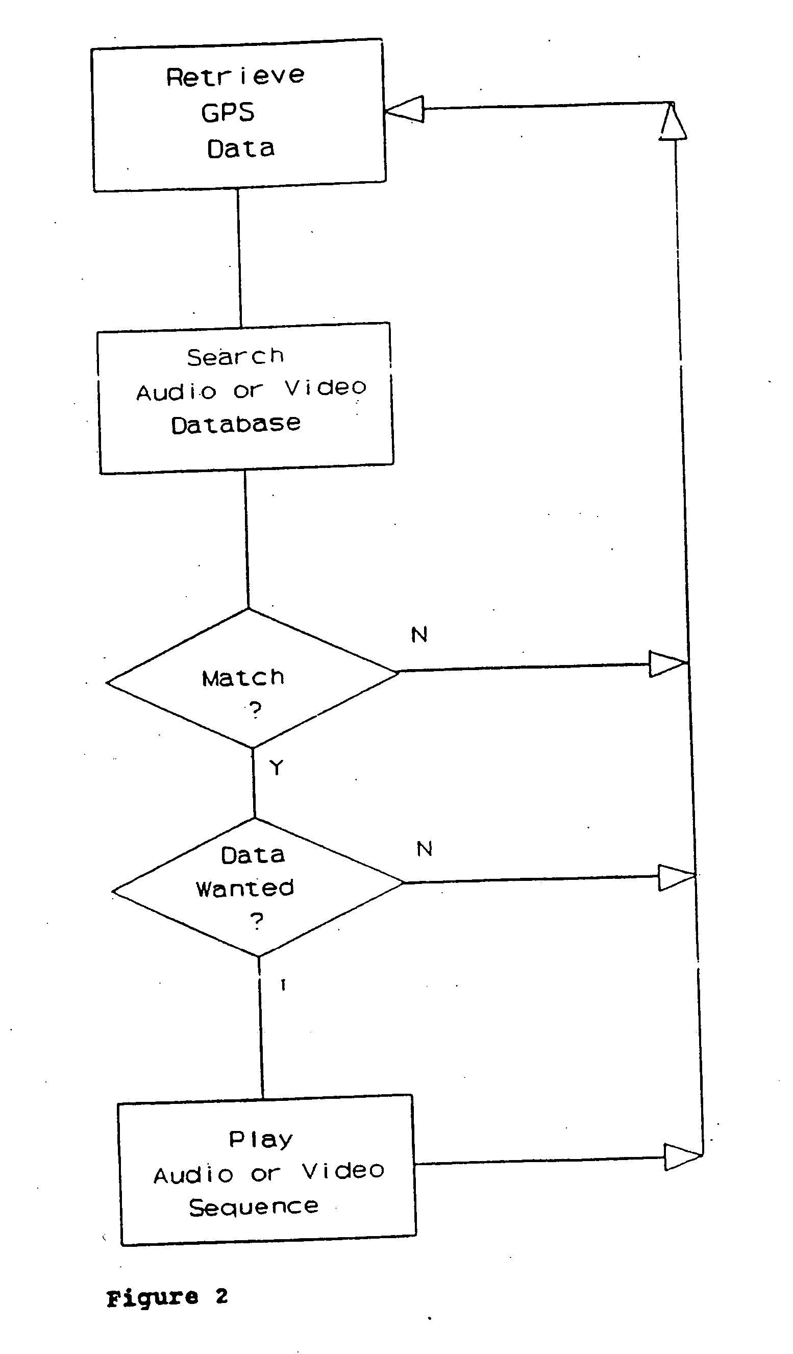
[0025]FIG. 1 shows the audio only version of the device comprising: audio earpiece 1, microphone 2, the GPS receiver 3, the CD drive 4 and the processor 5. FIG. 2 shows the basic logic used to monitor the user's position and to retrieve and play the appropriate audio. FIG. 3 shows a map on which large dots represent the positions determined by GPS at which specific audio phrases will be selected from the database or radio broadcast and played. Samples of typical audio phrases are numbered 1-6.

[0026] The GPS latitude / longitude co-ordinates of places of interest such as historic buildings, castles, villages, parks, lakes, mountains, panoramic viewpoints and so forth may be digitized from maps or by on site survey. Audio describing each place of interest will then be recorded and stored, in compressed form, with corresponding GPS co-ordinates, in a database on a compact disc (GP...


PUM


Abstract

This is a portable information system which uses Global Positioning System (GPS) data as a key to automatically retrieve audiovisual data from a database. On a journey the system can automatically identify and describe places of specific interest to the user, landmarks and the history of nearby buildings, or locate hotels, hospitals, shops and products within a radius of the present position. Audible menus and voice command give hands-free and eyes-free control while driving, flying, sailing or walking.

Description

TECHNICAL FIELD [0001] The invention is a portable information system which uses Global Positioning System (GPS) data as a key to retrieve audio visual information from a database or broadcast. BACKGROUND TO THE INVENTION [0002] Almost everyone who travels needs information about the place they are visiting. However, we all have different needs and interests, some need commercial information, others may wish to buy a product, some people like to know the history of a place, or to discover hidden corners, others are simply bored and long for their journey to be made more interesting. [0003] As databases grow in size so the problem of finding relevant data when it is needed becomes more difficult to solve. Few people have the time, motivation or patience to search through telephone books, yellow pages, guide books, information systems and the like. Having taken a long trip it is often only on returning home when one learns too late what has been missed. Even when at home it can be dif...

Claims


Application Information

Patent Timeline
Patent Type & Authority Applications(United States)
IPC IPC(8): G01S5/14H04Q7/20G08B1/08G08G1/123G01S19/25
CPCG01C21/00G08G1/0962G06Q30/00
Inventor TAYLOR, WILLIAM MICHAEL FREDERICK
Owner TAYLOR WILLIAM MICHAEL FREDERICK
Why Eureka
Try Eureka