Method and apparatus for indexing, storing and retrieving raster (GRID) data in a combined raster vector system

a combined raster vector and data technology, applied in the field of indexing, storing and retrieving raster and vector data, can solve the problems of large volume of such data, tight processor performance restrictions, and particularly troublesome hardware restrictions of this natur

Inactive Publication Date: 2007-11-01
MAPINFO
View PDF13 Cites 45 Cited by
  • Summary
  • Abstract
  • Description
  • Claims
  • Application Information

AI Technical Summary

Problems solved by technology

Due to cost considerations, many of these products have tight restrictions on processor performance, and on available on-board memory for mass database storage.
Hardware restrictions of this nature are particularly troublesome for portable products, such as global positioning devices, involving embedded systems, because such systems require access to spatial (e.g., geographic / cartographic) data for mapping or navigation purposes.
The volume of such data is quite large, and the available memory is limited by cost and physical size considerations.

Method used


Image

  • Method and apparatus for indexing, storing and retrieving raster (GRID) data in a combined raster vector system
  • Method and apparatus for indexing, storing and retrieving raster (GRID) data in a combined raster vector system
  • Method and apparatus for indexing, storing and retrieving raster (GRID) data in a combined raster vector system

Examples


Embodiment Construction

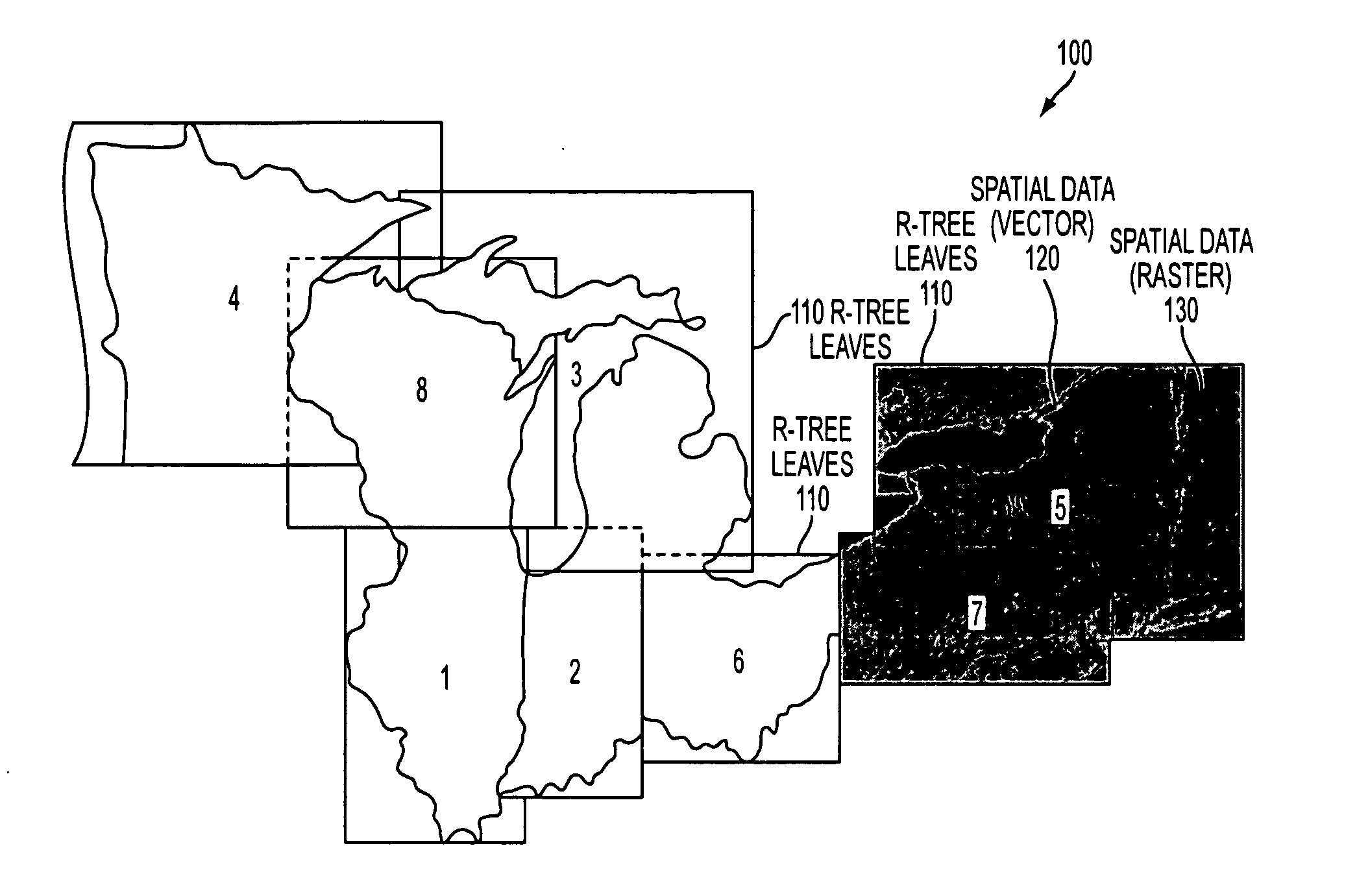
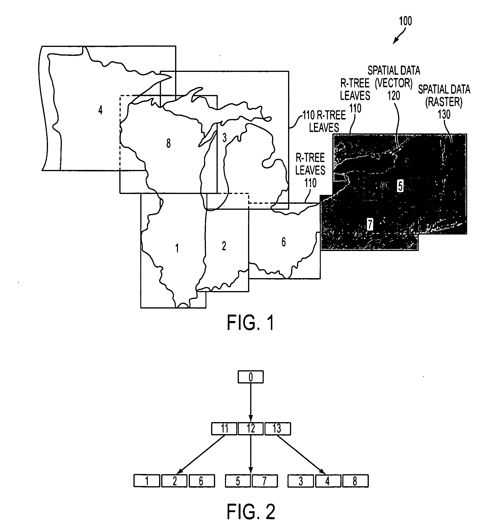
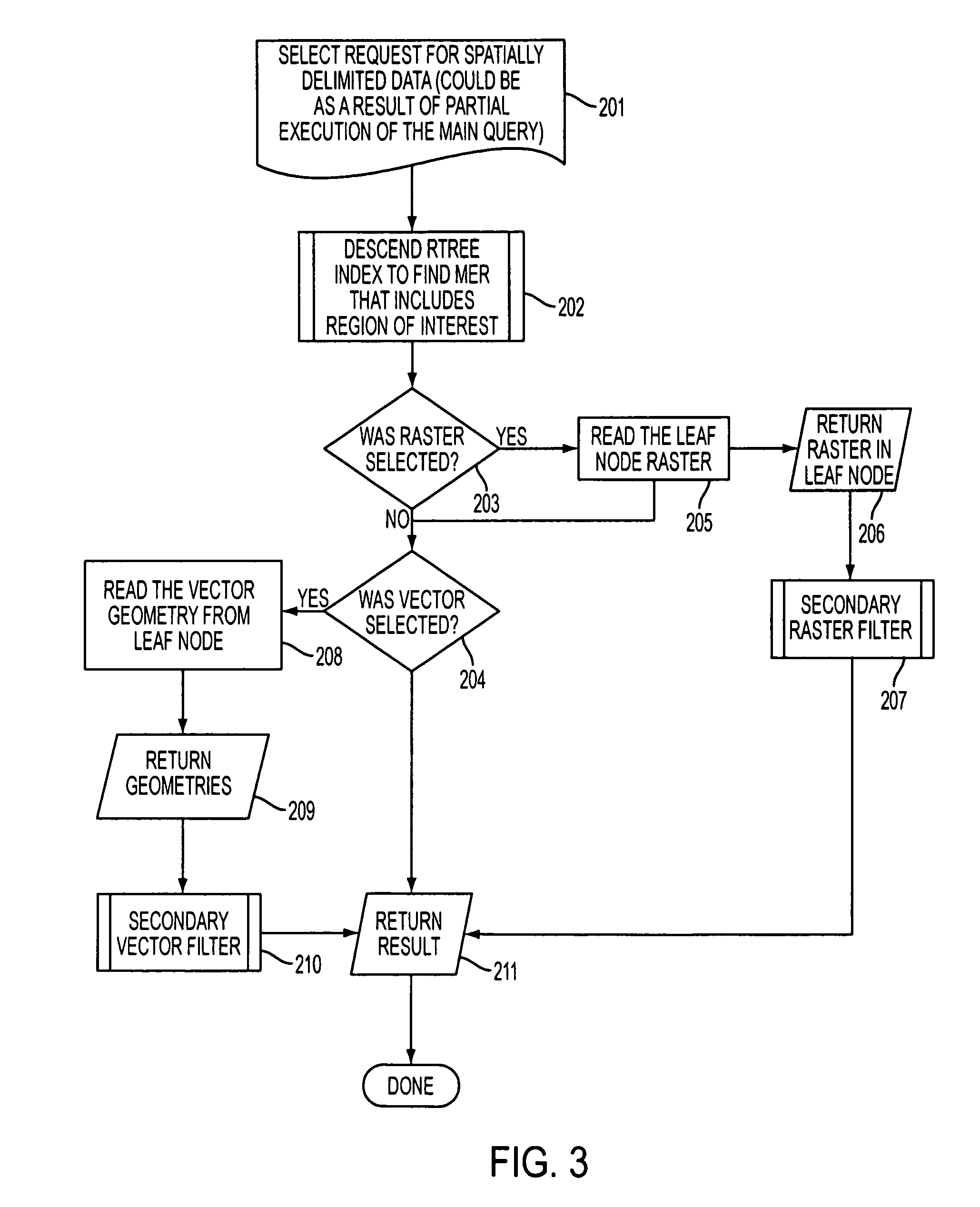
[0021] The invention proposes that the R-trees (or its variants, such as R*trees) for the vector data be reused as a mechanism for query and retrieval of raster data in conjunction with or instead of the vector data.

[0022] Typically, in the prior art, the vector feature would first be retrieved or queried and then a buffer created. The imagery would be requested and the buffer would then be used to clip the imagery, and finally the image footprint and the attribution would be joined. When the image and vector data exist in the same leaf of the index, the raster data can readily be cut with the vector representation (e.g., the buffer) within the single query and with only one index lookup.

[0023]FIG. 1 is an illustration of a simplified R-Tree constructed in accordance with the invention. FIG. 2 illustrates the hierarchal flow chart of the layering effect of the R-tree structure 100 of FIG. 1. Referring to FIGS. 1 and 2, the invention uses the Minimum Enclosing Rectangle (MER) of th...


PUM


Abstract

The invention relates to a method and apparatus that uses an R-tree's vector data as a mechanism for query and retrieval of raster data in conjunction with or instead of the vector data. The invention relates to a method of storing, indexing and retrieving raster data comprising: storing raster data, storing vector data, and indexing said raster data and said vector data with same index information.

Description

FIELD OF THE INVENTION [0001] The invention relates generally to indexing, storing and retrieving raster and vector data together in a database to enhance performance and achieve operational efficiency. BACKGROUND OF THE INVENTION [0002] Many electronic products, such as mapping systems, GIS's, computer aided design systems, and global positioning systems, require database storage of spatial data. In particular, they need to store raster and vector data and be able to query and retrieve arbitrary combinations of these data types. Due to cost considerations, many of these products have tight restrictions on processor performance, and on available on-board memory for mass database storage. Hardware restrictions of this nature are particularly troublesome for portable products, such as global positioning devices, involving embedded systems, because such systems require access to spatial (e.g., geographic / cartographic) data for mapping or navigation purposes. The volume of such data is ...

Claims


Application Information

Patent Timeline
Patent Type & Authority Applications(United States)
IPC IPC(8): G06K9/54G06K9/48G06F17/30
CPCG06F17/30961G06F17/30241G06F16/29G06F16/9027
Inventor BERRILL, ARTHUR R.KANNAN, ANAND
Owner MAPINFO
Why Eureka
Try Eureka