
Method For Adding Characterization Data During an Image Capture

Inactive Publication Date: 2008-06-12
EASTMAN KODAK CO
View PDF3 Cites 32 Cited by
  • Summary
  • Abstract
  • Description
  • Claims
  • Application Information

AI Technical Summary

Benefits of technology

[0007]Compared with the prior art, the object of the present invention is to enable a user of a mobile terminal comprising a digital image capture means and also comprising other means for linking and saving digital data, to manage, in a fast, user-friendly and personal or private way, the data or information linked to these images, such as for example image geolocalization data. The management of these data includes in particular the addition of new data specific to an image, and the fact of being able to easily and quickly find images using data characterizing for example an event or a geographic location (geolocalization) linked to these images.
[0011]In an advantageous embodiment of the invention, during the capture of several images located in the same cell area, these image captures preferably being performed within a short period of time, for example a few minutes, the method also enables all the cells linked to each of the captured images to be grouped, and the same characterization identifier of the geographic location of capture to be linked to it.
[0012]In an advantageous embodiment optimizing the invention, the method also enables, during an image recording, the ID of the cell of the geographic location of the image capture to be automatically compared with all the IDs saved in the mobile terminal. Then, based on this comparison operation, the program enables the ID of the cell of the geographic location of image capture to be automatically linked with the characterization identifier linked to the capture of the corresponding image, if the pair formed by said ID of the cell containing the geographic location of the image capture and said linked characterization identifier is already saved in the recording means. In other words, the method enables the step of manually entering the characterization identifier linked to the image capture to be avoided, provided it was already entered by the user during a previous image capture performed in the same geographic location. This means that over time, the user has less and less manual entering to carry out, because there are more and more IDs of cells containing the geographic locations where the images were captured that are saved in the mobile terminal and linked with the corresponding characterization identifiers to form identifier pairs. Statistically, there is a fairly high probability that over time the user of the terminal will repeat image captures in locations where he / she has already taken one in the past.
[0013]In another advantageous embodiment optimizing the invention, the method also enables, during an image capture from a first terminal, the automatic detection of at least one second mobile terminal, located in an environment close to the geographic location of image capture, and then the automatic sending, from the first terminal, of a request to the at least one second nearby terminal. This request enables the ID of the cell containing the geographic location of image capture to be automatically compared with the IDs saved in the second nearby terminal, and depending on the ID pairs saved in the second terminal, the ID of the cell containing the geographic location of image capture to be automatically linked to a characterization ID linked to the capture of said image. This characterization identifier is returned (in response to the request) to the first terminal; this characterization identifier linked to the image capture was already saved in one of these other nearby second terminals. The method then enables the automatic saving of the identifier pair in the first terminal having performed the image capture.

Problems solved by technology

The implementation of geolocalization techniques, for example of the LBST type (Location Based Services Technology) in a communication environment comprising mobile terminals or platforms of the phonecam type, can be technically fairly complex and daunting for the phonecam user.
The GPS system (Global Positioning System) enables a precise location to be obtained, but requires the mobile terminal to be equipped with a GPS module, which represents high cost and high energy consumption.
Furthermore, geolocalization by this GPS technique works poorly in enclosed places (buildings).
A problem common to both the GPS and EOTD systems is the relating of the geolocalization data (X, Y) to data characterizing the geographic locations that have a meaning for the user (e.g. “at home”, “Peter's house”, etc.).

Method used


Image

  • Method For Adding Characterization Data During an Image Capture
  • Method For Adding Characterization Data During an Image Capture

Examples


Embodiment Construction

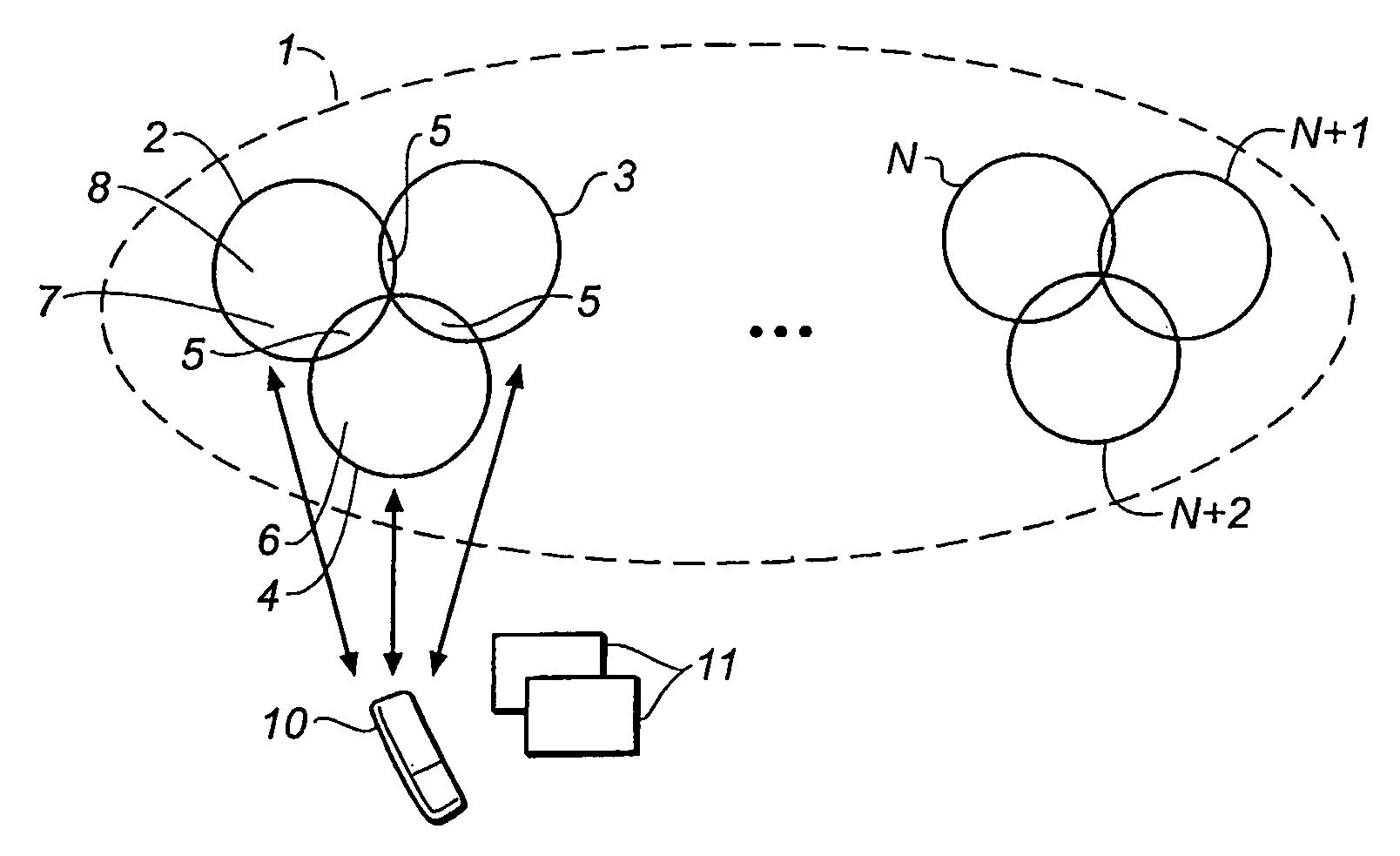
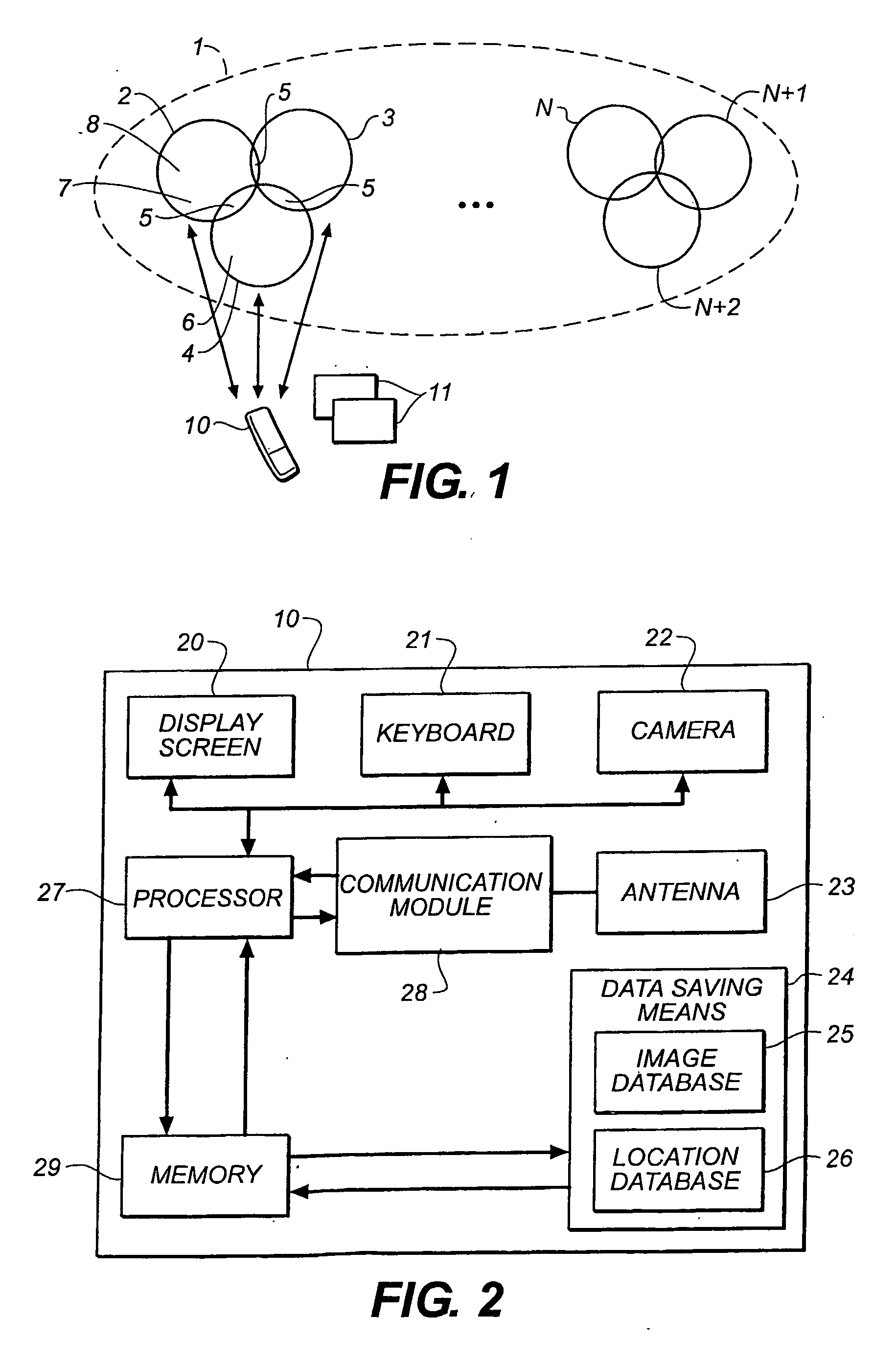
[0018]The following description is a detailed description of the main embodiments of the invention, with reference to the drawings in which the same numerical references identify the same elements in each of the different figures.

[0019]FIG. 1 shows a cellular radiocommunication network 1. This network 1 has (N+1) cells, referenced from 2 to N+2 (or 2-N+2). Each cell contains a communication tower or radio relay. These towers enable a first mobile terminal 10 to communicate, for example with a second terminal of the same type (not shown on the figures) operating in the same network. The second terminal is for example a cellphone. Two neighboring cells 2, 3, 4 have a common area 5 where the signal emitted by each of the cells is sufficiently powerful, i.e. greater than a minimum power enabling reliable communication between the terminal 10 and the tower of each of the cells 2, 3, 4. The surface area of the common area 5 is generally relatively small compared with the total surface are...


PUM


Abstract

The invention is in the field of digital imaging. The invention relates more specifically to a method for automatically adding and finding characterization data linked to images. The method is implemented in a cellular communications network (1). The method according to the invention is used in a cellular communications network (1), and enables fast, user-friendly and private, management of image characterization data, such as their geolocalization. The invention method comprises the following steps: a) automatically saving, in a mobile terminal (10) comprising a digital image capture means and other digital data linking and saving means capable of communicating with the image capture means, the cell ID (2-N+2) of the network (1) which contains the geographic location (6, 7&8) where the capture of at least one image (11) was performed using the mobile terminal (10); b) automatically linking the cell ID containing the geographic location of the image capture (11) with a characterization identifier linked to the image capture entered from the terminal (10), to form a pair of these IDs; c) automatically saving, in the mobile terminal (I O), the ID pair formed in step b).

Description

FIELD OF THE INVENTION[0001]The invention is in the field of digital imaging. The invention relates more specifically to a method for adding characterization data during an image recording. The method is implemented in a cellular telecommunications network.BACKGROUND OF THE INVENTION[0002]The use of communication platforms including radio-controlled telecommunication means and digital image capture and saving means is multiplying. The encouragement to use these platforms to exploit them to the maximum, in a fast and user-friendly way is thus strong. This encouragement is further increased, due to the constant improvement of the memory and display capacities of these platforms.[0003]These platforms or mobile terminals include at the same time telecommunication means, for example telephony, and images capture and saving means. A commonly-used type of digital platform is called a phonecam. A phonecam is a mobile terminal having both a cellular phone function and a video or digital came...

Claims


Application Information

Patent Timeline
IPC IPC(8): H04N1/21H04M1/00
CPCH04N1/00307H04N2201/3253H04N1/21
Inventor VAU, JEAN-MARIETOUCHARD, NICOLAS P.FURON, OLIVER A.
Owner EASTMAN KODAK CO
Learn More