
Efficient integration of road maps

Inactive Publication Date: 2008-10-16
UNIVERSITY OF TORONTO +2
View PDF8 Cites 11 Cited by
  • Summary
  • Abstract
  • Description
  • Claims
  • Application Information

AI Technical Summary

Benefits of technology

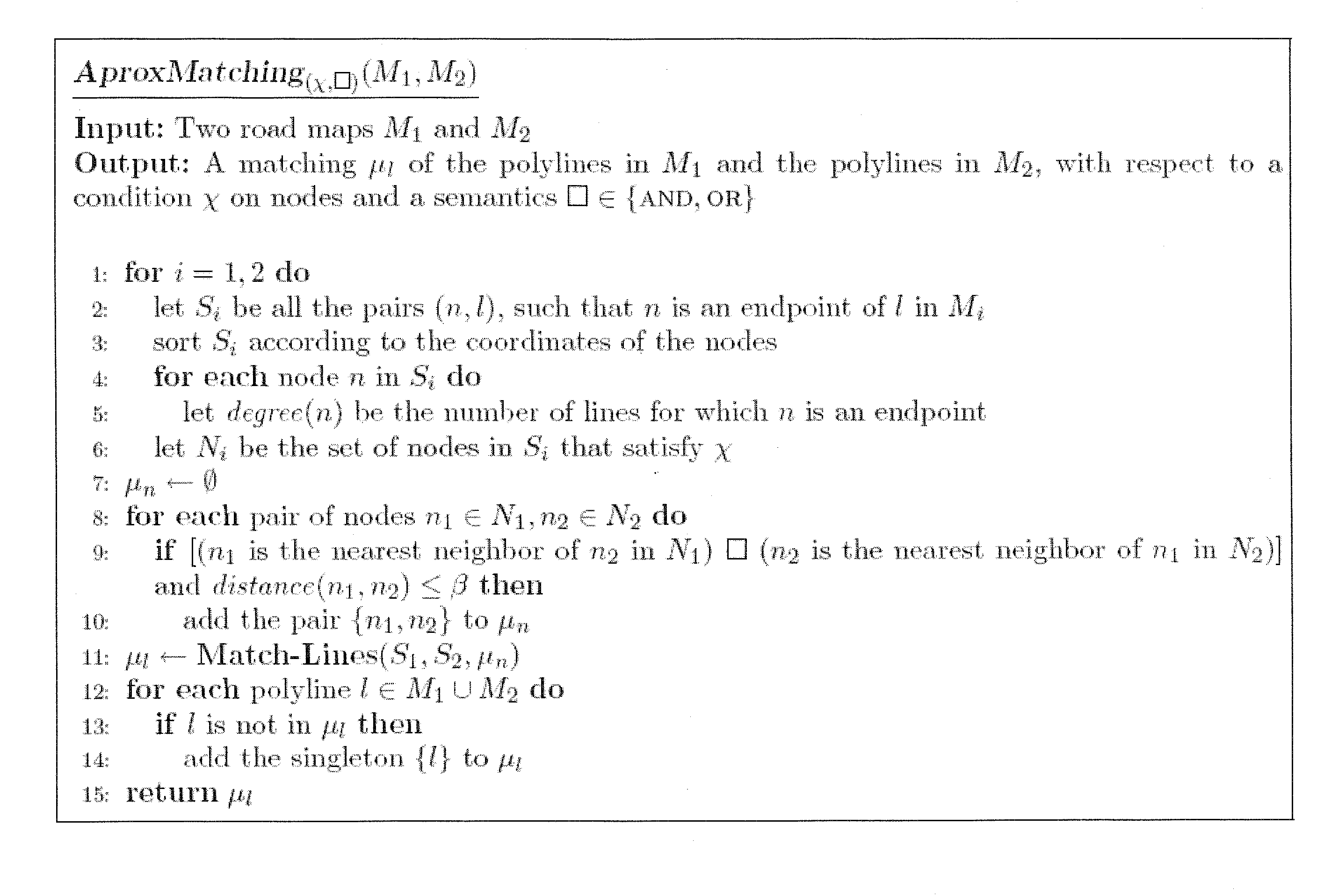
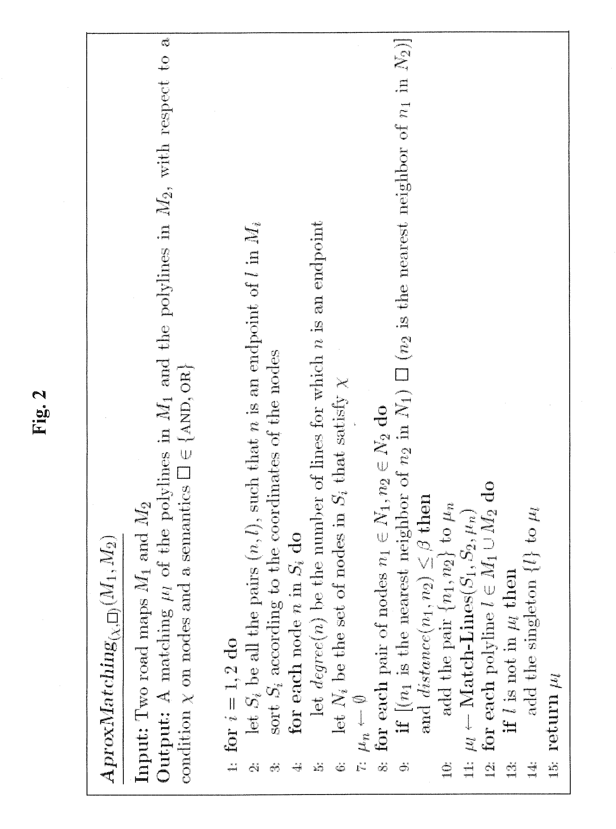
[0007]The present invention relates to maps in which roads are represented by polygonal lines (polylines). An integration of two such maps is essentially a matching between pairs of polylines that represent the same road in the two maps. The novelty of the invention is in matching roads based merely on locations of endpoints of polylines rather than trying to match whole lines. There are two important advantages to our approach. First, integration can be done efficiently. Secondly, we want our techniques to be general in the sense that they would not require the existence of any particular property of roads, other than endpoint locations. Differently from other properties, location always exists for objects in spatial databases. Also, locations have the same semantics in different maps, so we can compare them without worrying that we will end up comparing unrelated properties. In particular, we do not even use the topology of the road network. This is because using the topology may increase the complexity of the computation. Furthermore, using the topology can be problematic when information is incomplete. For example, we may need to match an intersection of three roads in one map with an intersection of four roads in a second map, due to the fact that some roads are represented in only one of the maps.
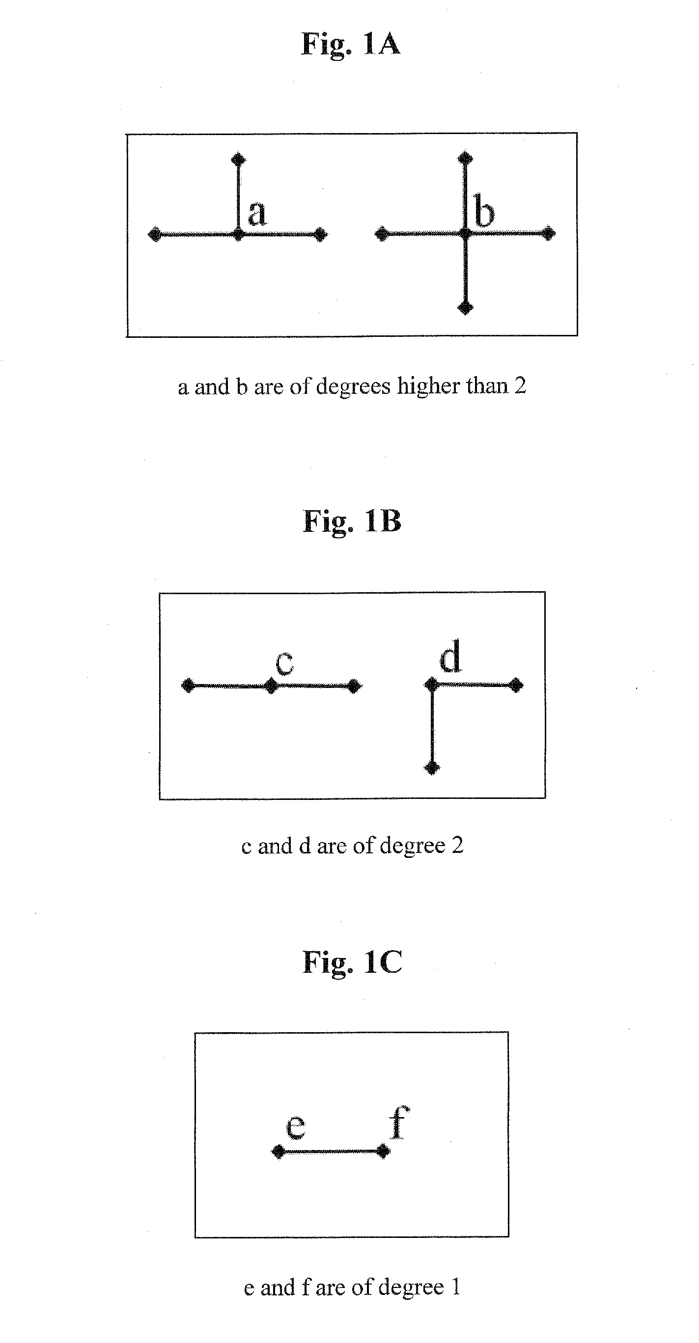
[0011]In order to show the efficiency and the effectiveness of our techniques, we conducted experiments on real-world data. In the tests, we compared the AND and the OR semantics. Also, we investigated the effect of computing the matching using only endpoints that satisfy a given condition about the number of roads that intersect them. Our tests show that the proposed integration methods are efficient and accurate, i.e., they provide high recall and high precision. The tests also show that the best performance, in terms of both efficiency and accuracy, is for the AND semantics when using only endpoints that are intersections of three or more roads.

Problems solved by technology

This is because using the topology may increase the complexity of the computation.
Furthermore, using the topology can be problematic when information is incomplete.
However, this is not the case for the following reasons.
First, locations are not accurate, so usually two maps represent the same real-world entity in two different locations.
Third, information might be incomplete so that a road or a segment of a road, in one map, may not appear in the other map, and vice versa.

Method used


Image

  • Efficient integration of road maps
  • Efficient integration of road maps
  • Efficient integration of road maps

Examples


Embodiment Construction

[0062]In the following detailed description of various embodiments, reference is made to the accompanying drawings that form a part thereof, and in which are shown by way of illustration specific embodiments in which the invention may be practiced. It is understood that other embodiments may be utilized and structural changes may be made without departing from the scope of the present invention.

2. Framework

[0063]In this section we present our framework. We provide formal definitions to the notion of a road map in a geo-spatial database. Also, we discuss the notation of a matching algorithm and we describe the result of such an algorithm.

2.1 Road Map

[0064]A road map represents a network of real-world roads, using nodes and edges. The nodes (also called topological nodes) are either intersections, where two or more roads meet, or road ends where roads terminate without intersecting another road. The edges are road objects. Note that under this interpretation, a road may start or end a...


PUM


Abstract

Systems and methods for integrating maps in which roads are represented as polylines. The main novelty of the invention is in using only the locations of the endpoints of the polylines rather than trying to match whole lines. Experiments on real-world data are given, showing that this approach of integration based on matching merely endpoints is efficient and accurate (that is, it provides high recall and precision).

Description

CROSS-REFERENCE TO RELATED APPLICATIONS[0001]The present application is a continuation-in-part of International Application No. PCT / IL2007 / 001376, filed Nov. 8, 2007, in which the United States is designated, and claims benefit from the Provisional Application No. 60 / 857,805, filed Nov. 9, 2006, the entire contents of each and all these applications being hereby incorporated by reference herein in their entirety as if fully disclosed herein.FIELD OF THE INVENTION[0002]The present invention relates to systems and methods for integrating a plurality of road maps and in particular to integration of digital road maps in which roads are represented as polylines.BACKGROUND OF THE INVENTION1. Introduction[0003]Digital road maps represent electronically a network of roads. They can be used in applications such as finding the shortest route between two given locations, providing an estimation of the time it takes to get from one location to another, identifying points of interest such as res...

Claims


Application Information

Patent Timeline
IPC IPC(8): G06K9/32
CPCG01C21/32G09B29/005G01C21/3819G01C21/3867
Inventor SAFRA, ELIYAHUKANZA, YARONSAGIV, YEHOSHUADOYTSHER, YERACH
Owner UNIVERSITY OF TORONTO
Learn More