Method For Operating A Navigation System

a navigation system and navigation system technology, applied in surveying, navigation, measurement devices, etc., can solve the problems of deteriorating intuitive perceptibility, not ensuring, and respecting the orientation of users

Inactive Publication Date: 2008-12-18
NAVIGON AG
View PDF5 Cites 29 Cited by
  • Summary
  • Abstract
  • Description
  • Claims
  • Application Information

AI Technical Summary

Benefits of technology

[0008]Based on this state of the art, the present invention aims to propose a new method for operating a navigation system that makes it possible to derive and output signpost messages in an improved fashion. This objective is attained in one embodiment with a method for operating a navigation system. The navigation system includes a data base, in which a geographic region is described by means of machine-readable data, wherein the data base also contains signpost data sets that respectively describe the signpost information of signposts in the geographic region, a route calculating unit for calculating a route, a position finding unit that makes it possible to determine the current position, and at least one output device for outputting at l

Problems solved by technology

In this output of the signpost messages, it is problematic if a multitude of signpost information is contained in a signpost data set.
With respect to the intelligibility of the signpost messages, however, this approach is disadvantageous because the selection of the signpost information ultimately takes place randomly such that the signpost messages may continuously change along the route.
In addition, the random selection of the signpost information to be output does not ensure that the information on the signposts that is important for the

Method used


Image

  • Method For Operating A Navigation System
  • Method For Operating A Navigation System
  • Method For Operating A Navigation System

Examples


Embodiment Construction

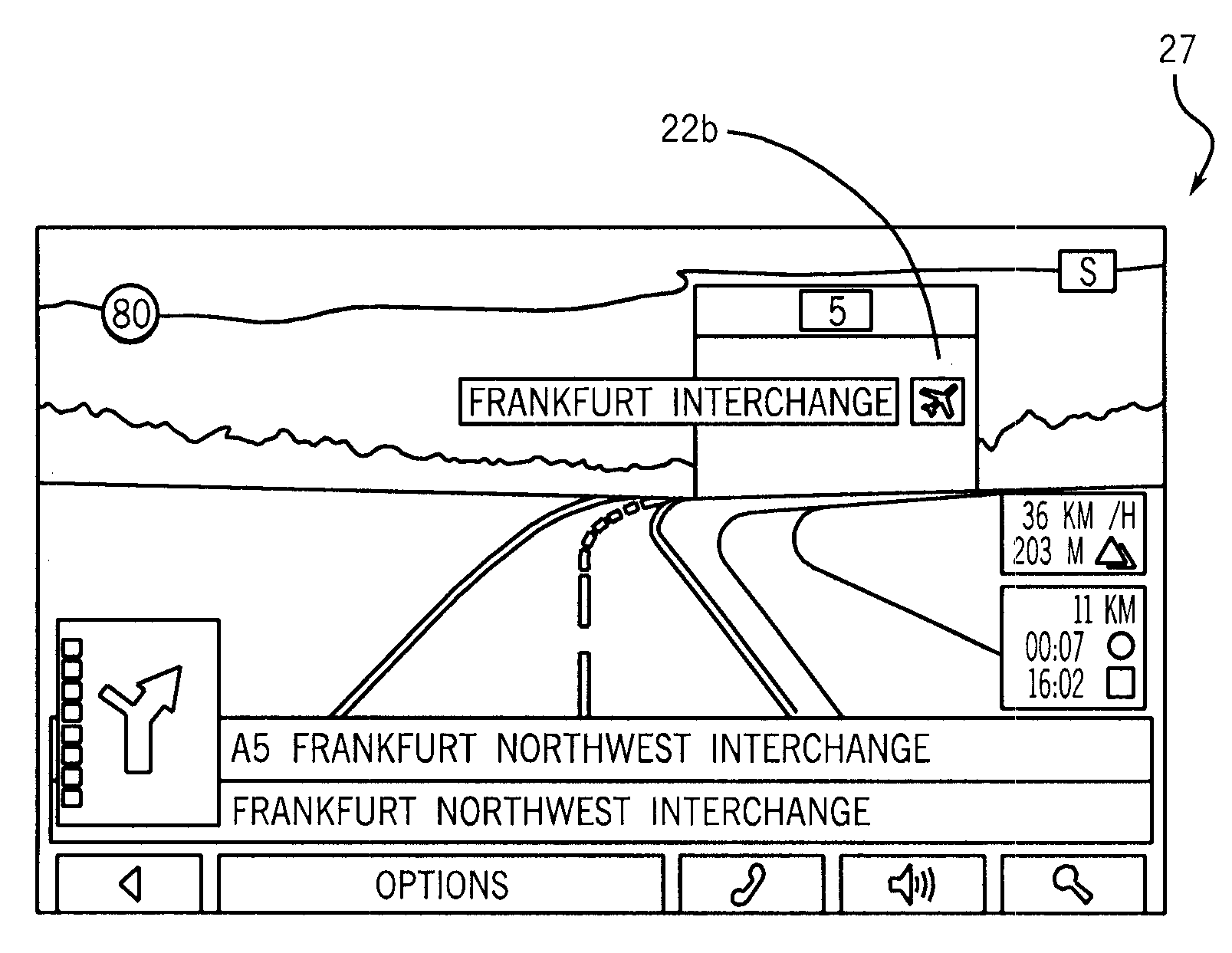
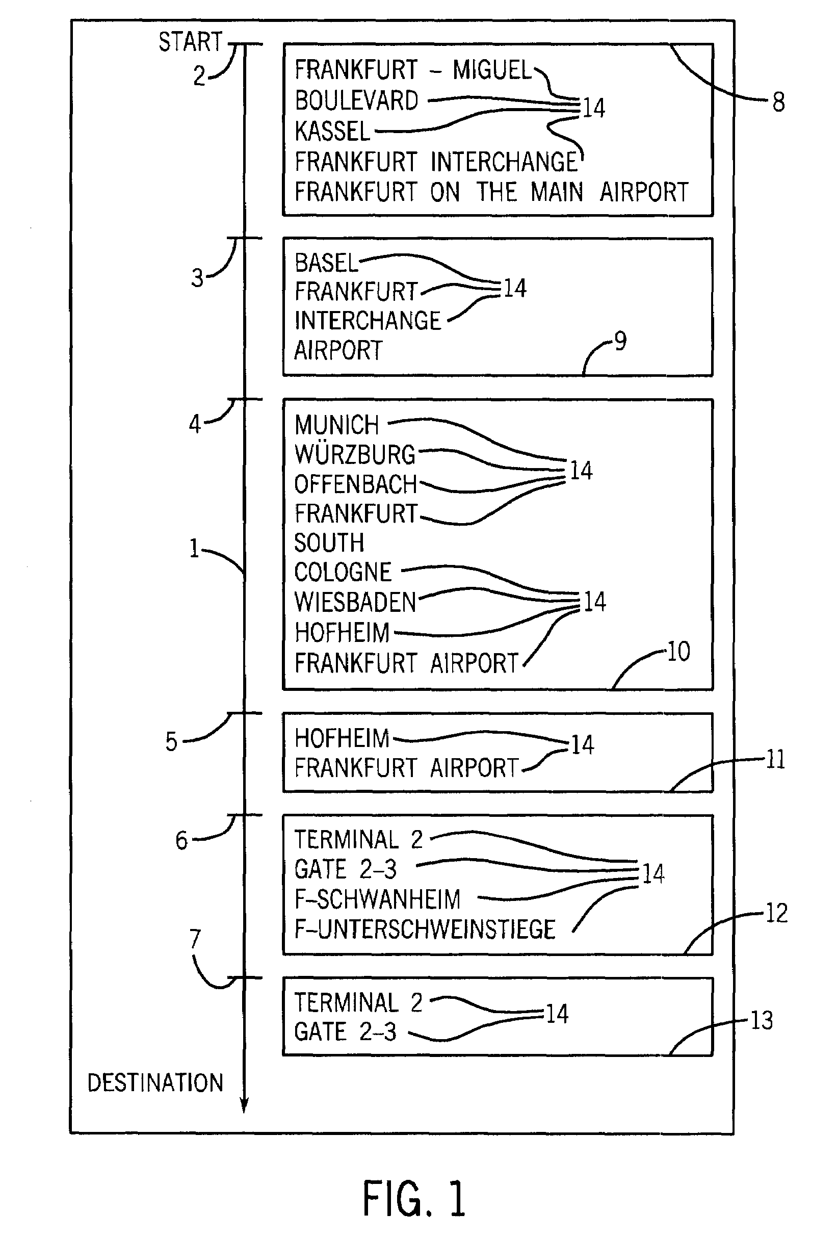
[0043]FIG. 1 symbolically shows a route 01 calculated by a navigation system in the form of a motion arrow from the starting point to the destination. In this case, six signposts 02 to 07 are provided along the route 01. The information on the signposts 02 to 07 is stored in a data base of navigation system in the form of signpost data sets. The signpost data sets 08 to 13 assigned to the signposts 02 to 07 are adjacently assigned to the signposts in FIG. 1. Each signpost data set 08 comprises a multitude of signpost information 14 that describes the destination information on the signposts 02 to 07 in text form. As an alternative to this text form, it would also be possible to provide signpost information in the form of graphic symbols.

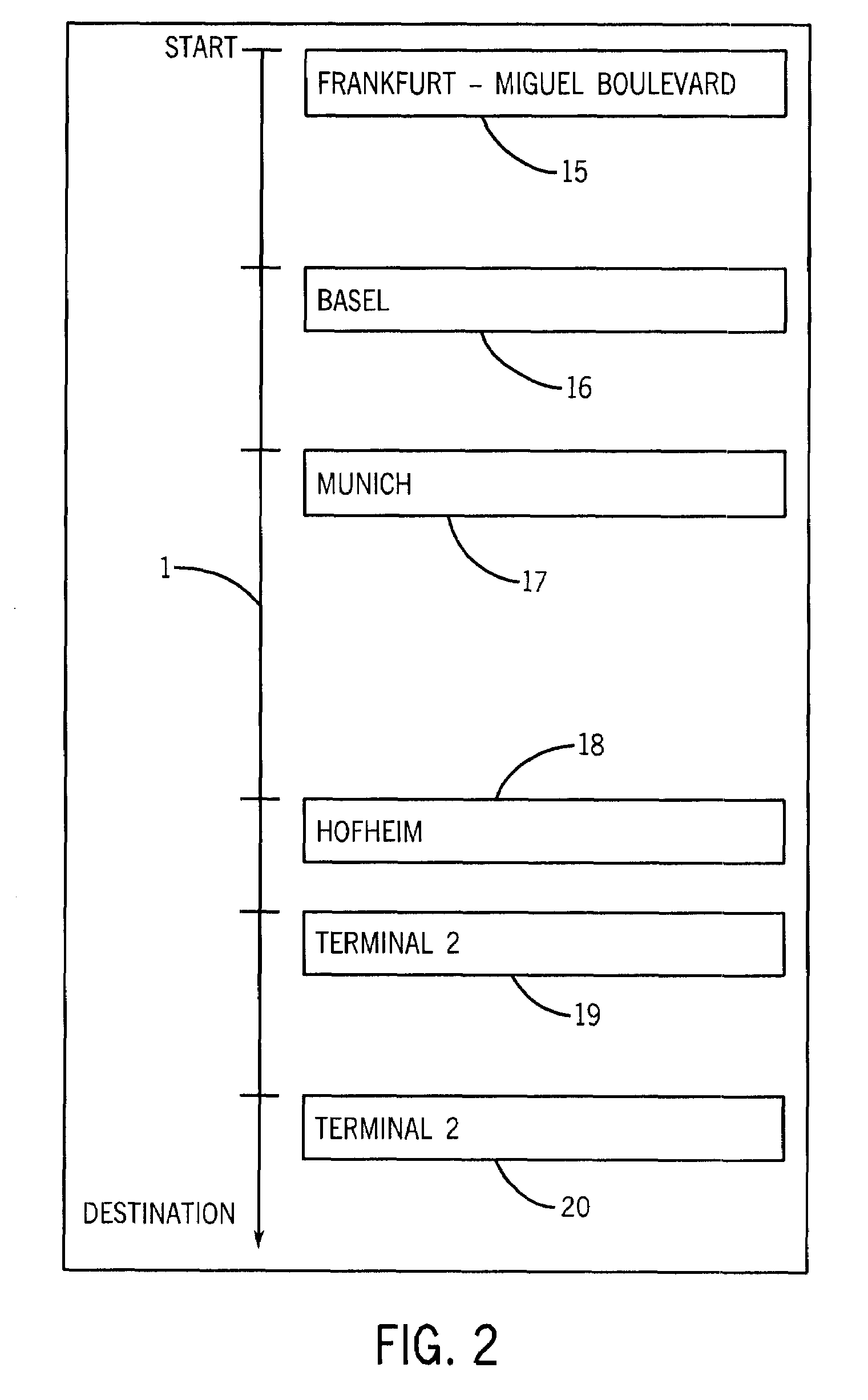
[0044]FIG. 2 schematically shows the generation of signpost messages 15 to 20 that are respectively displayed or announced to the user along the route 01 by means of an output device of the navigation system. According to this figure, the first signp...


PUM


Abstract

The invention pertains to a method for operating a navigation system. The navigation system includes a data base, in which a geographic region is described by means of machine-readable data, wherein the data base also contains signpost data sets that respectively describe the signpost information of signposts in the geographic region, a route calculating unit for calculating a route, a position finding unit that makes it possible to determine the current position, and at least one output device for outputting at least part of a signpost data set; in the form of an optical, anchor acoustical signpost message in dependence on the current position. The method includes the following steps:
a) determining at least two signpost data sets, wherein a first signpost data set describes the signpost information of a first signpost along the route, and wherein a second signpost data set describes die signpost information of a second signpost that lies behind the first signpost along the route,
b) comparing the determined signpost data sets,
c) deriving the signpost message, wherein the content of the signpost message is determined in dependence on the result of the comparison between the determined signpost data sets, and
d) optically and/or acoustically outputting the signpost message.

Description

CROSS-REFERENCE TO RELATED APPLICATION[0001]This application claims the priority benefit of German Patent Application No. 10 2007 027 820.0 filed on Jun. 13, 2007, German Patent Application No. 102007 038 463.9 filed on Aug. 14, 2007, and European Patent Application No. 08 008 500.4 filed on May 6, 2008, the contents: of which are hereby incorporated by reference as if fully set forth herein in their entirety.STATEMENT CONCERNING FEDERALLY SPONSORED RESEARCH OR DEVELOPMENT[0002]Not applicable.FIELD OF THE INVENTION[0003]The invention pertains to a method for operating a navigation system that may be realized, for example, in the form of a mobile navigation device. In this case, the navigation system comprises a data base, in which a certain geographic region is described by means of machine-readable data. This may concern, for example, the road network of Germany, Europe or another geographic unit. This data base also contains, in particular, signpost, data sets. These signpost data...

Claims


Application Information

Patent Timeline
IPC IPC(8): G01C21/34
CPCG01C21/3626G01C21/3655
Inventor KAHLOW, MATTHIASKATZER, JOCHEN
Owner NAVIGON AG
Why Eureka
Try Eureka