Collaborative GPS/INS system and method

a technology of inertial navigation system and gps system, which is applied in surveying and navigation, measurement devices, instruments, etc., can solve the problems of inability to calculate a 3d position, inability to integrate gps and inertial navigation system, and inability to solve the problem of gps outage situation

Inactive Publication Date: 2009-02-05
INTRINSYC SOFTWARE INT
View PDF4 Cites 8 Cited by
  • Summary
  • Abstract
  • Description
  • Claims
  • Application Information

AI Technical Summary

Problems solved by technology

If the GPS receiver is unable to receive signals from a minimum of four satellites at a given instant, it will be unable to calculate a 3D position.
This GPS outage situation often occurs when the GPS satellites are blocked by physical obstacles, including urban environments such as buildings.
The disadvantage is the sub-optimality of its integrated solution and the valid position solutions may not be continuous when there are GPS outages because the number of visible GPS satellites is less than four.
Its disadvantage is that the GPS and INS systems are simply treated as data acquisition systems thus requiring a complicated integration algorithm and, further, the positioning function and capability of the individual systems is not even utilized.
Further, it is also often not even possible for an integrator to know the details of a given GPS or INS implementation, which are often proprietary, and therefore, for some GPS and INS systems, the tightly coupled approach cannot be used by the integrator at all.

Method used


Image

  • Collaborative GPS/INS system and method
  • Collaborative GPS/INS system and method
  • Collaborative GPS/INS system and method

Examples


Embodiment Construction

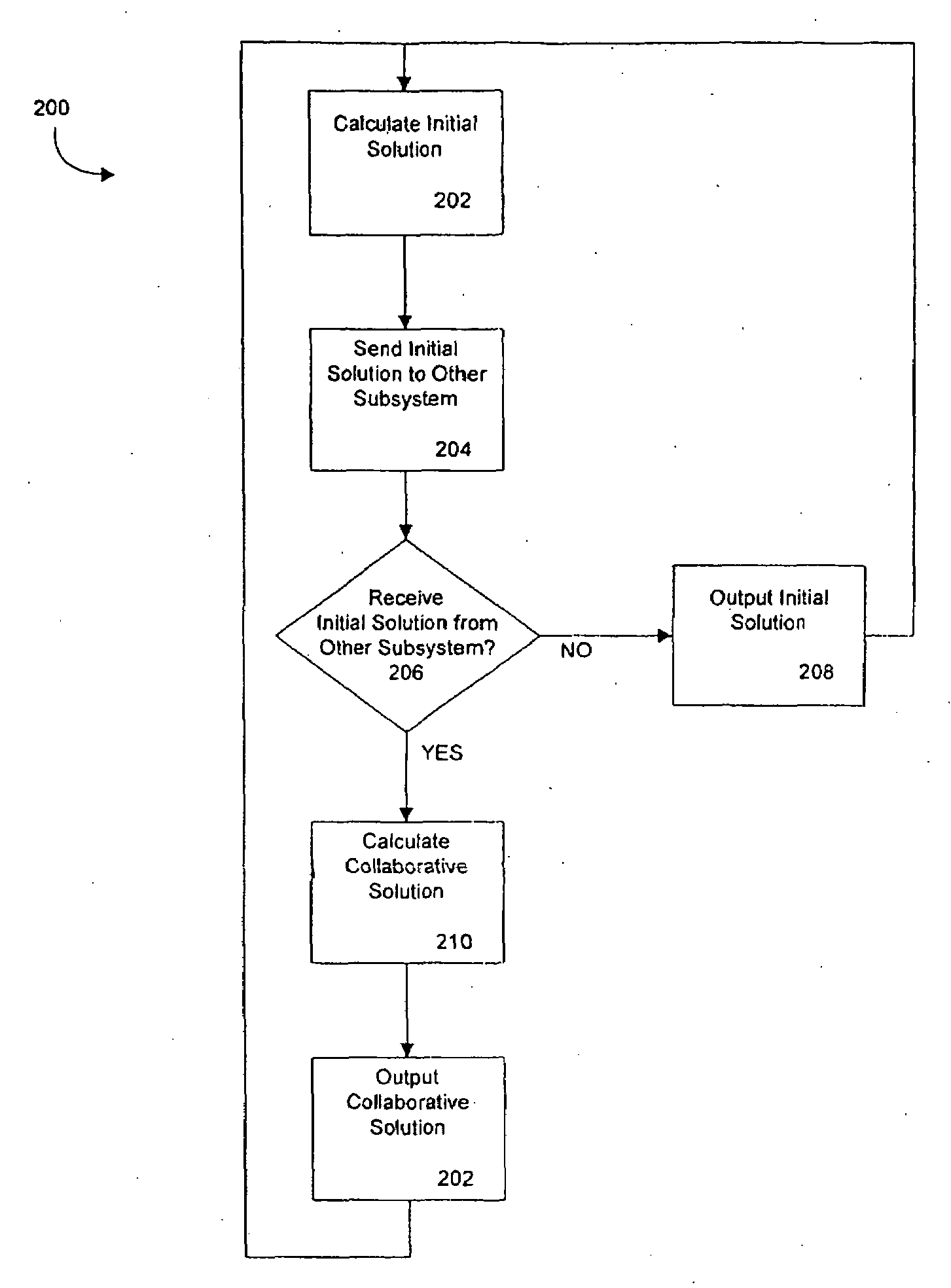
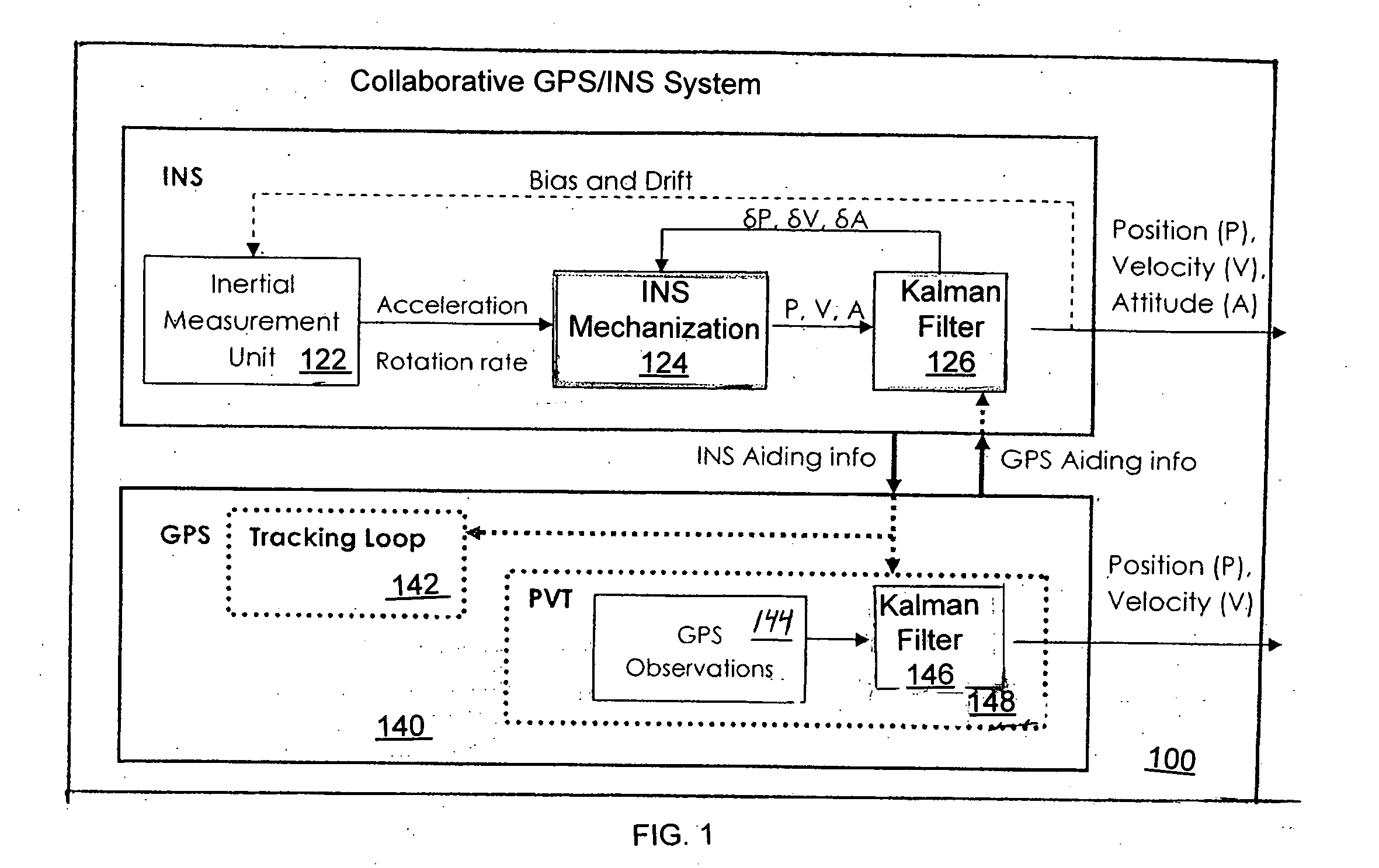
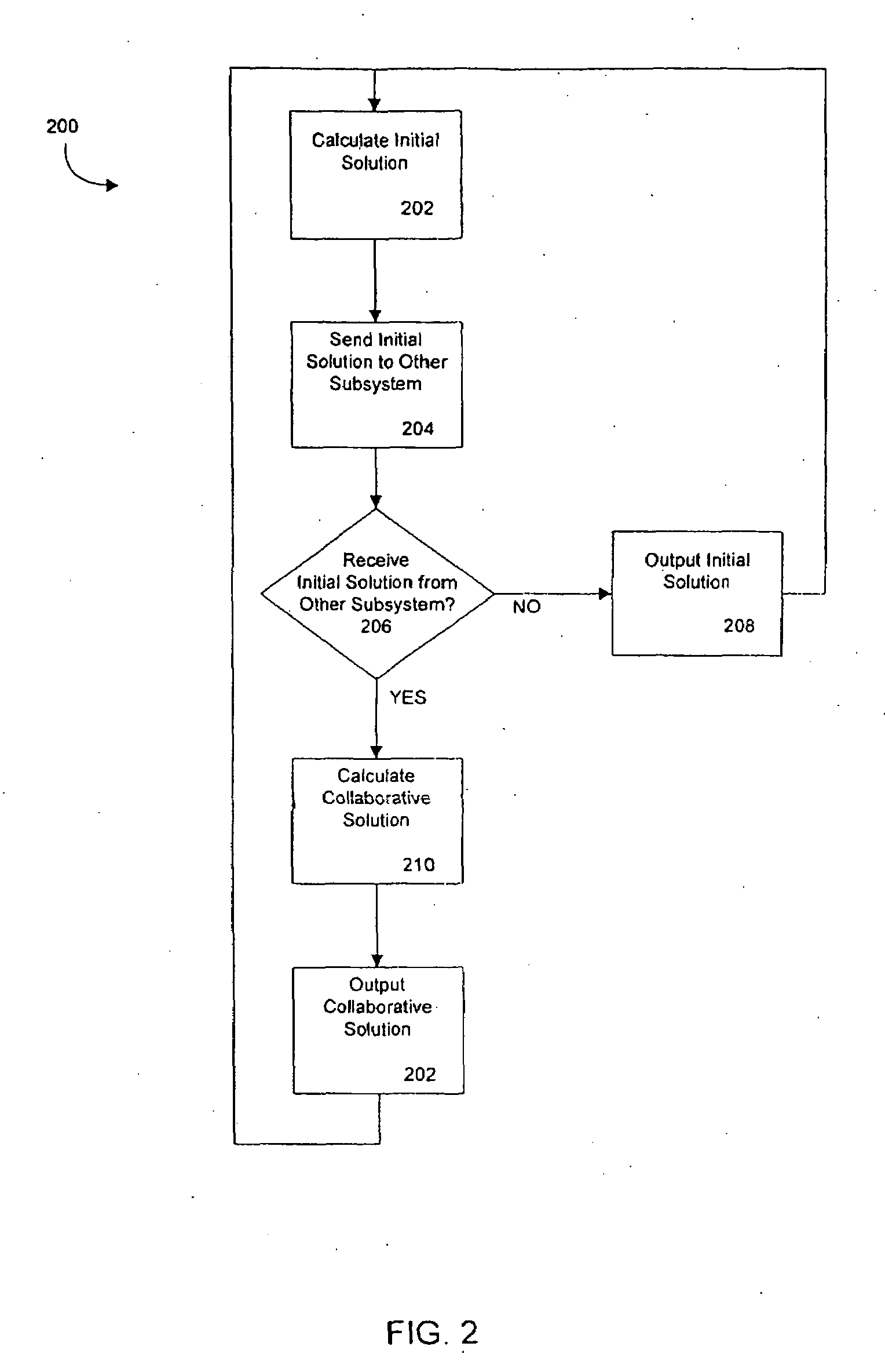
[0022]The present invention is a system and method of collaboration between a GPS subsystem and an INS subsystem. Note that the term INS subsystem as used herein generally refers to any INS system such as an INS / IMU, a Compass, or an Altimeter, or a combination of such systems, used to aid a GPS system. The collaboration method according to some embodiments is for each subsystem to follow a collaborative integration three-step process for every measurement epoch as follows:[0023]1) an initial solution generation step;[0024]2) an aiding step where the initial solution is communicated to another sub-system to be used as aiding information; and,[0025]3) an update step where aiding information received from another subsystem is used to update the initial solution to form a collaborative solution.

In this way, each subsystem generates an improved solution, the collaborative solution, based on its own initial solution aided by that of another subsystem.

[0026]In some embodiments, each subsy...


PUM


Abstract

A real-time integrated Global Positioning System (GPS) and Inertial Navigation System (INS) system in which each aids the other to offer continuously available navigation information by each GPS and INS subsystem calculating an initial solution, providing the initial solution to the other GPS or INS subsystem, and then each GPS and INS subsystem calculating a collaborative solution based on the initial solution received from the other GPS or INS subsystem.

Description

CROSS-REFERENCES[0001]This U.S. nonprovisional patent application claims priority to and the benefit of U.S. provisional patent application No. 60 / 920,241 filed Mar. 26, 2007 and entitled “Continuous Navigation System” which is hereby incorporated by reference herein.BACKGROUND[0002]1. Field of the Invention[0003]The present invention is generally related to positioning and navigational systems and more specifically to integrated Global Positioning System (GPS) and Inertial Navigation System (INS) systems.[0004]2. Related Art[0005]GPS is a well-known satellite-based, all weather, line-of-sight radio navigation and positioning system funded and controlled by the U.S. Department of Defense. It is nominally formed from a constellation of 24 satellites and their ground stations. There are six orbital planes, spaced sixty degrees apart, and inclined at about fifty-five degrees with respect to the equatorial plane.[0006]The concept of positioning with GPS is based on simultaneous ranging ...

Claims


Application Information

Patent Timeline
Patent Type & Authority Applications(United States)
IPC IPC(8): G01C21/00
CPCG01C25/00
Inventor GAVRILINE, ALEXEIYANNI, MAMDOUHGAO, YANGZHANG, YUFENG
Owner INTRINSYC SOFTWARE INT
Why Eureka
Try Eureka