Computer-aided system for 360 degree heads up display of safety/mission critical data

a technology of safety/mission critical data and computer-aided systems, which is applied in the field of aviation, can solve the problems of many critical perceptual limitations of humans piloting aircraft or other vehicles, doctors and medical technicians, and inability to know, and achieve the effect of optimal assessmen

Inactive Publication Date: 2010-09-23
REALTIME
View PDF17 Cites 246 Cited by
  • Summary
  • Abstract
  • Description
  • Claims
  • Application Information

AI Technical Summary

Benefits of technology

[0017]Aside from viewing external information, the health of the aircraft can also be checked by the HUD360 by having a pilot observe an augmented view of the operation or structure of the aircraft, such as of the aileron control surfaces, and be able to see an augmentation of set, min, or max, control surface position. The actual position or shape can be compared with an augmented view of proper (designed) position or shape in order to verify safe performance, such as degree of icing, in advance of critical flight phases, where normal operation is critical such as during landing or take off. This allows a pilot to be more able to adapt in abnormal circumstances where operating surfaces are not functioning optimally.
[0018]Pan, tilt, and zoom cameras mounted in specific locations to see the outside of the aircraft can be used to augment the occluded view of the pilot, where said cameras can follow the direction of the pilots head and allow the pilot to see the outside of what would normally be blocked by the flight deck and vessel structures. For instance, an external gimbaled infrared camera can be used for a pilot to verify the de-icing function of aircraft wings to help verify that the control surfaces have been heated enough by verifying a uniform infrared signature and comparing it to expected normal augmented images. A detailed database on the design and structure, as well as full motion of all parts can be used to augment normal operation that a pilot can see, such as minimum maximum position of control structures. These minimum maximum positions can be augmented in the pilots HUD so the pilot can verify control structures' operation whether they are dysfunctional or operating normally.
[0019]In another example, external cameras in both visible and infrared spectrum on a space craft can be used to help a astronaut easily and naturally verify the structural integrity of the spacecraft control surfaces, that may have been damaged during launch, or to verify the ability of the rocket boosters to contain plasma thrust forces before and during launching or re-entry to earths atmosphere and to determine if repairs are needed and if an immediate abort is needed.
[0020]With the use of both head and eye orientation tracking, objects normally occluded in the direction of a user's gaze (as determined both by head and eye orientation) can be used to display objects hidden from normal view. This sensing of both the head and eye orientation can give the user optimal control of the display augmentation as well as an un-occluded omnidirectional viewing capability freeing the user's hands to do the work necessary to get a job done simultaneously and efficiently.
[0021]The user can look in a direction of an object and either by activating a control button or by speech recognition selects the object. This can cause the object to be highlighted and the system can then provide further information on the selected object. The user can also remove or add layers of occlusions by selecting and requesting a layer to be removed. As an example, if a pilot is looking at an aircraft wing, and the pilot wants to look at what is behind the wing, the pilot can select a function to turn off wing occlusion and have video feed of a gimbaled zoom camera positioned so that the wing does not occlude it. The camera can be oriented to the direction of the pilots head and eye gaze, whereby a live video slice from the gimbaled zoom camera is fed back and projected onto the semi transparent display onto the pilot's perception of the wing surface as viewed through the display by perceptual transformation of the video and the pilots gaze vector. This augments the view behind the wing.
[0024]Gimbaled zoom camera perceptions, as well as augmented data perceptions (such as known 3D surface data, 3D floor plan, or data from other sensors from other sources) can be transferred between pilot, crew, or other cooperatives with each wearing a gimbaled camera (or having other data to augment) and by trading and transferring display information. For instance, a first on the scene fire-fighter or paramedic can have a zoom-able gimbaled camera that can be transmitted to other cooperatives such as a fire chief, captain, or emergency coordinator heading to the scene to assist in an operation. The control of the zoom-able gimbaled camera can be transferred allowing remote collaborators to have a telepresence (transferred remote perspective) to inspect different aspects of a remote perception, allowing them to more optimally assess, cooperate and respond to a situation quickly.

Problems solved by technology

There are many critical perceptual limitations to humans piloting aircraft or other vehicles as well as doctors and medical technicians implementing procedures on patients, or operators trying to construct or repair equipment or structures, or emergency personnel attempting to rescue people or alleviate a dangerous situation.
For pilots of aircraft, many of these limitations include occlusion by aircraft structures that keep the pilot from seeing weather conditions, icing on wings and control structures, conditions of aircraft structures, terrain, buildings, or lack of adequate day-light, as well as not knowing the flight plan, position, speed, and direction of other known aircraft, or the position, speed, and direction of unknown aircraft, structures, or flocks of birds received from radar or other sensor data.
Further, technicians or operators that maintain vehicles or other systems have their visual perception obstructed by structures and objects that prevent them from seeing the objects and structures that need to be modified.
Police and military personnel may have their perception occluded from building and terrain structures, as well as from weather conditions, and are missing the perception of others helping out in an operation.

Method used


Image

  • Computer-aided system for 360 degree heads up display of safety/mission critical data
  • Computer-aided system for 360 degree heads up display of safety/mission critical data
  • Computer-aided system for 360 degree heads up display of safety/mission critical data

Examples


Embodiment Construction

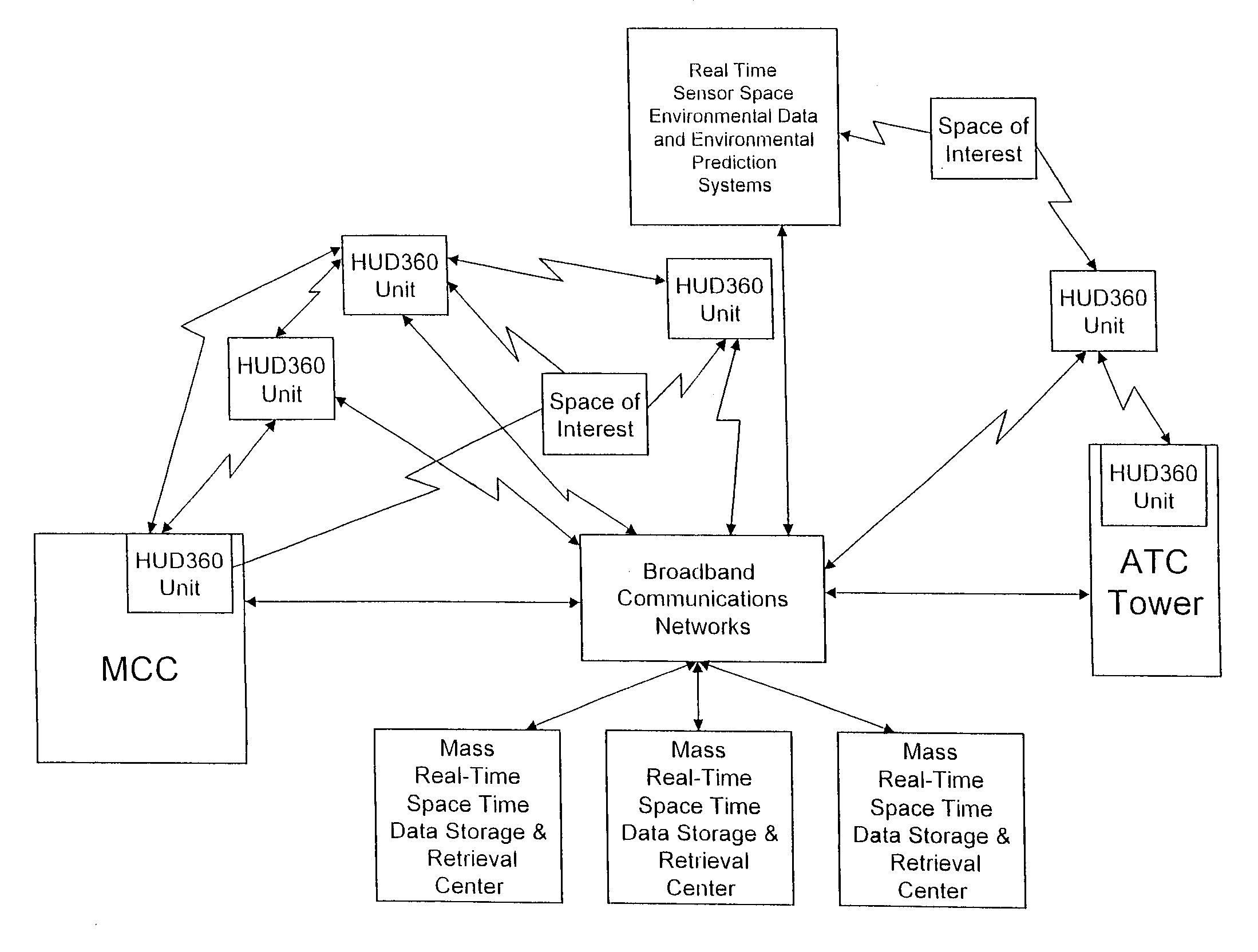
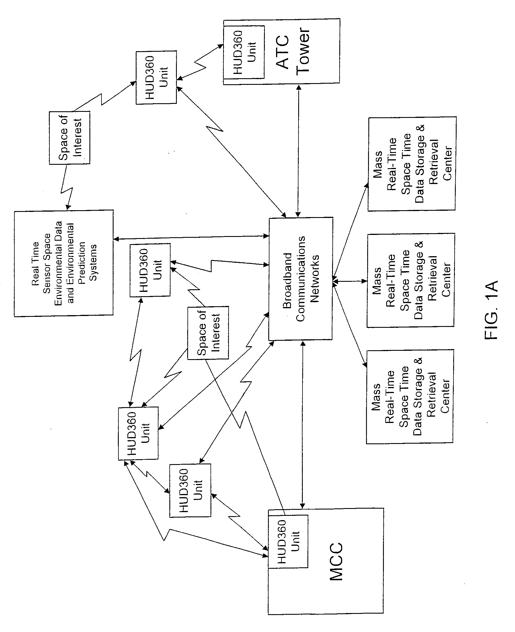
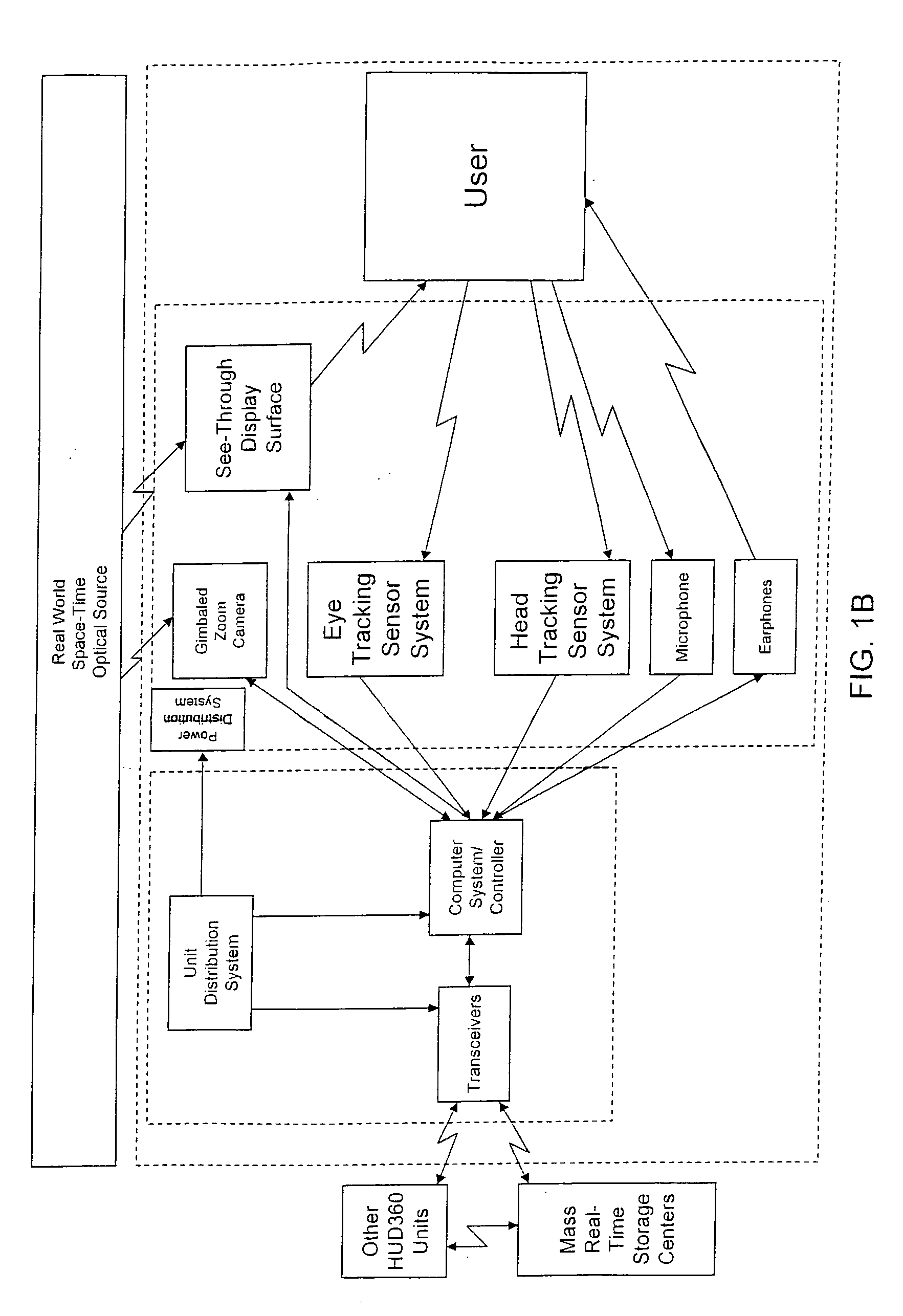
[0061]A functional system block diagram of a HUD360 1 system with see-through display surface 4 viewed by a user 6 of a space of interest 112 is shown in FIG. 1A. In some applications, the HUD360 1 see-through display surface 4 can be set in an opaque mode where the entire display surface 4 has only augmented display data where no external light is allowed to propagate through display surface 4. Other features of the HUD360 1 system include a head tracking sub-system 110, an eye tracking sub-system 108, and a microphone 5 are all shown in FIG. 1A and all of which can be used as inputs with the ability to simultaneously control the augmented see-through display view 4, or to control another available system of the user's 6 choice. Also shown is a pair of optional earphones 11 which can also be speakers to provide output to user 6 that can complement the augmented output of the see-through display surface 4. Also shown in FIG. 1A is an optional gimbaled zoom camera that can be a lone ...


PUM


Abstract

A safety critical, time sensitive data system for projecting safety / mission critical data onto a display pair of Commercial Off The Shelf (COTS) light weight projection glasses or monocular creating a virtual 360° HUD (Heads Up Display) with 6 degrees of freedom movement. The system includes the display, the workstation, the application software, and inputs containing the safety / mission critical information (Current User Position, Total Collision Avoidance System—TCAS, Global Positioning System—GPS, Magnetic Resonance Imaging—MRI Images, CAT scan images, Weather data, Military troop data, real-time space type markings etc.). The workstation software processes the incoming safety / mission critical data and converts it into a three dimensional space for the user to view. Selecting any of the images may display available information about the selected item or may enhance the image. Predicted position vectors may be displayed as well as 3D terrain.

Description

FIELD OF THE INVENTION[0001]This invention is based primarily in the aviation field but also has applications in the medical, military, police, fire, leisure, and automotive fields as well as applications in areas requiring displaying various data onto a 3 dimensional orthogonal space. The user, simply by moving the user's head and / or eyes, achieves different views of the data corresponding to the direction of the user's gaze.BACKGROUND OF THE INVENTION[0002]There are many critical perceptual limitations to humans piloting aircraft or other vehicles as well as doctors and medical technicians implementing procedures on patients, or operators trying to construct or repair equipment or structures, or emergency personnel attempting to rescue people or alleviate a dangerous situation. To overcome many of these perceptual limitations, a technique called augmented reality has been developed, to provide necessary and relevant information outside the immediate local perception of the user th...

Claims


Application Information

Patent Timeline
Patent Type & Authority Applications(United States)
IPC IPC(8): A61B5/05G09G5/00
CPCA61B3/113A61B5/11G02B27/017G02B2027/0138G06F3/013G02B2027/0178G06F3/011G06F3/012G02B2027/014
Inventor VARGA, KENNETHYOUNG, JOELCOVE, PATTYHIETT, JOHN
Owner REALTIME
Why Eureka
Try Eureka