Method For Operating A Navigation System

a navigation system and navigation system technology, applied in traffic control systems, surveying and navigation, instruments, etc., can solve problems such as limiting user friendliness and presenting type of display as a potential safety risk

Inactive Publication Date: 2009-02-26
NAVIGON AG
View PDF4 Cites 76 Cited by
  • Summary
  • Abstract
  • Description
  • Claims
  • Application Information

AI Technical Summary

Benefits of technology

[0011]Based on this state of the art, the present invention aims to propose a new method for operating a navigation system that utilizes combination symbols and makes it possible to improve the user friendliness, as well as the traffic safety.

Problems solved by technology

Depending on the scale of the map image shown, it may be problematic if several Points of Interest lie in a common local area, i.e., if they are arranged closely adjacent to one another.
This type of display has the disadvantage that the POI-symbol information assigned to the combination symbol is only displayed for the user after corresponding user interaction.
This restricts the user friendliness.
If the navigation system is used in a motor vehicle, this type of display also represents a potential safety risk because the user is briefly distracted from traffic while the combination symbol is accessed.

Method used


Image

  • Method For Operating A Navigation System
  • Method For Operating A Navigation System
  • Method For Operating A Navigation System

Examples


Embodiment Construction

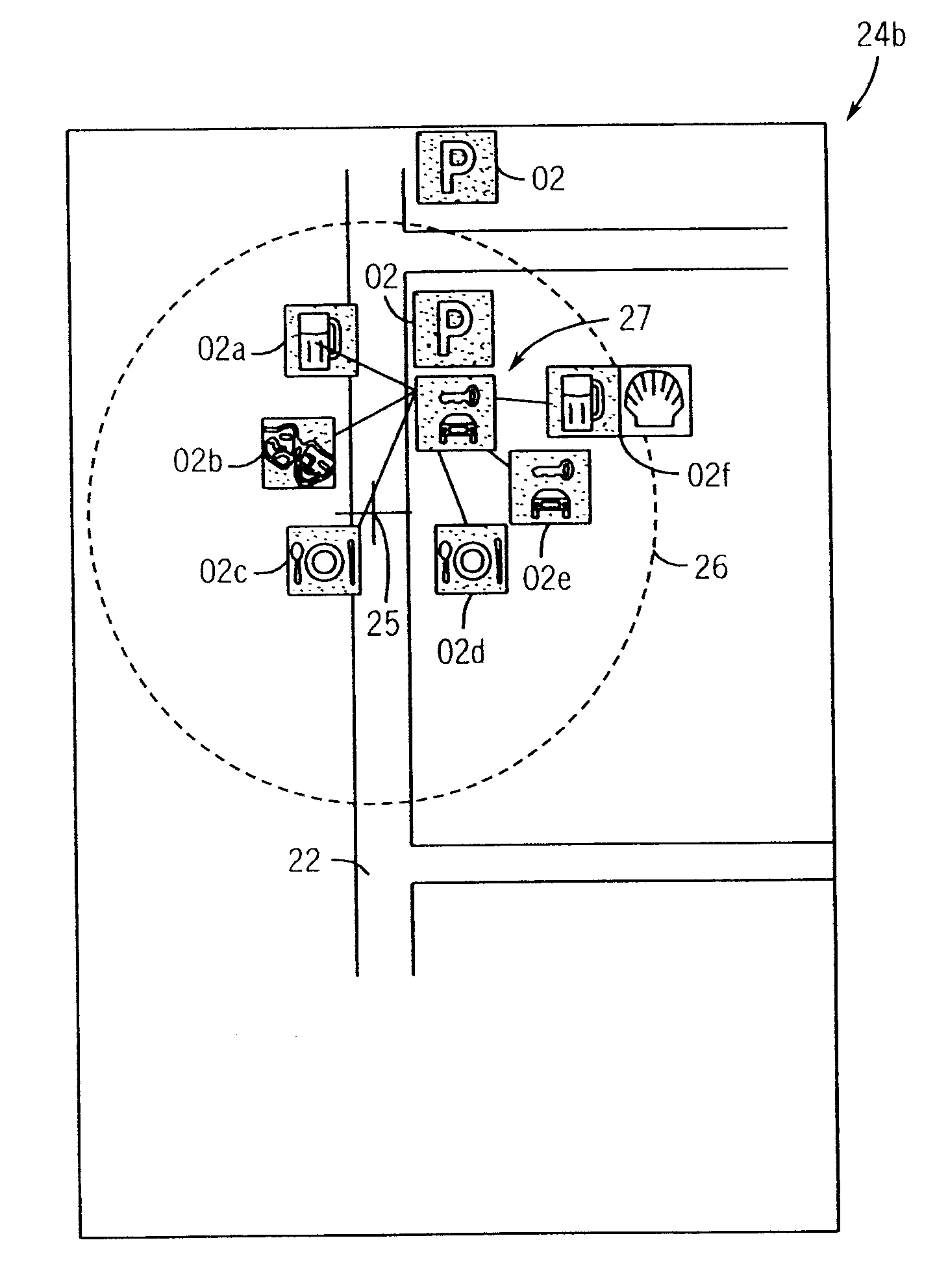
[0045]FIG. 1 shows a combination symbol 01 for jointly displaying several POI-symbols 02. The combination symbol 01 comprises a display area 03, on which the different POI-symbols assigned to the combination symbol are displayed in an alternating fashion. The combination symbol 01 furthermore comprises a stack symbol 04 that is composed of two panels 05 and 06 in the embodiment shown in FIG. 1.

[0046]Since the combination symbol 01 is intended for being displayed in 2D images, the display area 03 is arranged such that it lies on the panels 05 and 06 of the stack symbol 04. Consequently, the display area 03 almost completely covers the panels 05 and 06 of the stack symbol 04 and only the edges of the panels 05 and 06 of the stack symbol 04 protrude over the display area 03.

[0047]FIG. 2 shows a second embodiment 07 of a combination symbol that is also intended for being displayed in 2D images. POI-symbols 02 can also be displayed in an alternating fashion in the display area 03 of the ...


PUM


Abstract

A method for operating a navigation system includes the following steps:a) calculating and displaying a map image on a display device, wherein the map image represents at least a section of a geographic area;b) selecting locations to be highlighted (Points of Interest, POI) that lie in the region of the geographic area displayed and are respectively assigned to one POI-symbol in the map image from a data base, andc) displaying the POI-symbols in the map image, wherein the POI-symbols that symbolize the locations to be highlighted within a common local area are displayed in the form of a common combination symbol such that one combination symbol respectively represents several POI-symbols, wherein the combination symbol features at least one display area, in which at least one POI-symbol can be displayed, and wherein the POI-symbols assigned to the combination symbol are alternately displayed in the display area.

Description

CROSS-REFERENCE TO RELATED APPLICATION[0001]This application claims the priority benefit of German Patent Application No. 10 2007 037 386.6 filed on Aug. 8, 2007, the contents of which are hereby incorporated by reference as if fully set forth herein in their entirety.STATEMENT CONCERNING FEDERALLY SPONSORED RESEARCH OR DEVELOPMENT[0002]Not applicable.FIELD OF THE INVENTION[0003]The invention pertains to a method for operating a navigation system and in particular, a method of operating a navigation system that displays at least one point of interest.BACKGROUND OF THE INVENTION[0004]In known navigation systems such as, for example, mobile navigation devices for motor vehicles, it is common practice to display a map image on a display device. This map image represents a section of a geographic area and also shows, for example, the corresponding road network in order to provide the user with a corresponding overview.[0005]A navigation system of the generic type also contains a databas...

Claims


Application Information

Patent Timeline
Patent Type & Authority Applications(United States)
IPC IPC(8): G06F3/048G01C21/20G06F3/0483
CPCG06F3/0483G01C21/3682
Inventor JOACHIM, STEFFEN
Owner NAVIGON AG
Why Eureka
Try Eureka