Sun-shadow simulation in a geospatial system

a geospatial system and shadow simulation technology, applied in the field of three-dimensional (3d) applications, can solve the problems of prior art gis systems not providing the capability to combine gis data with additional information in order to visualize, analyze, simulate trends, phenomena, states, etc., and prior art gis systems also fail to provide such capabilities

Active Publication Date: 2009-04-09
AUTODESK INC
View PDF33 Cites 66 Cited by
  • Summary
  • Abstract
  • Description
  • Claims
  • Application Information

AI Technical Summary

Benefits of technology

[0011]Certain cities may have regulations that prohibit shadows from being cast on neighboring buildings. Alternatively, users may desire to view the effect of the sun on a building when designing the placement or architecture of the building.

Problems solved by technology

However, prior art GIS systems fail to provide the capability to merge GIS data with additional information in order to visualize, analyze, and simulate trends, phenomena, states, and events.
Further, three-dimensional (3D) systems also fail to provide such capabilities.
In addition, prior art systems fail to provide the ability for a user to easily visualize how the sun and shadow produced by objects in a 3D environment.
Prior art systems further fail to provide the ability to directly control the sun / shadow settings for time of day and day of year in such a visualization.

Method used


Image

  • Sun-shadow simulation in a geospatial system
  • Sun-shadow simulation in a geospatial system
  • Sun-shadow simulation in a geospatial system

Examples


Embodiment Construction

[0025]In the following description, reference is made to the accompanying drawings which form a part hereof, and which is shown, by way of illustration, several embodiments of the present invention. It is understood that other embodiments may be utilized and structural changes may be made without departing from the scope of the present invention.

Overview

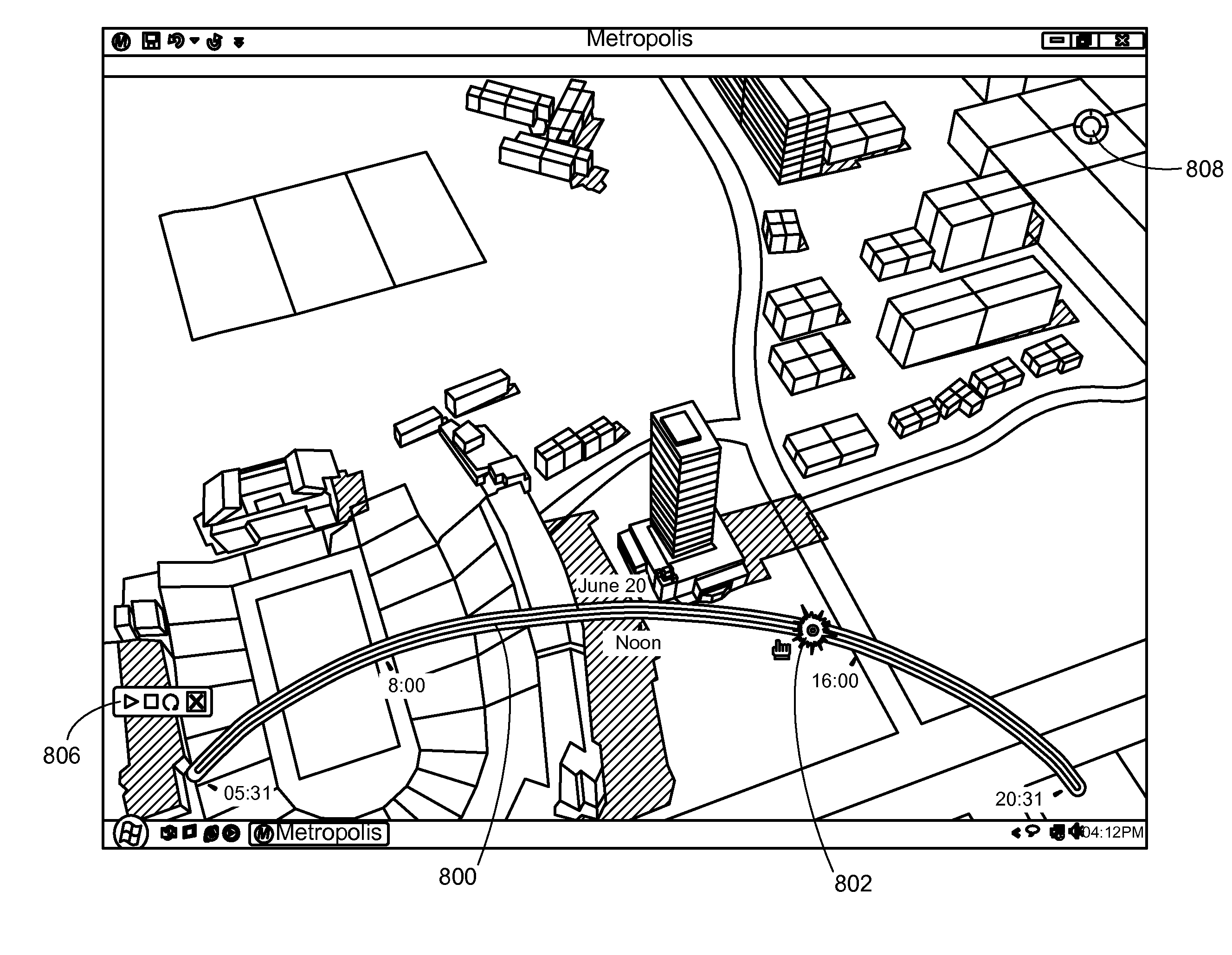
[0026]One or more embodiments of the invention provide an application and development framework for aggregating design models and GIS data within an immersive 3D geospatial environment for the purposes of visualizing, analyzing, and simulating trends, phenomena, state, and events in ways that are not possible within conventional 2D GIS or existing 3D application software. In other words, embodiments of the invention provide the ability to view, analyze, simulate trends, phenomena, states, and events in a digital city.

[0027]The benefits of the embodiments of the invention include:

[0028]3D Geospatial Environment containing both simplif...


PUM


Abstract

A method, apparatus, and article of manufacture provide the ability to display a sun and shadow simulation in a 3D system. A 3D view of a real world scene is displayed, using a 3D graphics application, on a display device. A plug-in is installed into the application. A calendar period (e.g., a month, day, and year) is defined by the user. A timeline arc is displayed with the calendar period defining a radius of the arc, and starting stopping endpoints of the timeline arc defining an interval of time during the calendar period. A timeline slider is displayed on the arc that indicates a time of day within the calendar period. A visualization is displayed, in the 3D view, of shadows cast by a sun on objects in the 3D view. A position of the sun is based on the calendar period and the time of day.

Description

CROSS-REFERENCE TO RELATED APPLICATIONS[0001]This application claims the benefit under 35 U.S.C. Section 119(e) of the following co-pending and commonly-assigned U.S. provisional patent application(s), which is / are incorporated by reference herein:[0002]Provisional Application Ser. No. 60 / 997,868, filed Oct. 5, 2007, by RICHARD D. HOWARD, JARROD LOPICCOLO, GRANT ANDERSON, ROY LINDAUER, THOMAS HELMAN, and MATTHEW LARSEN, entitled “FRAMEWORK FOR AGGREGATING DESIGN MODELS AND GIS DATA IN A GEOSPATIAL ENVIRONMENT,” attorneys' docket number 30566.420-US-P1[0003]This application is related to the following co-pending and commonly-assigned patent application, which application is incorporated by reference herein:[0004]U.S. patent application Ser. No. ______, entitled “USER DEFINED SCENARIOS IN A THREE DIMENSIONAL GEO-SPATIAL SYSTEM”, by Richard D. Howard, Jarrod Lopiccolo, Grant Anderson, Roy Lindauer, Thomas Helman, and Matthew Larsen, Attorney Docket No. 30566.420-US-U1, filed on the sam...

Claims


Application Information

Patent Timeline
Patent Type & Authority Applications(United States)
IPC IPC(8): G06F3/048
CPCG06F17/30241G06T17/05G06T19/00G06F16/29
Inventor HOWARD, RICHARD D.
Owner AUTODESK INC
Why Eureka
Try Eureka