Route calculation based on traffic events

a technology of route calculation and traffic events, applied in the field of global positioning systems, can solve the problems of requiring more time to travel and delay travel on the roadway

Inactive Publication Date: 2009-04-23
INTRINSYC SOFTWARE INT
View PDF9 Cites 55 Cited by
  • Summary
  • Abstract
  • Description
  • Claims
  • Application Information

AI Technical Summary

Benefits of technology

[0009]A Global Positioning System (GPS)-enabled navigation device is configured to determine whether to calculate a new route based on traffic events. The navigation device provides an initial route based on an origin location and a destination location. If a traffic message is received that includes information about a traffic event along a remaining portion of the initial route, a traffic event delay is determined. A total travel delay is then calculated by summing the determined traffic event delays. A new route is calculated to avoid the traffic event(s). A travel time of the new route is compared to a travel time of the initial route plus the travel delay. If the travel time of the new route is shorter than the travel time of the initial route plus the travel delay, the new route is provided to the user.
[0010]According to various embodiments, a system comprises a global positioning system, a traffic message receiver, a delay module, a route module and a comparison module. The global positioning system module is configured to determine a current location. The traffic message receiver is configured to receive traffic messages each having an event code and a location code. The delay module is configured to determine a traffic event delay for each of the traffic messages having a location code that corresponds to a remaining segment of a first route from an origin location to a destination location. The delay module is further configured to calculate a travel delay based on one or more of the traffic event delays. The route module is configured to calculate a new route from the current location to the destination location, the new route having a new travel time. The comparison module is configured to compare the new travel time of the new route to a remaining travel time of the first route between the current location and the destination location plus the travel delay and output the new route if the new travel time is less than the remaining travel time plus the travel delay.
[0011]According to various embodiments, a method comprises determining a current location of a navigation device; receiving one or more traffic messages each having an event code and a location code; determining a traffic event delay for each of the one or more traffic messages where the location code of the one or more traffic messages corresponds to a remaining segment of a first route from an origin location to a destination location; calculating a travel delay based on one or more of the traffic event delays; calculating a new route from the current location to the destination location, the new route having a new travel time; comparing the new travel time of the new route to a remaining travel time of the first route from the current location to the destination location plus the travel delay; and outputting the new route if the new travel time is less than the remaining travel time plus the travel delay.
[0012]According to various embodiments, a computer readable medium has embodied thereon instructions executable by a processor for performing a method for calculating a route based on traffic events. The method comprises determining a current location of a navigation device; receiving one or more traffic messages each having an event code and a location code; determining a traffic event delay for each of the one or more traffic messages where the location code corresponds to a remaining segment of a first route from an origin location to a destination location; calculating a travel delay based on one or more of the traffic event delays; calculating a new route from the current location to the destination location, the new route having a new travel time; comparing the new travel time of the new route to a remaining travel time of the first route from the current location to the destination location plus the travel delay; and outputting the new route if the new travel time is less than the remaining travel time plus the travel delay.

Problems solved by technology

Traffic events such as accidents, congestion, roadwork, weather conditions, or the like can delay travel on roadways.
However, depending upon the type and extent of the traffic event, an automatically calculated new route may actually require more time to travel than the original route with the delay.
Similarly, if the user is given the option of having the GPS-enabled device calculate the new route, the user may inadvertently have a new route calculated when the original route with the travel delay would have required less travel time.

Method used


Image

  • Route calculation based on traffic events
  • Route calculation based on traffic events
  • Route calculation based on traffic events

Examples


Embodiment Construction

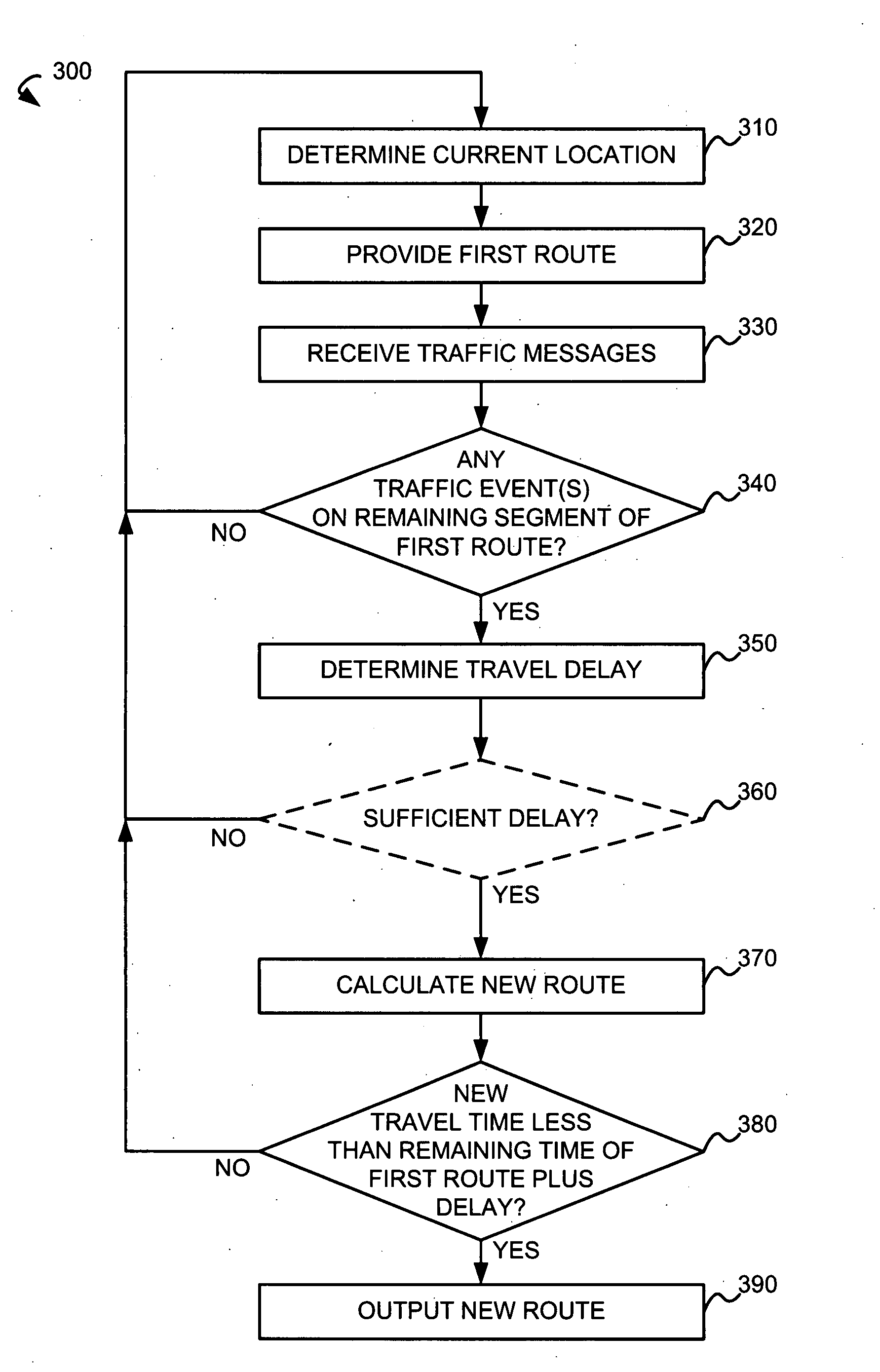
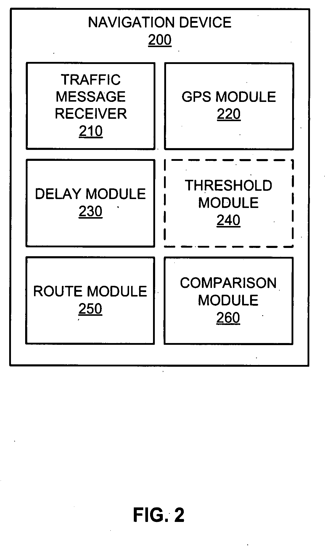
[0017]A Global Positioning System (GPS)-enabled navigation device is configured to determine its current location and provide an initial route from an origin location to a destination location. The navigation device receives traffic messages each containing an event code and a location code corresponding to a traffic event. The navigation device is configured to determine whether any of the received traffic events are on remaining segment(s) of the initial route based on the location code in the corresponding traffic message and the current location.

[0018]If any traffic events are on remaining segment(s) of the initial route, the navigation device is configured to determine a traffic event delay caused by the traffic event based on the event code in the traffic message. In some embodiments, the traffic event delay is also based on the location code in the traffic message. A travel delay is calculated by summing traffic event delay(s) corresponding to each of the traffic events along...


PUM


Abstract

Based on an origin location and a destination location, a navigation device is configured to provide an initial route. Traffic messages describing traffic events are received by the navigation device. Based on a location code in each of the traffic messages, the navigation device determines a traffic event delay if the location code corresponds to any remaining segment(s) of the initial route. If at least one of the traffic messages corresponds to any remaining segment(s) of the initial route, a travel delay is calculated based on one or more traffic event delays. The navigation device calculates a new route from the current location to the destination location, and, if a new travel time of the new route is less than a remaining travel time of the initial route from the current location to the destination location plus the travel delay, the navigation device outputs the new route.

Description

BACKGROUND[0001]1. Field of the Invention[0002]This invention relates generally to the field of global positioning systems (GPS) and more specifically to route calculation based on traffic events.[0003]2. Description of the Related Art[0004]A GPS-enabled device is able to determine a current location. As is known in the art, the GPS-enabled device includes road maps or topographical maps and is able to correlate its current location to these maps. Further, using these maps and its known current location, the GPS-enabled device can calculate a route to a destination location and provide that route to a user.[0005]Traffic events such as accidents, congestion, roadwork, weather conditions, or the like can delay travel on roadways. Currently, the GPS-enabled device may receive previously prepared traffic roadmaps or other indications of traffic events. If a traffic event is on the provided route, the GPS-enabled device may automatically calculate a new route or provide an option to the ...

Claims


Application Information

Patent Timeline
Patent Type & Authority Applications(United States)
IPC IPC(8): G01C21/34G01S5/00G06F17/00
CPCG01C21/3492G01C21/3415
Inventor BITAN, RONEN
Owner INTRINSYC SOFTWARE INT
Why Eureka
Try Eureka