Sbas navigation data update notifying system and method used in gbas

a technology of sbas navigation and notifying system, applied in satellite radio beaconing, measurement devices, instruments, etc., can solve the problems of deteriorating positioning accuracy, four factors that cannot be satisfied with a navigation system, and the airborne system side is not able to know the gbas navigation data, so as to improve the safety

Active Publication Date: 2009-10-08
NEC CORP
View PDF3 Cites 19 Cited by
  • Summary
  • Abstract
  • Description
  • Claims
  • Application Information

AI Technical Summary

Benefits of technology

[0017]An exemplary object of the present invention is to provide an SBAS navigation data update notifying system and method used in GBAS, which can improve the safety by avoiding deterioration in a positioning accuracy through using the same navigation data in a ground system and in an airborne system by employing a satellite navigation augmentation system (GBAS: Ground Based Augmentation System).

Problems solved by technology

However, the four factors cannot be satisfied with a navigation system which uses only a GPS satellite but uses no augmentation system.
When the GBAS Type 1 generated by a standard designing method based on the specification is used, it is not possible for the airborne system side to know the GBAS navigation data that is used when the ground system generates the GBAS type 1 data.
Thus, use of different data in the ground system and in the airborne system leads to deteriorating the positioning accuracy.
The GBAS is a system used in navigations of the airplanes, so that deterioration of the positioning accuracy may endanger people's lives.
Therefore, when the correction-target satellite is the SBAS satellite, the airborne system cannot specify the SBAS navigation data that is used by the ground system.

Method used


Image

  • Sbas navigation data update notifying system and method used in gbas
  • Sbas navigation data update notifying system and method used in gbas
  • Sbas navigation data update notifying system and method used in gbas

Examples


Embodiment Construction

[0028]Hereinafter, exemplary embodiments of the invention will be described in detail by referring to the accompanying drawings.

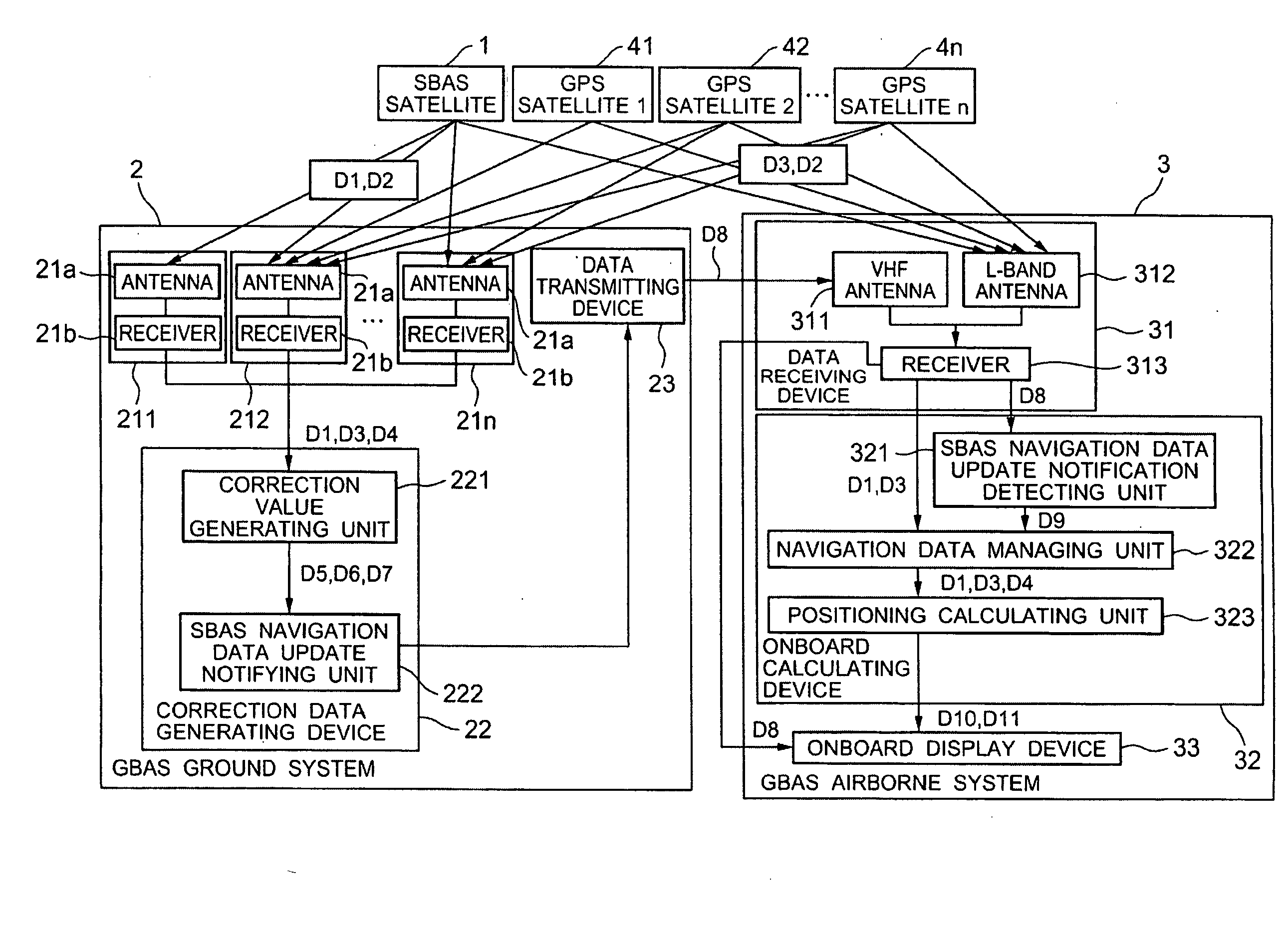
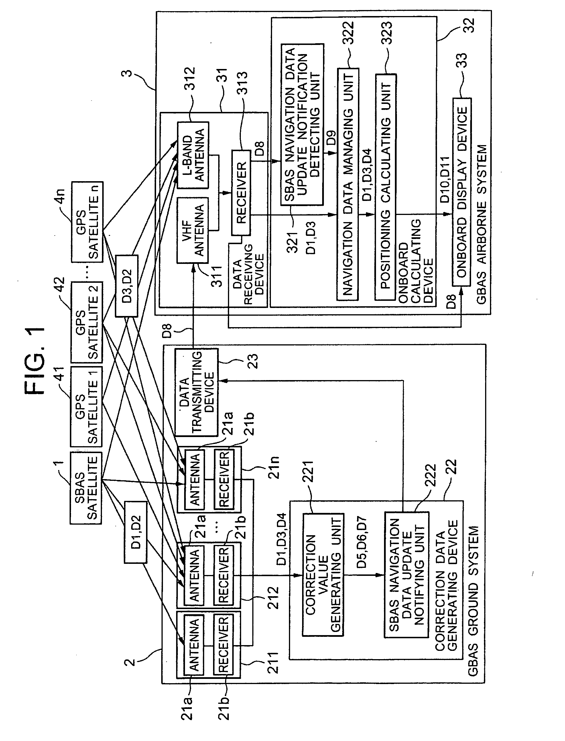
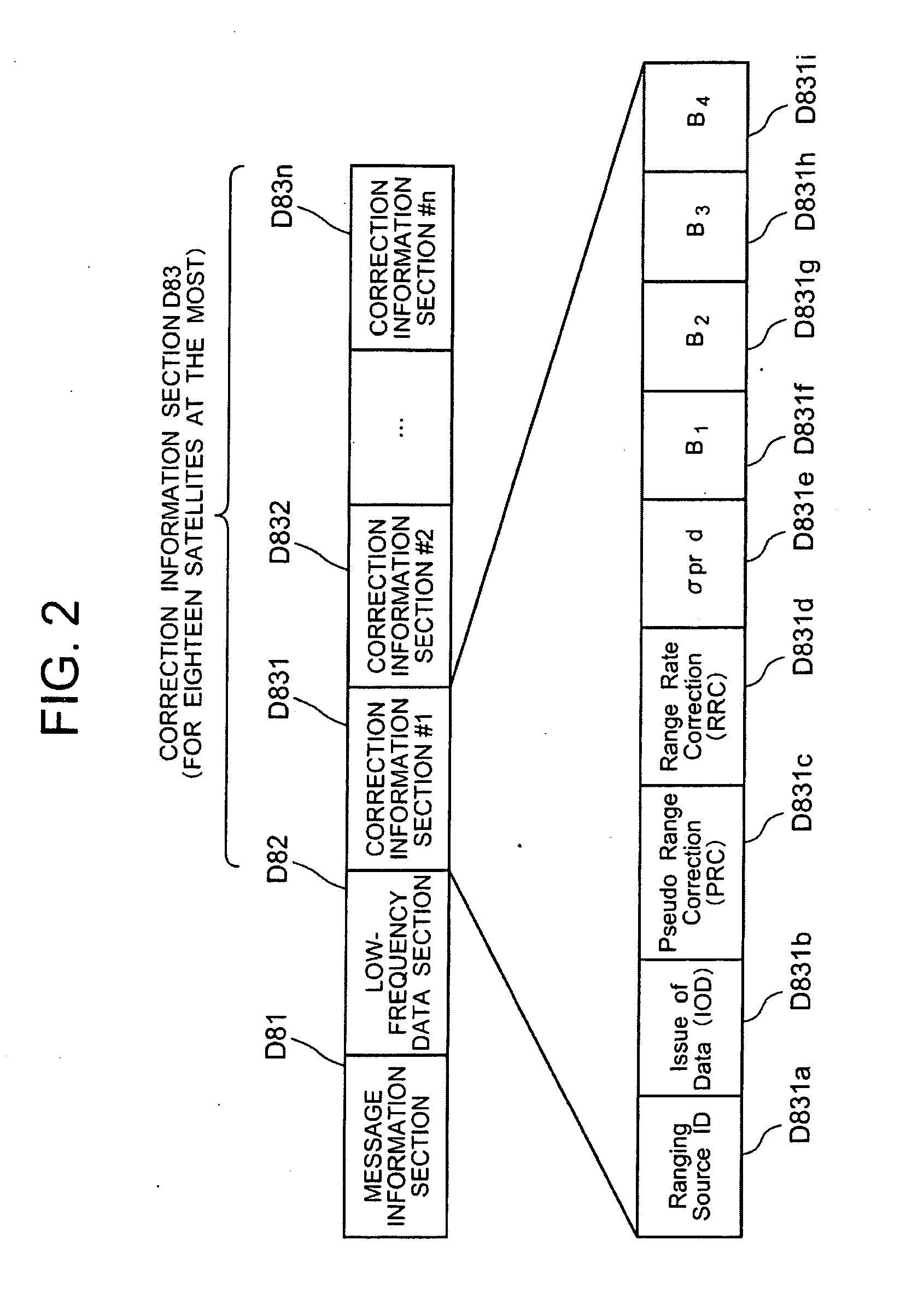
[0029]As shown in FIG. 1, an SBAS navigation data update notifying system in GBAS according to the exemplary embodiment of the invention is a navigation data update notifying system loaded in a ground based augmentation system which utilizes information provided from an SBAS satellite 1 and GPS satellites 41-4n. As a basic structure, the SBAS navigation data update notifying system includes: a ground system 2 which estimates errors contained in ranging signals D2 received from the satellites, and formats and transmits correction information for correcting the estimated errors; and an airborne system 3 which calculates differential GPS positioning based on the ranging signals and the formatted correction information, and displays the displacement from a regulated route.

[0030]Further, the ground system 2 has a notifying device which adds the update of the nav...


PUM


Abstract

To maintain the safety by avoiding deterioration in the positioning accuracy through making SBAS satellite navigation data used in a ground system and in an airborne system consistent by employing GBAS. The system includes: a ground system which estimates errors contained in ranging signals received from the navigation satellites, and formats and transmits correction information for correcting the estimated errors; and an airborne system which calculates differential GPS positioning based on the ranging signals received from the navigation satellites and the formatted correction information, and displays a displacement from a regulated route. The ground system notifies update, when SBAS satellite navigation data used for generating the correction information is updated, by adding information regarding update of navigation data to the correction information. The airborne system detects the transmitted update notification of the SBAS satellite navigation data, and calculates the differential GPS positioning by switching to the updated navigation data.

Description

CROSS-REFERENCE TO RELATED APPLICATION[0001]This application is based upon and claims the benefit of priority from Japanese patent application No. 2008-099479, filed on Apr. 7, 2008, the disclosure of which is incorporated herein in its entirety by reference.BACKGROUND OF THE INVENTION[0002]1. Field of the Invention[0003]The present invention relates to an SBAS navigation data update notifying system and method used in a ground based augmentation system (GBAS), which can improve the safety by avoiding deterioration in a positioning accuracy caused because SBAS data used in a ground system and in an airborne system which configure the GBAS are different.[0004]2. Description of the Related Art[0005]There have been conducted operations of systems which use four or more navigation satellites for navigations of flying objects such as airplanes (Japanese Unexamined Patent Publication 2000-275317: Patent Document 1, Japanese Unexamined Patent Publication 2003-18061: Patent Document 2, Japa...

Claims


Application Information

Patent Timeline
Patent Type & Authority Applications(United States)
IPC IPC(8): G01S5/14G01S19/07G01S19/15G01S19/41
CPCG01S19/41G01S19/07G01S19/074
Inventor SUZUKI, KAZUSHI
Owner NEC CORP
Why Eureka
Try Eureka